Property Record
4350 E 71St St, Cleveland, OH 44105
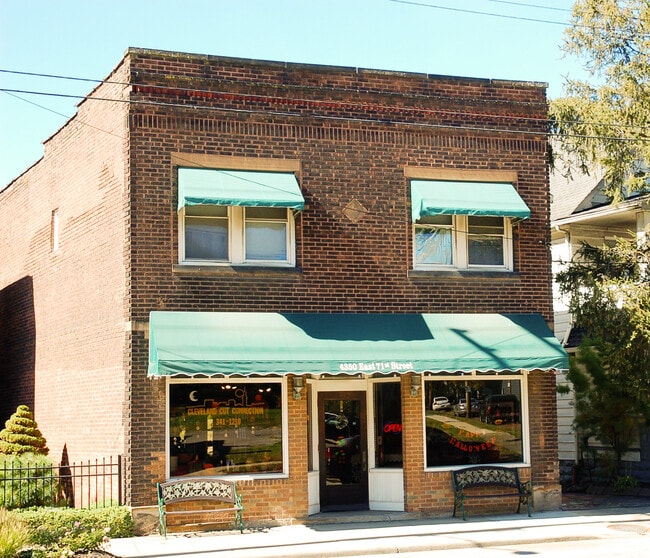


This Property Is For Sale
Property Detail
4350 E 71St St
132-29-027
306 KRAKOW 0006 ALL
Retailwithmorethanonenonretailuse
CUYAHOGA
LR
Ohio
B and X Area of moderate flood hazard, usually the area between the limits of the 100-year and 500-year floods.
6
2025
0.11 AC
2025
South
115700
Cleveland
3,196 SF
Cleveland-Elyria, OH
NEARBY LISTINGS FOR SALE OR LEASE
DEMOGRAPHICS near 4350 E 71St St
1 mile
3 mile
5 mile
2025 Total Population
9,567
75,124
293,316
2030 Population
9,302
73,998
290,283
Pop Growth 2025-2030
(2.77%)
(1.50%)
(1.03%)
Average Age
38
40
40
2025 Total Households
3,927
31,752
129,609
HH Growth 2025-2030
(3.13%)
(1.72%)
(0.96%)
Median Household Inc
$41,848
$42,018
$48,168
Avg Household Size
2.30
2.30
2.10
2025 Avg HH Vehicles
1.00
1.00
1.00
Median Home Value
$72,681
$87,667
$129,533
Median Year Built
1946
1948
1949
Nearby Places
Map Layers
Map Styles
 Street
 Aerial
Layers
 Traffic
 Biking
Places
Listings with unknown addresses are not visible on the map
- Restaurants
- Banks
- Shops
- Fitness
- Groceries
PUBLIC TRANSPORTATION
COMMUTER RAIL
Drive
Walk
Distance
11 min
3.9 mi
Drive
Walk
Distance
13 min
5.6 mi
AIRPORT
Cleveland-Hopkins International
Drive
Walk
Distance
Cleveland-Hopkins International
24 min
15.1 mi
Nearby Properties
Address
Land Use
TOTAL SIZE
Lot Size
Zoning
Address
Land Use
TOTAL SIZE
Lot Size
Zoning
162,711 SF
192.04 AC
IG
Address
Land Use
TOTAL SIZE
Lot Size
Zoning
230,820 SF
41.47 AC
UI
Address
Land Use
TOTAL SIZE
Lot Size
Zoning
32,400 SF
52.29 AC
U-4
Address
Land Use
TOTAL SIZE
Lot Size
Zoning
186,275 SF
17.80 AC
U-8
Address
Land Use
TOTAL SIZE
Lot Size
Zoning
384,714 SF
4.75 AC
U-5-HR
Address
Land Use
TOTAL SIZE
Lot Size
Zoning
194,257 SF
94.46 AC
IG
Address
Land Use
TOTAL SIZE
Lot Size
Zoning
595.30 AC
UI
Address
Land Use
TOTAL SIZE
Lot Size
Zoning
129,112 SF
24.11 AC
U-8
Address
Land Use
TOTAL SIZE
Lot Size
Zoning
248,498 SF
14.31 AC
U-8
Address
Land Use
TOTAL SIZE
Lot Size
Zoning
205,724 SF
6.54 AC
U-8
Address
Land Use
TOTAL SIZE
Lot Size
Zoning
12.64 AC
U-4
Address
Land Use
TOTAL SIZE
Lot Size
Zoning
189,156 SF
24.49 AC
IG
Address
Land Use
TOTAL SIZE
Lot Size
Zoning
221,406 SF
12.05 AC
2F
Address
Land Use
TOTAL SIZE
Lot Size
Zoning
500,398 SF
24.49 AC
IG
Address
Land Use
TOTAL SIZE
Lot Size
Zoning
180,175 SF
111.96 AC
IG
Address
Land Use
TOTAL SIZE
Lot Size
Zoning
209,068 SF
23.10 AC
IG
Address
Land Use
TOTAL SIZE
Lot Size
Zoning
239,000 SF
6.29 AC
U-6A
Address
Land Use
TOTAL SIZE
Lot Size
Zoning
277,049 SF
24.15 AC
2F
Address
Land Use
TOTAL SIZE
Lot Size
Zoning
156,790 SF
11.28 AC
GR
Address
Land Use
TOTAL SIZE
Lot Size
Zoning
19.48 AC
U5-A
Address
Land Use
TOTAL SIZE
Lot Size
Zoning
133,913 SF
18.36 AC
U-11B
Address
Land Use
TOTAL SIZE
Lot Size
Zoning
8.60 AC
U-4
Address
Land Use
TOTAL SIZE
Lot Size
Zoning
116,373 SF
13.28 AC
U-3
Address
Land Use
TOTAL SIZE
Lot Size
Zoning
141,785 SF
9.13 AC
U-5
Address
Land Use
TOTAL SIZE
Lot Size
Zoning
336,730 SF
38.51 AC
U-11A
Address
Land Use
TOTAL SIZE
Lot Size
Zoning
197,916 SF
9.10 AC
MF-1
Address
Land Use
TOTAL SIZE
Lot Size
Zoning
172,448 SF
13.95 AC
Address
Land Use
TOTAL SIZE
Lot Size
Zoning
173,110 SF
6.38 AC
U-8
Address
Land Use
TOTAL SIZE
Lot Size
Zoning
73,764 SF
6.39 AC
2F
Address
Land Use
TOTAL SIZE
Lot Size
Zoning
64,903 SF
3.48 AC
2F
The World's #1 Commercial Real Estate Marketplace
Connect with us
© 2026 CoStar Group
The information above has been obtained from sources believed reliable. While we do not doubt its accuracy we have not verified it and make no guarantee, warranty or representation about it. It is your responsibility to independently confirm its accuracy and completeness. Any projections, opinions, assumptions, or estimates used are for example only and do not represent the current or future performance of the property. The value of this transaction to you depends on tax and other factors which should be evaluated by your tax, financial, and legal advisors. You and your advisors should conduct a careful, independent investigation of the property to determine to your satisfaction the suitability of the property for your needs.