Property Record
4350 E Boyd Rd, Decatur, IL 62521
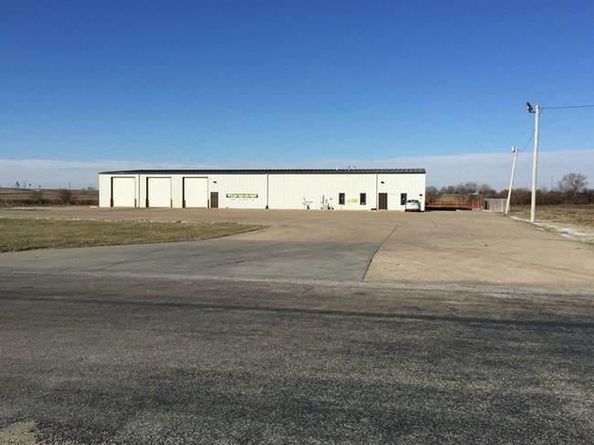

Property Detail
4350 E Boyd Rd
18-08-20-328-001
SHUR-CO ADD L 1
Warehouse
Macon
B-2
Illinois
B and X Area of moderate flood hazard, usually the area between the limits of the 100-year and 500-year floods.
4.79 AC
2024
Springfield/Decatur
2024
Other Market Areas
002200
Decatur, IL
NEARBY LISTINGS FOR SALE OR LEASE
DEMOGRAPHICS near 4350 E Boyd Rd
1 mile
3 mile
5 mile
2025 Total Population
216
6,671
31,878
2030 Population
212
6,475
31,282
Pop Growth 2025-2030
(1.85%)
(2.94%)
(1.87%)
Average Age
46
39
42
2025 Total Households
90
2,824
14,227
HH Growth 2025-2030
(2.22%)
(3.12%)
(1.93%)
Median Household Inc
$89,285
$49,745
$49,975
Avg Household Size
2.40
2.20
2.10
2025 Avg HH Vehicles
2.00
2.00
2.00
Median Home Value
$209,091
$109,722
$109,219
Median Year Built
1973
1973
1970
Nearby Places
Map Layers
Map Styles
 Street
 Aerial
Layers
 Traffic
 Biking
Places
Listings with unknown addresses are not visible on the map
- Restaurants
- Banks
- Shops
- Fitness
- Groceries
SALE & LEASE HISTORY
LISTING DATE
SALE/LEASE

Sep 25, 2016
For Lease
Nearby Properties
Address
Land Use
TOTAL SIZE
Lot Size
Zoning
Address
Land Use
TOTAL SIZE
Lot Size
Zoning
10 AC
MUNICIPAL
Address
Land Use
TOTAL SIZE
Lot Size
Zoning
38.36 AC
MUNICIPAL
Address
Land Use
TOTAL SIZE
Lot Size
Zoning
107.54 AC
MUNICIPAL
Address
Land Use
TOTAL SIZE
Lot Size
Zoning
76.02 AC
MUNICIPAL
Address
Land Use
TOTAL SIZE
Lot Size
Zoning
13.75 AC
MUNICIPAL
Address
Land Use
TOTAL SIZE
Lot Size
Zoning
17.82 AC
MUNICIPAL
Address
Land Use
TOTAL SIZE
Lot Size
Zoning
23.56 AC
MUNICIPAL
Address
Land Use
TOTAL SIZE
Lot Size
Zoning
14.66 AC
MUNICIPAL
Address
Land Use
TOTAL SIZE
Lot Size
Zoning
13.04 AC
MUNICIPAL
Address
Land Use
TOTAL SIZE
Lot Size
Zoning
20 AC
MUNICIPAL
Address
Land Use
TOTAL SIZE
Lot Size
Zoning
61.42 AC
MUNICIPAL
Address
Land Use
TOTAL SIZE
Lot Size
Zoning
9.53 AC
MUNICIPAL
Address
Land Use
TOTAL SIZE
Lot Size
Zoning
35.07 AC
MUNICIPAL
Address
Land Use
TOTAL SIZE
Lot Size
Zoning
14.73 AC
MUNICIPAL
Address
Land Use
TOTAL SIZE
Lot Size
Zoning
15.93 AC
M-1
Address
Land Use
TOTAL SIZE
Lot Size
Zoning
7.38 AC
MUNICIPAL
Address
Land Use
TOTAL SIZE
Lot Size
Zoning
16.42 AC
MUNICIPAL
Address
Land Use
TOTAL SIZE
Lot Size
Zoning
4,000 SF
5.18 AC
MUNICIPAL
Address
Land Use
TOTAL SIZE
Lot Size
Zoning
5 AC
MUNICIPAL
Address
Land Use
TOTAL SIZE
Lot Size
Zoning
7 AC
MUNICIPAL
Address
Land Use
TOTAL SIZE
Lot Size
Zoning
3.10 AC
MUNICIPAL
Address
Land Use
TOTAL SIZE
Lot Size
Zoning
12.24 AC
MUNICIPAL
Address
Land Use
TOTAL SIZE
Lot Size
Zoning
11.28 AC
MUNICIPAL
Address
Land Use
TOTAL SIZE
Lot Size
Zoning
4.08 AC
MUNICIPAL
Address
Land Use
TOTAL SIZE
Lot Size
Zoning
5.69 AC
MUNICIPAL
Address
Land Use
TOTAL SIZE
Lot Size
Zoning
3.15 AC
MUNICIPAL
Address
Land Use
TOTAL SIZE
Lot Size
Zoning
1.92 AC
MUNICIPAL
The World's #1 Commercial Real Estate Marketplace
Connect with us
© 2026 CoStar Group
The information above has been obtained from sources believed reliable. While we do not doubt its accuracy we have not verified it and make no guarantee, warranty or representation about it. It is your responsibility to independently confirm its accuracy and completeness. Any projections, opinions, assumptions, or estimates used are for example only and do not represent the current or future performance of the property. The value of this transaction to you depends on tax and other factors which should be evaluated by your tax, financial, and legal advisors. You and your advisors should conduct a careful, independent investigation of the property to determine to your satisfaction the suitability of the property for your needs.