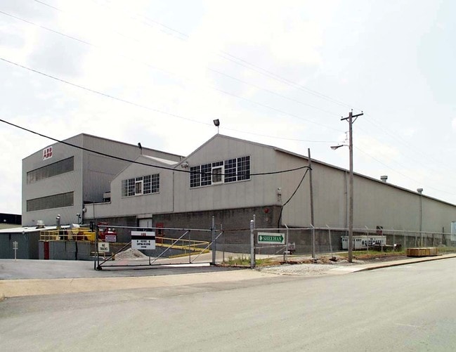
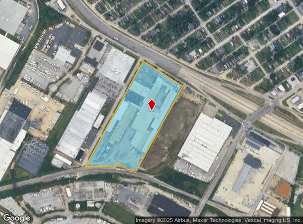
Property Record
5400 Bircher Blvd, Saint Louis, MO 63120
Current Lease Availabilities
NEARBY LISTINGS FOR SALE OR LEASE
Property Detail
5400 Bircher Blvd
9104-00-0010-0
Surv 3331 Addn
Officebuilding
O. L. 104 BIRCHER 17.04 ACRES SURV 3331 ADDN BND N-BIRCHER
X
St. Louis City
29189C0209K
Missouri
2024
17.04 AC
2025
St Louis City North
126900
St. Louis
428,452 SF
St. Louis, MO-IL
DEMOGRAPHICS near 5400 Bircher Blvd
1 Mile
3 Mile
5 Mile
2024 Total Population
11,899
115,770
276,803
2029 Population
11,735
115,273
273,153
Pop Growth 2024-2029
(1.38%)
(0.43%)
(1.32%)
Average Age
42
41
39
2024 Total Households
5,062
50,000
121,232
HH Growth 2024-2029
(1.24%)
(0.49%)
(1.59%)
Median Household Inc
$31,770
$34,506
$40,635
Avg Household Size
2.30
2.20
2.10
2024 Avg HH Vehicles
1.00
1.00
1.00
Median Home Value
$65,587
$76,322
$98,952
Median Year Built
1947
1948
1951
Nearby Places
- Restaurants
- Banks
- Shops
- Fitness
- Groceries
PUBLIC TRANSPORTATION
COMMUTER RAIL
Wellston (Lambert Airport Shiloh-Scott - St. Louis MetroLink (MetroLink))
DRIVE
WALK
Distance
Wellston (Lambert Airport Shiloh-Scott - St. Louis MetroLink (MetroLink))
9 min
4.6 mi
Rock Road (Lambert Airport Shiloh-Scott - St. Louis MetroLink (MetroLink))
DRIVE
WALK
Distance
Rock Road (Lambert Airport Shiloh-Scott - St. Louis MetroLink (MetroLink))
9 min
4.7 mi
AIRPORT
St Louis Lambert International
DRIVE
WALK
Distance
St Louis Lambert International
14 min
8.4 mi
Scott AFB/Midamerica St Louis
DRIVE
WALK
Distance
Scott AFB/Midamerica St Louis
46 min
30.6 mi
Freight Ports
Port Milwaukee
DRIVE
WALK
Distance
Port Milwaukee
424 min
374.9 mi
Nearby Properties
Address
Land Use
TOTAL SIZE
Lot Size
Zoning
Address
Land Use
TOTAL SIZE
Lot Size
Zoning
Address
Land Use
TOTAL SIZE
Lot Size
Zoning
124.96 AC
J
Address
Land Use
TOTAL SIZE
Lot Size
Zoning
152.07 AC
L
Address
Land Use
TOTAL SIZE
Lot Size
Zoning
7.94 AC
D
Address
Land Use
TOTAL SIZE
Lot Size
Zoning
348,233 SF
23.68 AC
Address
Land Use
TOTAL SIZE
Lot Size
Zoning
101,200 SF
1.10 AC
E
Address
Land Use
TOTAL SIZE
Lot Size
Zoning
46.18 AC
A
Address
Land Use
TOTAL SIZE
Lot Size
Zoning
18.32 AC
PA
Address
Land Use
TOTAL SIZE
Lot Size
Zoning
5,640 SF
10.42 AC
A
Address
Land Use
TOTAL SIZE
Lot Size
Zoning
15,149 SF
120.85 AC
A
Address
Land Use
TOTAL SIZE
Lot Size
Zoning
51,460 SF
101.96 AC
K
Address
Land Use
TOTAL SIZE
Lot Size
Zoning
229.57 AC
A
Address
Land Use
TOTAL SIZE
Lot Size
Zoning
14,150 SF
20 AC
39SFR
Address
Land Use
TOTAL SIZE
Lot Size
Zoning
4.07 AC
31R-1
Address
Land Use
TOTAL SIZE
Lot Size
Zoning
38.62 AC
AF
Address
Land Use
TOTAL SIZE
Lot Size
Zoning
20.34 AC
NU
Address
Land Use
TOTAL SIZE
Lot Size
Zoning
471,077 SF
16.09 AC
K
Address
Land Use
TOTAL SIZE
Lot Size
Zoning
155,132 SF
4.54 AC
G
Address
Land Use
TOTAL SIZE
Lot Size
Zoning
1.80 AC
31R-1
Address
Land Use
TOTAL SIZE
Lot Size
Zoning
125,748 SF
0.61 AC
H
Address
Land Use
TOTAL SIZE
Lot Size
Zoning
130.85 AC
B
Address
Land Use
TOTAL SIZE
Lot Size
Zoning
210,255 SF
7.37 AC
77MULTI
Address
Land Use
TOTAL SIZE
Lot Size
Zoning
56,919 SF
2.18 AC
B
Address
Land Use
TOTAL SIZE
Lot Size
Zoning
Address
Land Use
TOTAL SIZE
Lot Size
Zoning
127.48 AC
B
Address
Land Use
TOTAL SIZE
Lot Size
Zoning
88,466 SF
2.13 AC
31C-2S
Address
Land Use
TOTAL SIZE
Lot Size
Zoning
297,169 SF
18.01 AC
K
Address
Land Use
TOTAL SIZE
Lot Size
Zoning
24,392 SF
2.26 AC
F
Address
Land Use
TOTAL SIZE
Lot Size
Zoning
5.23 AC
31R-1
Address
Land Use
TOTAL SIZE
Lot Size
Zoning
51,222 SF
5.23 AC
31C-3
The World's #1 Commercial Real Estate Marketplace
Connect with us
© 2025 CoStar Group
The information above has been obtained from sources believed reliable. While we do not doubt its accuracy we have not verified it and make no guarantee, warranty or representation about it. It is your responsibility to independently confirm its accuracy and completeness. Any projections, opinions, assumptions, or estimates used are for example only and do not represent the current or future performance of the property. The value of this transaction to you depends on tax and other factors which should be evaluated by your tax, financial, and legal advisors. You and your advisors should conduct a careful, independent investigation of the property to determine to your satisfaction the suitability of the property for your needs.