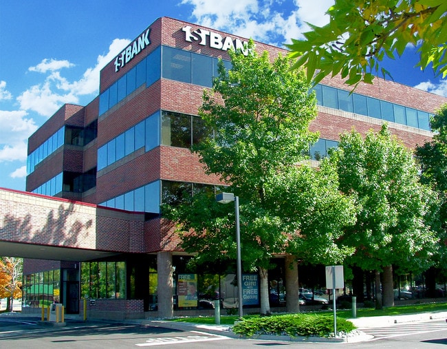
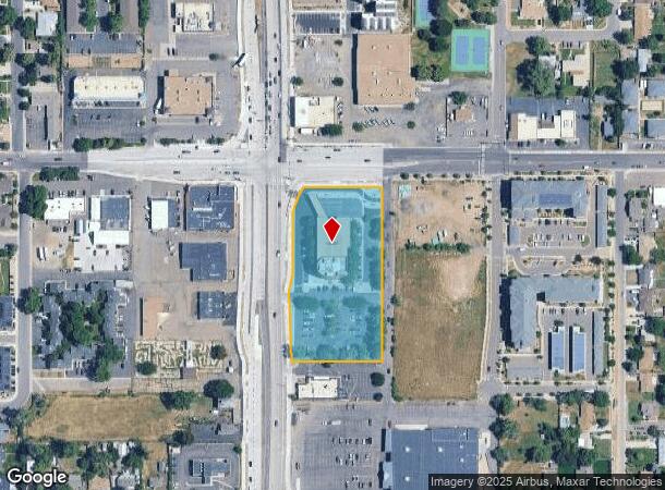
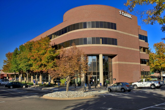
Property Record
4350 Wadsworth Blvd, Wheat Ridge, CO 80033

Current Lease Availabilities
NEARBY LISTINGS FOR SALE OR LEASE
Property Detail
4350 Wadsworth Blvd
Denver-Aurora-Lakewood, CO
SECTION 23 TOWNSHIP 03 RANGE 69 QTR SE SIZE: 118727 VALUE: 2.726 KEY=016
39-234-00-106
Jefferson
Commercialnec
Colorado
2023
2.73 AC
2024
West Denver
010603
Denver
54,962 SF
DEMOGRAPHICS near 4350 Wadsworth Blvd
1 Mile
3 Mile
5 Mile
2024 Total Population
13,002
129,378
357,199
2029 Population
12,993
129,163
359,577
Pop Growth 2024-2029
(0.07%)
(0.17%)
+ 0.67%
Average Age
44
40
39
2024 Total Households
6,018
58,220
156,666
HH Growth 2024-2029
(0.08%)
(0.28%)
+ 0.74%
Median Household Inc
$72,622
$78,832
$82,871
Avg Household Size
2.10
2.10
2.20
2024 Avg HH Vehicles
2.00
2.00
2.00
Median Home Value
$515,615
$562,521
$553,107
Median Year Built
1961
1965
1972
Nearby Places
- Restaurants
- Banks
- Shops
- Fitness
- Groceries
PUBLIC TRANSPORTATION
COMMUTER RAIL
Olde Town Arvada W-Bound (Union Station to Wheat Ridge Ward Station - Regional Transportation District)
DRIVE
WALK
Distance
Olde Town Arvada W-Bound (Union Station to Wheat Ridge Ward Station - Regional Transportation District)
4 min
1.7 mi
Olde Town Arvada E-Bound (Union Station to Wheat Ridge Ward Station - Regional Transportation District)
DRIVE
WALK
Distance
Olde Town Arvada E-Bound (Union Station to Wheat Ridge Ward Station - Regional Transportation District)
4 min
1.9 mi
AIRPORT
Denver International
DRIVE
WALK
Distance
Denver International
36 min
27.8 mi
Freight Ports
Tulsa Port Of Catoosa
DRIVE
WALK
Distance
Tulsa Port Of Catoosa
733 min
713.4 mi
Nearby Properties
Address
Land Use
TOTAL SIZE
Lot Size
Zoning
Address
Land Use
TOTAL SIZE
Lot Size
Zoning
860,132 SF
68.50 AC
R-5
Address
Land Use
TOTAL SIZE
Lot Size
Zoning
111,673 SF
29.06 AC
Address
Land Use
TOTAL SIZE
Lot Size
Zoning
298,150 SF
24.21 AC
Address
Land Use
TOTAL SIZE
Lot Size
Zoning
187,095 SF
23.42 AC
Address
Land Use
TOTAL SIZE
Lot Size
Zoning
6,731 SF
80.77 AC
Address
Land Use
TOTAL SIZE
Lot Size
Zoning
436,238 SF
13.94 AC
Address
Land Use
TOTAL SIZE
Lot Size
Zoning
310,267 SF
1.69 AC
C-MX
Address
Land Use
TOTAL SIZE
Lot Size
Zoning
212,995 SF
3.20 AC
R-3
Address
Land Use
TOTAL SIZE
Lot Size
Zoning
389,561 SF
10.73 AC
Address
Land Use
TOTAL SIZE
Lot Size
Zoning
142,635 SF
6.84 AC
U-SU-B1
Address
Land Use
TOTAL SIZE
Lot Size
Zoning
131,135 SF
2.83 AC
Address
Land Use
TOTAL SIZE
Lot Size
Zoning
262,699 SF
13.10 AC
A2
Address
Land Use
TOTAL SIZE
Lot Size
Zoning
311,200 SF
0.85 AC
Address
Land Use
TOTAL SIZE
Lot Size
Zoning
138,204 SF
3.68 AC
Address
Land Use
TOTAL SIZE
Lot Size
Zoning
76,078 SF
6.64 AC
U-SU-C
Address
Land Use
TOTAL SIZE
Lot Size
Zoning
111,478 SF
8.24 AC
CMP
Address
Land Use
TOTAL SIZE
Lot Size
Zoning
87,567 SF
14.98 AC
R-5
Address
Land Use
TOTAL SIZE
Lot Size
Zoning
115,719 SF
5.93 AC
Address
Land Use
TOTAL SIZE
Lot Size
Zoning
142,200 SF
9.82 AC
Address
Land Use
TOTAL SIZE
Lot Size
Zoning
7,826 SF
0.48 AC
Address
Land Use
TOTAL SIZE
Lot Size
Zoning
73,915 SF
2.89 AC
U-TU-C
Address
Land Use
TOTAL SIZE
Lot Size
Zoning
163,361 SF
17.09 AC
Address
Land Use
TOTAL SIZE
Lot Size
Zoning
91,734 SF
9.69 AC
Address
Land Use
TOTAL SIZE
Lot Size
Zoning
73,269 SF
3.72 AC
U-SU-B1
Address
Land Use
TOTAL SIZE
Lot Size
Zoning
84,061 SF
9.08 AC
Address
Land Use
TOTAL SIZE
Lot Size
Zoning
54,353 SF
2.73 AC
Address
Land Use
TOTAL SIZE
Lot Size
Zoning
144,325 SF
13.22 AC
Address
Land Use
TOTAL SIZE
Lot Size
Zoning
114,348 SF
3 AC
Address
Land Use
TOTAL SIZE
Lot Size
Zoning
139,913 SF
2.87 AC
Address
Land Use
TOTAL SIZE
Lot Size
Zoning
121,389 SF
3.58 AC
The World's #1 Commercial Real Estate Marketplace
Connect with us
© 2025 CoStar Group
The information above has been obtained from sources believed reliable. While we do not doubt its accuracy we have not verified it and make no guarantee, warranty or representation about it. It is your responsibility to independently confirm its accuracy and completeness. Any projections, opinions, assumptions, or estimates used are for example only and do not represent the current or future performance of the property. The value of this transaction to you depends on tax and other factors which should be evaluated by your tax, financial, and legal advisors. You and your advisors should conduct a careful, independent investigation of the property to determine to your satisfaction the suitability of the property for your needs.