Property Record
4351 Mahan Dr, Tallahassee, FL 32308


NEARBY LISTINGS FOR SALE OR LEASE
-
-
View all Tallahassee listings for sale on LoopNet.com
Property Detail
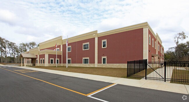
4351 Mahan Dr
Tallahassee, FL
Unplatted Land
11-23-20-618-000.0
23 1N 1E IN S/W 1/4 BEING LOT 1 OF A BS OR 1355/1390 4304/684(UT) 4314/119(BS)
Privateschool
Leon
X
Florida
12073C0304F
1
2025
7.90 AC
2025
Northeast Leon County
002505
Tallahassee
64,835 SF
DEMOGRAPHICS near 4351 Mahan Dr
1 Mile
3 Mile
5 Mile
2024 Total Population
4,336
43,212
102,329
2029 Population
4,615
45,753
108,370
Pop Growth 2024-2029
+ 6.43%
+ 5.88%
+ 5.90%
Average Age
46
41
40
2024 Total Households
2,009
18,919
46,440
HH Growth 2024-2029
+ 6.52%
+ 6.16%
+ 6.15%
Median Household Inc
$76,676
$70,108
$70,108
Avg Household Size
2.10
2.10
2.10
2024 Avg HH Vehicles
2.00
2.00
2.00
Median Home Value
$297,184
$262,121
$283,623
Median Year Built
1996
1992
1986
Nearby Places
Map Layers
Map Styles
 Street
 Aerial
- Restaurants
- Banks
- Shops
- Fitness
- Groceries
PUBLIC TRANSPORTATION
AIRPORT
Tallahassee International
DRIVE
WALK
Distance
Tallahassee International
25 min
12.5 mi
SALE & LEASE HISTORY
LISTING DATE
SALE/LEASE

Dec 18, 2024
For Sale
Nearby Properties
Address
Land Use
TOTAL SIZE
Lot Size
Zoning
Address
Land Use
TOTAL SIZE
Lot Size
Zoning
2,588,854 SF
110.33 AC
IC
Address
Land Use
TOTAL SIZE
Lot Size
Zoning
1,906,594 SF
112.75 AC
PUD
Address
Land Use
TOTAL SIZE
Lot Size
Zoning
361,804 SF
14.17 AC
CM
Address
Land Use
TOTAL SIZE
Lot Size
Zoning
577,345 SF
30.63 AC
Address
Land Use
TOTAL SIZE
Lot Size
Zoning
846,072 SF
166.39 AC
R1
Address
Land Use
TOTAL SIZE
Lot Size
Zoning
545,485 SF
14.01 AC
Address
Land Use
TOTAL SIZE
Lot Size
Zoning
756,294 SF
20.19 AC
OR3
Address
Land Use
TOTAL SIZE
Lot Size
Zoning
456,149 SF
22.50 AC
OR3
Address
Land Use
TOTAL SIZE
Lot Size
Zoning
775,087 SF
18.34 AC
Address
Land Use
TOTAL SIZE
Lot Size
Zoning
708,504 SF
50.44 AC
PUD
Address
Land Use
TOTAL SIZE
Lot Size
Zoning
543,726 SF
13.13 AC
PUD
Address
Land Use
TOTAL SIZE
Lot Size
Zoning
338,790 SF
16 AC
PUD
Address
Land Use
TOTAL SIZE
Lot Size
Zoning
338,619 SF
107.89 AC
GO1
Address
Land Use
TOTAL SIZE
Lot Size
Zoning
606,101 SF
19.01 AC
MR1
Address
Land Use
TOTAL SIZE
Lot Size
Zoning
312,935 SF
11.74 AC
MR1
Address
Land Use
TOTAL SIZE
Lot Size
Zoning
312,935 SF
12.82 AC
MR1
Address
Land Use
TOTAL SIZE
Lot Size
Zoning
456,212 SF
117.40 AC
MR1
Address
Land Use
TOTAL SIZE
Lot Size
Zoning
312,392 SF
14.52 AC
MR1
Address
Land Use
TOTAL SIZE
Lot Size
Zoning
534,652 SF
57.35 AC
MR1
Address
Land Use
TOTAL SIZE
Lot Size
Zoning
247,794 SF
17.24 AC
CP
Address
Land Use
TOTAL SIZE
Lot Size
Zoning
257,119 SF
36.46 AC
CPA
Address
Land Use
TOTAL SIZE
Lot Size
Zoning
145,652 SF
7.89 AC
M1
Address
Land Use
TOTAL SIZE
Lot Size
Zoning
319,584 SF
14.67 AC
PUD
Address
Land Use
TOTAL SIZE
Lot Size
Zoning
148,189 SF
6.14 AC
Address
Land Use
TOTAL SIZE
Lot Size
Zoning
416,738 SF
14.93 AC
MR1
Address
Land Use
TOTAL SIZE
Lot Size
Zoning
398,700 SF
18.12 AC
OR3
Address
Land Use
TOTAL SIZE
Lot Size
Zoning
54,821 SF
22.02 AC
CM
Address
Land Use
TOTAL SIZE
Lot Size
Zoning
211,154 SF
18.85 AC
PUD
Address
Land Use
TOTAL SIZE
Lot Size
Zoning
286,241 SF
25.04 AC
MR1
Address
Land Use
TOTAL SIZE
Lot Size
Zoning
197,888 SF
28.27 AC
CP
The World's #1 Commercial Real Estate Marketplace
Connect with us
© 2026 CoStar Group
The information above has been obtained from sources believed reliable. While we do not doubt its accuracy we have not verified it and make no guarantee, warranty or representation about it. It is your responsibility to independently confirm its accuracy and completeness. Any projections, opinions, assumptions, or estimates used are for example only and do not represent the current or future performance of the property. The value of this transaction to you depends on tax and other factors which should be evaluated by your tax, financial, and legal advisors. You and your advisors should conduct a careful, independent investigation of the property to determine to your satisfaction the suitability of the property for your needs.