Property Record
4352 Canton Hwy, Cumming, GA 30040

NEARBY LISTINGS FOR SALE OR LEASE
-
-
View all Cumming listings for sale on LoopNet.com
Property Detail
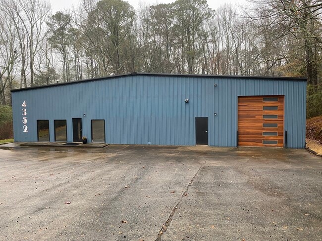
4352 Canton Hwy
009-063
3-1 939 0.018 AC TO ROW PER 9922/0052 0.62 AC---2021
Warehouse
Forsyth
X
Georgia
13117C0130G
0.62 AC
2024
N Fulton/Forsyth Cnty
2025
Atlanta
130303
Atlanta-Sandy Springs-Roswell, GA
6,400 SF
DEMOGRAPHICS near 4352 Canton Hwy
1 Mile
3 Mile
5 Mile
2024 Total Population
3,717
26,288
69,908
2029 Population
4,314
30,710
81,257
Pop Growth 2024-2029
+ 16.06%
+ 16.82%
+ 16.23%
Average Age
38
39
40
2024 Total Households
1,211
8,613
22,862
HH Growth 2024-2029
+ 16.18%
+ 16.88%
+ 16.28%
Median Household Inc
$122,221
$125,397
$133,338
Avg Household Size
3.00
3.00
3.00
2024 Avg HH Vehicles
2.00
2.00
2.00
Median Home Value
$464,999
$453,023
$464,581
Median Year Built
2003
2006
2004
Nearby Places
Map Layers
Map Styles
 Street
 Aerial
- Restaurants
- Banks
- Shops
- Fitness
- Groceries
SALE & LEASE HISTORY
LISTING DATE
SALE/LEASE

Mar 06, 2025
For Sale
Dec 13, 2023
For Lease
Nearby Properties
Address
Land Use
TOTAL SIZE
Lot Size
Zoning
Address
Land Use
TOTAL SIZE
Lot Size
Zoning
234,450 SF
95 AC
A1
Address
Land Use
TOTAL SIZE
Lot Size
Zoning
1,040 SF
9.53 AC
CBD
Address
Land Use
TOTAL SIZE
Lot Size
Zoning
1,294 SF
44.80 AC
A1
Address
Land Use
TOTAL SIZE
Lot Size
Zoning
55,984 SF
5.80 AC
O&I
Address
Land Use
TOTAL SIZE
Lot Size
Zoning
65,612 SF
6.83 AC
CBD
Address
Land Use
TOTAL SIZE
Lot Size
Zoning
108,303 SF
39.38 AC
AG
Address
Land Use
TOTAL SIZE
Lot Size
Zoning
138,770 SF
33.19 AC
A1
Address
Land Use
TOTAL SIZE
Lot Size
Zoning
68,520 SF
12.35 AC
GC
Address
Land Use
TOTAL SIZE
Lot Size
Zoning
4.06 AC
CBD
Address
Land Use
TOTAL SIZE
Lot Size
Zoning
28,914 SF
277.46 AC
PUD
Address
Land Use
TOTAL SIZE
Lot Size
Zoning
81,455 SF
3.69 AC
CBD
Address
Land Use
TOTAL SIZE
Lot Size
Zoning
9,858 SF
18.06 AC
A1
Address
Land Use
TOTAL SIZE
Lot Size
Zoning
7,339 SF
15.43 AC
A1
Address
Land Use
TOTAL SIZE
Lot Size
Zoning
39,000 SF
3.14 AC
CBD
Address
Land Use
TOTAL SIZE
Lot Size
Zoning
10,469 SF
39.86 AC
A1
Address
Land Use
TOTAL SIZE
Lot Size
Zoning
74.15 AC
AG
Address
Land Use
TOTAL SIZE
Lot Size
Zoning
37,584 SF
3.29 AC
CBD
Address
Land Use
TOTAL SIZE
Lot Size
Zoning
33,508 SF
6.43 AC
R-40
Address
Land Use
TOTAL SIZE
Lot Size
Zoning
2,125 SF
CBD
Address
Land Use
TOTAL SIZE
Lot Size
Zoning
60 AC
AG
Address
Land Use
TOTAL SIZE
Lot Size
Zoning
24,703 SF
3.75 AC
PUD
Address
Land Use
TOTAL SIZE
Lot Size
Zoning
13,092 SF
1.55 AC
CBD
Address
Land Use
TOTAL SIZE
Lot Size
Zoning
22,254 SF
14.04 AC
M1
Address
Land Use
TOTAL SIZE
Lot Size
Zoning
8,817 SF
44.30 AC
A1
Address
Land Use
TOTAL SIZE
Lot Size
Zoning
59.23 AC
A1
Address
Land Use
TOTAL SIZE
Lot Size
Zoning
54,290 SF
4 AC
M1
Address
Land Use
TOTAL SIZE
Lot Size
Zoning
3.47 AC
CBD
Address
Land Use
TOTAL SIZE
Lot Size
Zoning
53,666 SF
31.53 AC
AG
Address
Land Use
TOTAL SIZE
Lot Size
Zoning
23,600 SF
3.38 AC
CBD
Address
Land Use
TOTAL SIZE
Lot Size
Zoning
1.67 AC
CBD
The World's #1 Commercial Real Estate Marketplace
Connect with us
© 2025 CoStar Group
The information above has been obtained from sources believed reliable. While we do not doubt its accuracy we have not verified it and make no guarantee, warranty or representation about it. It is your responsibility to independently confirm its accuracy and completeness. Any projections, opinions, assumptions, or estimates used are for example only and do not represent the current or future performance of the property. The value of this transaction to you depends on tax and other factors which should be evaluated by your tax, financial, and legal advisors. You and your advisors should conduct a careful, independent investigation of the property to determine to your satisfaction the suitability of the property for your needs.