Property Record
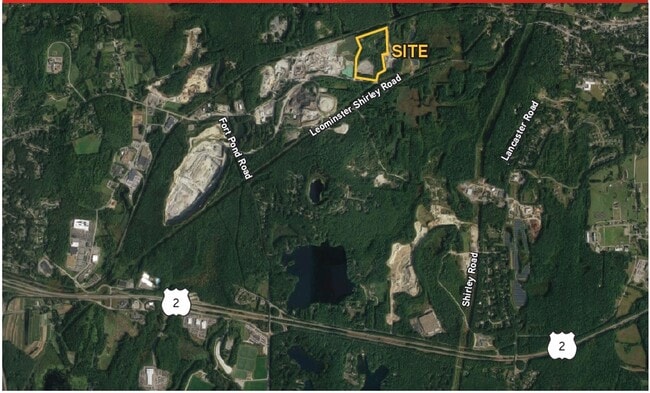
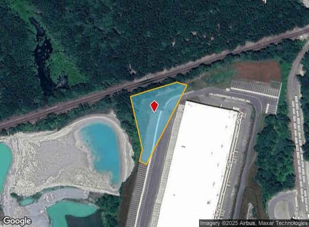
435R Leominster Shirley Rd, Lunenburg, MA 01462
NEARBY LISTINGS FOR SALE OR LEASE
Property Detail
435R Leominster Shirley Rd
LUNE-001430-000007
Worcester
Industrialacreage
Massachusetts
X
1.74 AC
25027C0291F
Fitchburg/Leominster
2025
Boston
2025
Worcester, MA-CT
712102
DEMOGRAPHICS near 435R Leominster Shirley Rd
1 Mile
3 Mile
5 Mile
2024 Total Population
810
13,761
61,673
2029 Population
813
13,723
61,411
Pop Growth 2024-2029
+ 0.37%
(0.28%)
(0.42%)
Average Age
43
43
42
2024 Total Households
280
4,409
23,742
HH Growth 2024-2029
+ 0.36%
(0.16%)
(0.43%)
Median Household Inc
$130,903
$114,135
$82,038
Avg Household Size
2.60
2.60
2.40
2024 Avg HH Vehicles
2.00
2.00
2.00
Median Home Value
$462,930
$398,971
$353,068
Median Year Built
1979
1973
1967
Nearby Places
Map Layers
Map Styles
 Street
 Aerial
- Restaurants
- Banks
- Shops
- Fitness
- Groceries
PUBLIC TRANSPORTATION
COMMUTER RAIL
Shirley (Fitchburg/South Acton Line - Massachusetts Bay Transportation Authority Commuter Rail (Purple Line))
DRIVE
WALK
Distance
Shirley (Fitchburg/South Acton Line - Massachusetts Bay Transportation Authority Commuter Rail (Purple Line))
8 min
3.3 mi
North Leominster (Fitchburg/South Acton Line - Massachusetts Bay Transportation Authority Commuter Rail (Purple Line))
DRIVE
WALK
Distance
North Leominster (Fitchburg/South Acton Line - Massachusetts Bay Transportation Authority Commuter Rail (Purple Line))
10 min
4.0 mi
AIRPORT
Worcester Regional
DRIVE
WALK
Distance
Worcester Regional
46 min
30.2 mi
Manchester Boston Regional
DRIVE
WALK
Distance
Manchester Boston Regional
70 min
38.7 mi
Freight Ports
Port of Boston
DRIVE
WALK
Distance
Port of Boston
70 min
43.9 mi
SALE & LEASE HISTORY
LISTING DATE
SALE/LEASE

Feb 12, 2020
For Sale
Nearby Properties
Address
Land Use
TOTAL SIZE
Lot Size
Zoning
Address
Land Use
TOTAL SIZE
Lot Size
Zoning
663,948 SF
516.30 AC
Address
Land Use
TOTAL SIZE
Lot Size
Zoning
97.47 AC
R1
Address
Land Use
TOTAL SIZE
Lot Size
Zoning
164,000 SF
11 AC
4
Address
Land Use
TOTAL SIZE
Lot Size
Zoning
109,921 SF
7.22 AC
21
Address
Land Use
TOTAL SIZE
Lot Size
Zoning
65.15 AC
Address
Land Use
TOTAL SIZE
Lot Size
Zoning
353,742 SF
34.89 AC
C
Address
Land Use
TOTAL SIZE
Lot Size
Zoning
372,000 SF
30.33 AC
Address
Land Use
TOTAL SIZE
Lot Size
Zoning
73,772 SF
36.70 AC
4
Address
Land Use
TOTAL SIZE
Lot Size
Zoning
140.95 AC
4
Address
Land Use
TOTAL SIZE
Lot Size
Zoning
85,000 SF
31.56 AC
R1
Address
Land Use
TOTAL SIZE
Lot Size
Zoning
150,372 SF
15.74 AC
21
Address
Land Use
TOTAL SIZE
Lot Size
Zoning
162,932 SF
19.12 AC
C
Address
Land Use
TOTAL SIZE
Lot Size
Zoning
125,461 SF
11.27 AC
Address
Land Use
TOTAL SIZE
Lot Size
Zoning
274,272 SF
50 AC
Address
Land Use
TOTAL SIZE
Lot Size
Zoning
Address
Land Use
TOTAL SIZE
Lot Size
Zoning
58,750 SF
7.77 AC
C
Address
Land Use
TOTAL SIZE
Lot Size
Zoning
88,566 SF
29.46 AC
Address
Land Use
TOTAL SIZE
Lot Size
Zoning
230,382 SF
10.67 AC
Address
Land Use
TOTAL SIZE
Lot Size
Zoning
97,048 SF
6.85 AC
Address
Land Use
TOTAL SIZE
Lot Size
Zoning
84,781 SF
8.48 AC
C
Address
Land Use
TOTAL SIZE
Lot Size
Zoning
90,480 SF
10.51 AC
21
Address
Land Use
TOTAL SIZE
Lot Size
Zoning
63,415 SF
10.33 AC
R2
Address
Land Use
TOTAL SIZE
Lot Size
Zoning
201,280 SF
9.66 AC
Address
Land Use
TOTAL SIZE
Lot Size
Zoning
187,000 SF
10.22 AC
21
Address
Land Use
TOTAL SIZE
Lot Size
Zoning
67,104 SF
Address
Land Use
TOTAL SIZE
Lot Size
Zoning
9.21 AC
R1
Address
Land Use
TOTAL SIZE
Lot Size
Zoning
142,184 SF
12.20 AC
Address
Land Use
TOTAL SIZE
Lot Size
Zoning
161,583 SF
19.34 AC
I
Address
Land Use
TOTAL SIZE
Lot Size
Zoning
35,142 SF
3.60 AC
23
Address
Land Use
TOTAL SIZE
Lot Size
Zoning
87,800 SF
57.40 AC
The World's #1 Commercial Real Estate Marketplace
Connect with us
© 2025 CoStar Group
The information above has been obtained from sources believed reliable. While we do not doubt its accuracy we have not verified it and make no guarantee, warranty or representation about it. It is your responsibility to independently confirm its accuracy and completeness. Any projections, opinions, assumptions, or estimates used are for example only and do not represent the current or future performance of the property. The value of this transaction to you depends on tax and other factors which should be evaluated by your tax, financial, and legal advisors. You and your advisors should conduct a careful, independent investigation of the property to determine to your satisfaction the suitability of the property for your needs.