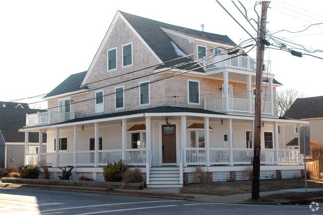
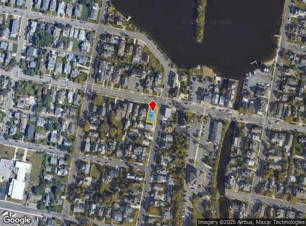
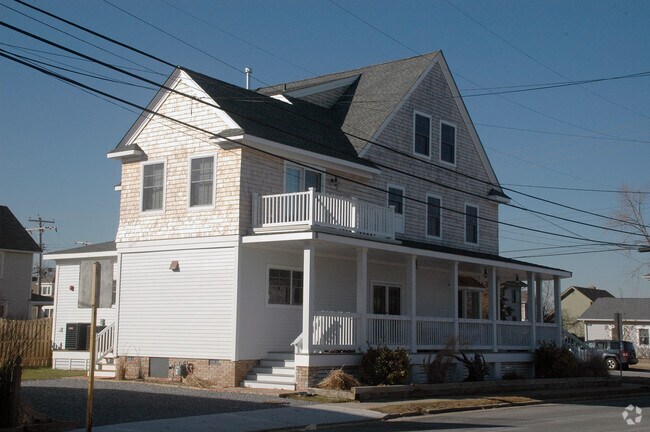
Property Record
436 Club Dr, Point Pleasant Beach, NJ 08742

NEARBY LISTINGS FOR SALE OR LEASE
Property Detail
436 Club Dr
New York-Jersey City-White Plains, NY-NJ
Amended Minor Subdivision
03-00045-0000-00013
50X100
Commercialnec
Ocean
X
New Jersey
34029C0208G
13
2024
0.12 AC
2025
Ocean County
711100
Northern New Jersey
4,016 SF
DEMOGRAPHICS near 436 Club Dr
1 Mile
3 Mile
5 Mile
2024 Total Population
7,777
43,275
107,052
2029 Population
8,647
46,502
113,789
Pop Growth 2024-2029
+ 11.19%
+ 7.46%
+ 6.29%
Average Age
46
43
44
2024 Total Households
3,356
17,394
43,008
HH Growth 2024-2029
+ 11.11%
+ 7.29%
+ 6.09%
Median Household Inc
$99,201
$110,534
$106,352
Avg Household Size
2.30
2.40
2.40
2024 Avg HH Vehicles
2.00
2.00
2.00
Median Home Value
$671,614
$475,593
$457,418
Median Year Built
1967
1965
1971
Nearby Places
Map Layers
Map Styles
 Street
 Aerial
- Restaurants
- Banks
- Shops
- Fitness
- Groceries
PUBLIC TRANSPORTATION
COMMUTER RAIL
Bay Head (North Jersey Coast Line - NJ Transit Commuter Rail (NJ Transit))
DRIVE
WALK
Distance
Bay Head (North Jersey Coast Line - NJ Transit Commuter Rail (NJ Transit))
1 min
12 min
0.6 mi
Point Pleasant Beach (North Jersey Coast Line - NJ Transit Commuter Rail (NJ Transit))
DRIVE
WALK
Distance
Point Pleasant Beach (North Jersey Coast Line - NJ Transit Commuter Rail (NJ Transit))
3 min
2.0 mi
Freight Ports
New York Container Terminal
DRIVE
WALK
Distance
New York Container Terminal
67 min
51.5 mi
Nearby Properties
Address
Land Use
TOTAL SIZE
Lot Size
Zoning
Address
Land Use
TOTAL SIZE
Lot Size
Zoning
50.10 AC
C
Address
Land Use
TOTAL SIZE
Lot Size
Zoning
117 AC
RR1
Address
Land Use
TOTAL SIZE
Lot Size
Zoning
21,850 SF
30.98 AC
R-1A
Address
Land Use
TOTAL SIZE
Lot Size
Zoning
5,000 SF
22.50 AC
R-4
Address
Land Use
TOTAL SIZE
Lot Size
Zoning
34,337 SF
99.30 AC
R-1
Address
Land Use
TOTAL SIZE
Lot Size
Zoning
3,792 SF
7.64 AC
R-1A
Address
Land Use
TOTAL SIZE
Lot Size
Zoning
10.52 AC
R-5
Address
Land Use
TOTAL SIZE
Lot Size
Zoning
63,136 SF
10.31 AC
R-1A
Address
Land Use
TOTAL SIZE
Lot Size
Zoning
18,058 SF
6.09 AC
R-50
Address
Land Use
TOTAL SIZE
Lot Size
Zoning
2,408 SF
4.84 AC
B-2
Address
Land Use
TOTAL SIZE
Lot Size
Zoning
75,697 SF
12.46 AC
R-3
Address
Land Use
TOTAL SIZE
Lot Size
Zoning
21 AC
ROS
Address
Land Use
TOTAL SIZE
Lot Size
Zoning
5,798 SF
1.10 AC
RC
Address
Land Use
TOTAL SIZE
Lot Size
Zoning
2.73 AC
RC
Address
Land Use
TOTAL SIZE
Lot Size
Zoning
40.43 AC
R-1
Address
Land Use
TOTAL SIZE
Lot Size
Zoning
17,450 SF
7.50 AC
HR
Address
Land Use
TOTAL SIZE
Lot Size
Zoning
1,140 SF
14 AC
GC
Address
Land Use
TOTAL SIZE
Lot Size
Zoning
1,976 SF
8.42 AC
R50
Address
Land Use
TOTAL SIZE
Lot Size
Zoning
1,702 SF
2.90 AC
C
Address
Land Use
TOTAL SIZE
Lot Size
Zoning
23,964 SF
4.55 AC
W
Address
Land Use
TOTAL SIZE
Lot Size
Zoning
3.05 AC
HC
Address
Land Use
TOTAL SIZE
Lot Size
Zoning
86,484 SF
7.25 AC
GC
Address
Land Use
TOTAL SIZE
Lot Size
Zoning
3,506 SF
1.29 AC
RC
Address
Land Use
TOTAL SIZE
Lot Size
Zoning
1,677 SF
3 AC
R-3A
Address
Land Use
TOTAL SIZE
Lot Size
Zoning
13.76 AC
RC
Address
Land Use
TOTAL SIZE
Lot Size
Zoning
10,003 SF
0.32 AC
PU
Address
Land Use
TOTAL SIZE
Lot Size
Zoning
18,240 SF
1.51 AC
RR3
Address
Land Use
TOTAL SIZE
Lot Size
Zoning
2,335 SF
3.17 AC
RC
Address
Land Use
TOTAL SIZE
Lot Size
Zoning
2.10 AC
ROS
Address
Land Use
TOTAL SIZE
Lot Size
Zoning
19,248 SF
5.75 AC
W
The World's #1 Commercial Real Estate Marketplace
Connect with us
© 2025 CoStar Group
The information above has been obtained from sources believed reliable. While we do not doubt its accuracy we have not verified it and make no guarantee, warranty or representation about it. It is your responsibility to independently confirm its accuracy and completeness. Any projections, opinions, assumptions, or estimates used are for example only and do not represent the current or future performance of the property. The value of this transaction to you depends on tax and other factors which should be evaluated by your tax, financial, and legal advisors. You and your advisors should conduct a careful, independent investigation of the property to determine to your satisfaction the suitability of the property for your needs.