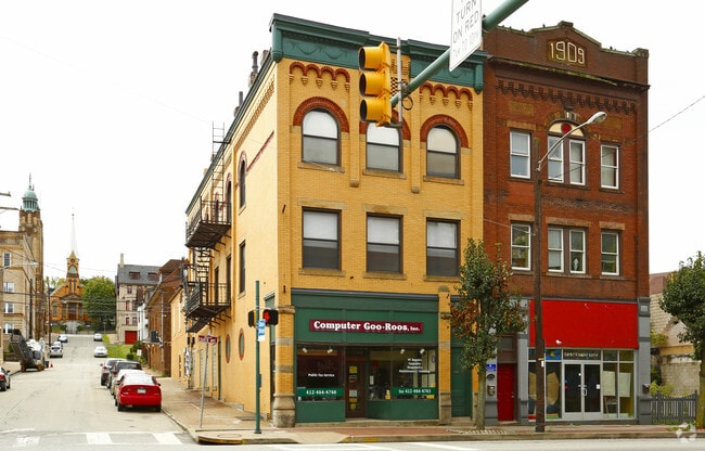
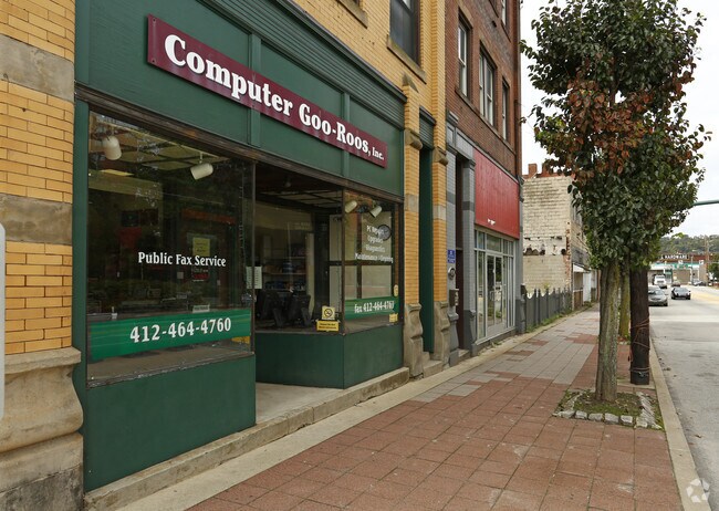
Property Record
436 E 8Th Ave, Homestead, PA 15120

NEARBY LISTINGS FOR SALE OR LEASE
Property Detail
436 E 8Th Ave
Pittsburgh, PA
City Farms Plan
0130-L-00299-0000-00
CITY FARMS PLAN 34 LOT 25X110-8TH AV 3 STY BRK BLDG 436
Retailwithmorethanonenonretailuse
Allegheny
X
Pennsylvania
42003C0367H
299
2024
0.06 AC
2025
South Pittsburgh/Rte 51
484300
Pittsburgh
DEMOGRAPHICS near 436 E 8Th Ave
1 mile
3 mile
5 mile
2024 Total Population
10,311
107,314
334,345
2029 Population
10,293
106,049
330,983
Pop Growth 2024-2029
(0.17%)
(1.18%)
(1.01%)
Average Age
43
41
40
2024 Total Households
4,973
49,284
154,025
HH Growth 2024-2029
(0.14%)
(1.29%)
(1.13%)
Median Household Inc
$40,871
$56,052
$49,953
Avg Household Size
2.00
2.10
2.00
2024 Avg HH Vehicles
1.00
1.00
1.00
Median Home Value
$130,014
$170,414
$150,976
Median Year Built
1954
1948
1950
Nearby Places
Map Layers
Map Styles
 Street
 Aerial
Transit
 Traffic
 Biking
Places
Listings with unknown addresses are not visible on the map
- Restaurants
- Banks
- Shops
- Fitness
- Groceries
PUBLIC TRANSPORTATION
COMMUTER RAIL
Drive
Walk
Distance
16 min
7.0 mi
AIRPORT
Pittsburgh International
Drive
Walk
Distance
Pittsburgh International
41 min
23.5 mi
Arnold Palmer Regional
Drive
Walk
Distance
Arnold Palmer Regional
62 min
33.3 mi
SALE & LEASE HISTORY
LISTING DATE
SALE/LEASE

Sep 23, 2016
For Sale
Nearby Properties
Address
Land Use
TOTAL SIZE
Lot Size
Zoning
Address
Land Use
TOTAL SIZE
Lot Size
Zoning
Address
Land Use
TOTAL SIZE
Lot Size
Zoning
1,950 SF
21.62 AC
Address
Land Use
TOTAL SIZE
Lot Size
Zoning
5.32 AC
Address
Land Use
TOTAL SIZE
Lot Size
Zoning
Address
Land Use
TOTAL SIZE
Lot Size
Zoning
7.79 AC
Address
Land Use
TOTAL SIZE
Lot Size
Zoning
15.90 AC
Address
Land Use
TOTAL SIZE
Lot Size
Zoning
4.49 AC
Address
Land Use
TOTAL SIZE
Lot Size
Zoning
16.49 AC
Address
Land Use
TOTAL SIZE
Lot Size
Zoning
Address
Land Use
TOTAL SIZE
Lot Size
Zoning
9.69 AC
Address
Land Use
TOTAL SIZE
Lot Size
Zoning
23.87 AC
Address
Land Use
TOTAL SIZE
Lot Size
Zoning
Address
Land Use
TOTAL SIZE
Lot Size
Zoning
162.82 AC
Address
Land Use
TOTAL SIZE
Lot Size
Zoning
2.92 AC
Address
Land Use
TOTAL SIZE
Lot Size
Zoning
0.93 AC
Address
Land Use
TOTAL SIZE
Lot Size
Zoning
19.85 AC
Address
Land Use
TOTAL SIZE
Lot Size
Zoning
121.64 AC
Address
Land Use
TOTAL SIZE
Lot Size
Zoning
Address
Land Use
TOTAL SIZE
Lot Size
Zoning
Address
Land Use
TOTAL SIZE
Lot Size
Zoning
Address
Land Use
TOTAL SIZE
Lot Size
Zoning
14.79 AC
Address
Land Use
TOTAL SIZE
Lot Size
Zoning
12.51 AC
Address
Land Use
TOTAL SIZE
Lot Size
Zoning
Address
Land Use
TOTAL SIZE
Lot Size
Zoning
17.52 AC
Address
Land Use
TOTAL SIZE
Lot Size
Zoning
180.92 AC
Address
Land Use
TOTAL SIZE
Lot Size
Zoning
19.54 AC
Address
Land Use
TOTAL SIZE
Lot Size
Zoning
Address
Land Use
TOTAL SIZE
Lot Size
Zoning
1.48 AC
Address
Land Use
TOTAL SIZE
Lot Size
Zoning
48.07 AC
Address
Land Use
TOTAL SIZE
Lot Size
Zoning
3.54 AC
The World's #1 Commercial Real Estate Marketplace
Connect with us
© 2026 CoStar Group
The information above has been obtained from sources believed reliable. While we do not doubt its accuracy we have not verified it and make no guarantee, warranty or representation about it. It is your responsibility to independently confirm its accuracy and completeness. Any projections, opinions, assumptions, or estimates used are for example only and do not represent the current or future performance of the property. The value of this transaction to you depends on tax and other factors which should be evaluated by your tax, financial, and legal advisors. You and your advisors should conduct a careful, independent investigation of the property to determine to your satisfaction the suitability of the property for your needs.