Property Record
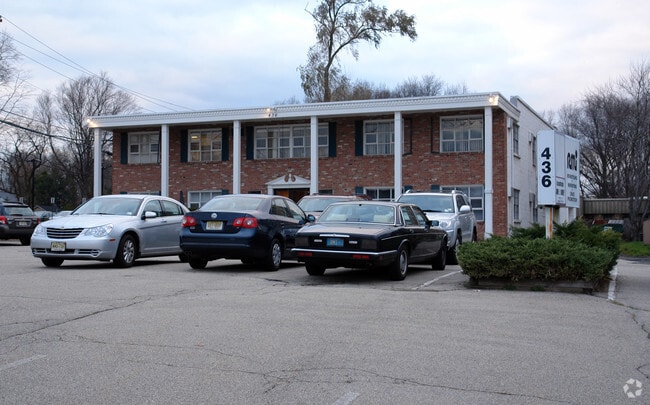
436 Old Hook Rd, Emerson, NJ 07630


This Property Is For Sale
NEARBY LISTINGS FOR SALE OR LEASE
Property Detail
436 Old Hook Rd
14-01101-0000-00005-04
100X240 4LT
Commercialnec
Bergen
X
New Jersey
34003C0182H
5.4
2024
0.55 AC
2025
North Central Bergen
014000
Northern New Jersey
11,036 SF
New York-Jersey City-White Plains, NY-NJ
DEMOGRAPHICS near 436 Old Hook Rd
1 Mile
3 Mile
5 Mile
2024 Total Population
7,227
94,260
258,950
2029 Population
7,209
94,083
258,429
Pop Growth 2024-2029
(0.25%)
(0.19%)
(0.20%)
Average Age
43
43
42
2024 Total Households
2,655
32,785
88,008
HH Growth 2024-2029
(0.30%)
(0.27%)
(0.26%)
Median Household Inc
$131,617
$139,170
$135,438
Avg Household Size
2.70
2.80
2.90
2024 Avg HH Vehicles
2.00
2.00
2.00
Median Home Value
$617,536
$634,763
$658,523
Median Year Built
1965
1957
1958
Nearby Places
Map Layers
Map Styles
 Street
 Aerial
- Restaurants
- Banks
- Shops
- Fitness
- Groceries
PUBLIC TRANSPORTATION
COMMUTER RAIL
Westwood (Pascack Valley Line - NJ Transit Commuter Rail (NJ Transit))
DRIVE
WALK
Distance
Westwood (Pascack Valley Line - NJ Transit Commuter Rail (NJ Transit))
3 min
1.6 mi
Emerson (Pascack Valley Line - NJ Transit Commuter Rail (NJ Transit))
DRIVE
WALK
Distance
Emerson (Pascack Valley Line - NJ Transit Commuter Rail (NJ Transit))
4 min
1.9 mi
AIRPORT
LaGuardia
DRIVE
WALK
Distance
LaGuardia
37 min
22.5 mi
Newark Liberty International
DRIVE
WALK
Distance
Newark Liberty International
32 min
25.1 mi
Westchester County
DRIVE
WALK
Distance
Westchester County
43 min
28.4 mi
Freight Ports
NY - Red Hook Container Terminal
DRIVE
WALK
Distance
NY - Red Hook Container Terminal
46 min
27.3 mi
Nearby Properties
Address
Land Use
TOTAL SIZE
Lot Size
Zoning
Address
Land Use
TOTAL SIZE
Lot Size
Zoning
19.96 AC
HSO
Address
Land Use
TOTAL SIZE
Lot Size
Zoning
4,000 SF
14.69 AC
Address
Land Use
TOTAL SIZE
Lot Size
Zoning
8.78 AC
HSO
Address
Land Use
TOTAL SIZE
Lot Size
Zoning
59 AC
AA
Address
Land Use
TOTAL SIZE
Lot Size
Zoning
185,878 SF
33.44 AC
B
Address
Land Use
TOTAL SIZE
Lot Size
Zoning
23,572 SF
98.75 AC
CR
Address
Land Use
TOTAL SIZE
Lot Size
Zoning
9.20 AC
OR
Address
Land Use
TOTAL SIZE
Lot Size
Zoning
47,623 SF
88.60 AC
B
Address
Land Use
TOTAL SIZE
Lot Size
Zoning
82.73 AC
Address
Land Use
TOTAL SIZE
Lot Size
Zoning
21.74 AC
SC
Address
Land Use
TOTAL SIZE
Lot Size
Zoning
Address
Land Use
TOTAL SIZE
Lot Size
Zoning
0.78 AC
B
Address
Land Use
TOTAL SIZE
Lot Size
Zoning
8.72 AC
A
Address
Land Use
TOTAL SIZE
Lot Size
Zoning
1,620 SF
37.22 AC
R225
Address
Land Use
TOTAL SIZE
Lot Size
Zoning
845.02 AC
Address
Land Use
TOTAL SIZE
Lot Size
Zoning
9.44 AC
RESA
Address
Land Use
TOTAL SIZE
Lot Size
Zoning
3.33 AC
R3
Address
Land Use
TOTAL SIZE
Lot Size
Zoning
5.37 AC
B2
Address
Land Use
TOTAL SIZE
Lot Size
Zoning
15,065 SF
9.30 AC
RC
Address
Land Use
TOTAL SIZE
Lot Size
Zoning
191,950 SF
43.03 AC
RA25
Address
Land Use
TOTAL SIZE
Lot Size
Zoning
62,728 SF
14.49 AC
RA15
Address
Land Use
TOTAL SIZE
Lot Size
Zoning
5.17 AC
B2
Address
Land Use
TOTAL SIZE
Lot Size
Zoning
4 AC
HSO
Address
Land Use
TOTAL SIZE
Lot Size
Zoning
144,751 SF
22.87 AC
RA
Address
Land Use
TOTAL SIZE
Lot Size
Zoning
440 SF
98.43 AC
EO
Address
Land Use
TOTAL SIZE
Lot Size
Zoning
40.47 AC
DISTRICTN
Address
Land Use
TOTAL SIZE
Lot Size
Zoning
9.70 AC
Address
Land Use
TOTAL SIZE
Lot Size
Zoning
41,552 SF
115.62 AC
A-1
Address
Land Use
TOTAL SIZE
Lot Size
Zoning
10.91 AC
RA
Address
Land Use
TOTAL SIZE
Lot Size
Zoning
8.50 AC
A
The World's #1 Commercial Real Estate Marketplace
Connect with us
© 2026 CoStar Group
The information above has been obtained from sources believed reliable. While we do not doubt its accuracy we have not verified it and make no guarantee, warranty or representation about it. It is your responsibility to independently confirm its accuracy and completeness. Any projections, opinions, assumptions, or estimates used are for example only and do not represent the current or future performance of the property. The value of this transaction to you depends on tax and other factors which should be evaluated by your tax, financial, and legal advisors. You and your advisors should conduct a careful, independent investigation of the property to determine to your satisfaction the suitability of the property for your needs.