Property Record
436 Parker St, Springfield, MA 01129
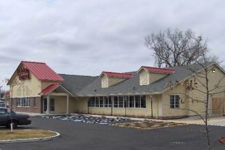
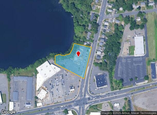
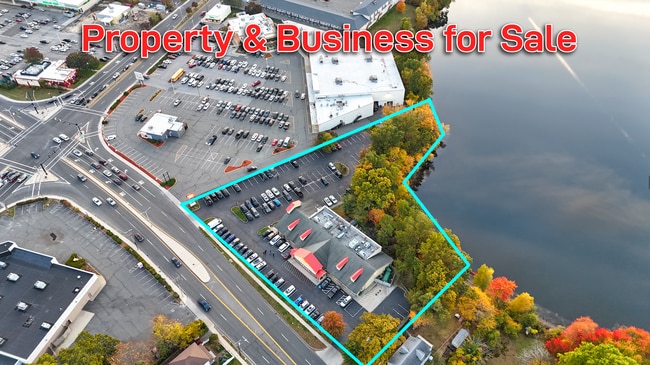
This Property Is For Sale
NEARBY LISTINGS FOR SALE OR LEASE
Property Detail
436 Parker St
SPRI-009510-000000-000215
Springfield
Restaurantbuilding
Hampden
A
Massachusetts
25013C0240E
2.05 AC
2025
Hampden County
2025
Hartford
801503
Springfield, MA
10,020 SF
DEMOGRAPHICS near 436 Parker St
1 mile
3 mile
5 mile
2024 Total Population
10,125
62,149
168,739
2029 Population
9,971
61,310
165,976
Pop Growth 2024-2029
(1.52%)
(1.35%)
(1.64%)
Average Age
38
41
40
2024 Total Households
4,005
24,342
63,944
HH Growth 2024-2029
(1.60%)
(1.42%)
(1.68%)
Median Household Inc
$52,274
$62,922
$59,798
Avg Household Size
2.50
2.40
2.50
2024 Avg HH Vehicles
2.00
2.00
2.00
Median Home Value
$188,576
$230,017
$232,552
Median Year Built
1961
1959
1956
Nearby Places
Map Layers
Map Styles
 Street
 Aerial
Transit
 Traffic
 Biking
Places
Listings with unknown addresses are not visible on the map
- Restaurants
- Banks
- Shops
- Fitness
- Groceries
PUBLIC TRANSPORTATION
COMMUTER RAIL
Drive
Walk
Distance
12 min
6.4 mi
Drive
Walk
Distance
17 min
9.5 mi
AIRPORT
Bradley International
Drive
Walk
Distance
Bradley International
42 min
19.7 mi
Worcester Regional
Drive
Walk
Distance
Worcester Regional
67 min
46.5 mi
Nearby Properties
Address
Land Use
TOTAL SIZE
Lot Size
Zoning
Address
Land Use
TOTAL SIZE
Lot Size
Zoning
89,312 SF
38.72 AC
R1
Address
Land Use
TOTAL SIZE
Lot Size
Zoning
263,462 SF
21.65 AC
R2
Address
Land Use
TOTAL SIZE
Lot Size
Zoning
56,576 SF
62.84 AC
SR1R4
Address
Land Use
TOTAL SIZE
Lot Size
Zoning
7.41 AC
I2
Address
Land Use
TOTAL SIZE
Lot Size
Zoning
45,444 SF
13.80 AC
Address
Land Use
TOTAL SIZE
Lot Size
Zoning
131,942 SF
40.30 AC
R1
Address
Land Use
TOTAL SIZE
Lot Size
Zoning
36,446 SF
25 AC
R1
Address
Land Use
TOTAL SIZE
Lot Size
Zoning
153,742 SF
22.34 AC
R1
Address
Land Use
TOTAL SIZE
Lot Size
Zoning
181,000 SF
34.48 AC
I1
Address
Land Use
TOTAL SIZE
Lot Size
Zoning
60.25 AC
Address
Land Use
TOTAL SIZE
Lot Size
Zoning
39,776 SF
8.16 AC
R2
Address
Land Use
TOTAL SIZE
Lot Size
Zoning
102,932 SF
60.01 AC
R6
Address
Land Use
TOTAL SIZE
Lot Size
Zoning
94,076 SF
63.12 AC
Address
Land Use
TOTAL SIZE
Lot Size
Zoning
105,000 SF
17.59 AC
SR1R3
Address
Land Use
TOTAL SIZE
Lot Size
Zoning
71,911 SF
9.19 AC
Address
Land Use
TOTAL SIZE
Lot Size
Zoning
762,340 SF
76.18 AC
SR1R2I
Address
Land Use
TOTAL SIZE
Lot Size
Zoning
99,792 SF
123.26 AC
S
Address
Land Use
TOTAL SIZE
Lot Size
Zoning
215,776 SF
28.52 AC
I1
Address
Land Use
TOTAL SIZE
Lot Size
Zoning
62,115 SF
1.69 AC
R1
Address
Land Use
TOTAL SIZE
Lot Size
Zoning
136,326 SF
65.19 AC
Address
Land Use
TOTAL SIZE
Lot Size
Zoning
15.31 AC
GB
Address
Land Use
TOTAL SIZE
Lot Size
Zoning
6.81 AC
S
Address
Land Use
TOTAL SIZE
Lot Size
Zoning
67,500 SF
14.55 AC
I1
Address
Land Use
TOTAL SIZE
Lot Size
Zoning
49,431 SF
6.19 AC
SR1B1
Address
Land Use
TOTAL SIZE
Lot Size
Zoning
34,732 SF
24.73 AC
R1
Address
Land Use
TOTAL SIZE
Lot Size
Zoning
3,534 SF
38.61 AC
R-3
Address
Land Use
TOTAL SIZE
Lot Size
Zoning
47,458 SF
3.87 AC
R1
Address
Land Use
TOTAL SIZE
Lot Size
Zoning
139,292 SF
12.54 AC
SB1I2
Address
Land Use
TOTAL SIZE
Lot Size
Zoning
18,774 SF
11.79 AC
S
Address
Land Use
TOTAL SIZE
Lot Size
Zoning
34.44 AC
I
The World's #1 Commercial Real Estate Marketplace
Connect with us
© 2026 CoStar Group
The information above has been obtained from sources believed reliable. While we do not doubt its accuracy we have not verified it and make no guarantee, warranty or representation about it. It is your responsibility to independently confirm its accuracy and completeness. Any projections, opinions, assumptions, or estimates used are for example only and do not represent the current or future performance of the property. The value of this transaction to you depends on tax and other factors which should be evaluated by your tax, financial, and legal advisors. You and your advisors should conduct a careful, independent investigation of the property to determine to your satisfaction the suitability of the property for your needs.