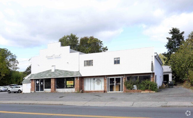
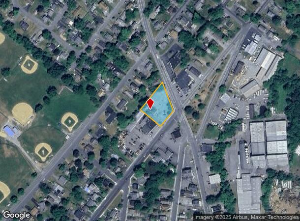
Property Record
436 Route 17M, Middletown, NY 10940

NEARBY LISTINGS FOR SALE OR LEASE
Property Detail
436 Route 17M
335200-039-000-0013-003.000-0000
LTS 14 15 16 BLK P CENT
Supermarket
Orange
X
New York
36071C0258E
3.000
2024
0.37 AC
2024
Middletown
011301
Northern New Jersey
2,100 SF
New York-Jersey City-White Plains, NY-NJ
DEMOGRAPHICS near 436 Route 17M
1 Mile
3 Mile
5 Mile
2024 Total Population
13,632
51,203
66,362
2029 Population
13,791
52,142
67,582
Pop Growth 2024-2029
+ 1.17%
+ 1.83%
+ 1.84%
Average Age
39
39
40
2024 Total Households
4,949
18,922
24,231
HH Growth 2024-2029
+ 1.23%
+ 1.98%
+ 2.00%
Median Household Inc
$74,001
$75,163
$79,447
Avg Household Size
2.60
2.60
2.60
2024 Avg HH Vehicles
2.00
2.00
2.00
Median Home Value
$272,380
$253,004
$270,315
Median Year Built
1964
1973
1975
Nearby Places
- Restaurants
- Banks
- Shops
- Fitness
- Groceries
PUBLIC TRANSPORTATION
COMMUTER RAIL
Middletown New York (Bergen County/Port Jervis Line - NJ Transit Commuter Rail (NJ Transit), Main/Port Jervis Line - NJ Transit Commuter Rail (NJ Transit))
DRIVE
WALK
Distance
Middletown New York (Bergen County/Port Jervis Line - NJ Transit Commuter Rail (NJ Transit), Main/Port Jervis Line - NJ Transit Commuter Rail (NJ Transit))
8 min
3.2 mi
Otisville (Bergen County/Port Jervis Line - NJ Transit Commuter Rail (NJ Transit), Main/Port Jervis Line - NJ Transit Commuter Rail (NJ Transit))
DRIVE
WALK
Distance
Otisville (Bergen County/Port Jervis Line - NJ Transit Commuter Rail (NJ Transit), Main/Port Jervis Line - NJ Transit Commuter Rail (NJ Transit))
12 min
8.3 mi
AIRPORT
New York Stewart International
DRIVE
WALK
Distance
New York Stewart International
33 min
24.1 mi
Freight Ports
Port Newark Container Terminal
DRIVE
WALK
Distance
Port Newark Container Terminal
96 min
72.5 mi
SALE & LEASE HISTORY
LISTING DATE
SALE/LEASE

Sep 29, 2017
For Lease
Nearby Properties
Address
Land Use
TOTAL SIZE
Lot Size
Zoning
Address
Land Use
TOTAL SIZE
Lot Size
Zoning
275,216 SF
58.40 AC
O/R
Address
Land Use
TOTAL SIZE
Lot Size
Zoning
Address
Land Use
TOTAL SIZE
Lot Size
Zoning
40.40 AC
I-2
Address
Land Use
TOTAL SIZE
Lot Size
Zoning
698,289 SF
52.20 AC
Address
Land Use
TOTAL SIZE
Lot Size
Zoning
180,840 SF
37.50 AC
TC
Address
Land Use
TOTAL SIZE
Lot Size
Zoning
24.40 AC
R-1
Address
Land Use
TOTAL SIZE
Lot Size
Zoning
376,002 SF
34.40 AC
TC
Address
Land Use
TOTAL SIZE
Lot Size
Zoning
17.60 AC
R-1
Address
Land Use
TOTAL SIZE
Lot Size
Zoning
Address
Land Use
TOTAL SIZE
Lot Size
Zoning
14.70 AC
MC 1
Address
Land Use
TOTAL SIZE
Lot Size
Zoning
142,416 SF
13.90 AC
R1
Address
Land Use
TOTAL SIZE
Lot Size
Zoning
289,910 SF
19.90 AC
TC
Address
Land Use
TOTAL SIZE
Lot Size
Zoning
1,360 SF
6.30 AC
Address
Land Use
TOTAL SIZE
Lot Size
Zoning
270,471 SF
78.40 AC
R1
Address
Land Use
TOTAL SIZE
Lot Size
Zoning
5,753 SF
18 AC
TC
Address
Land Use
TOTAL SIZE
Lot Size
Zoning
125,616 SF
11.50 AC
O/R
Address
Land Use
TOTAL SIZE
Lot Size
Zoning
208,464 SF
24.90 AC
HC
Address
Land Use
TOTAL SIZE
Lot Size
Zoning
141,454 SF
12 AC
TC
Address
Land Use
TOTAL SIZE
Lot Size
Zoning
7 AC
C-3
Address
Land Use
TOTAL SIZE
Lot Size
Zoning
6.80 AC
MC 1
Address
Land Use
TOTAL SIZE
Lot Size
Zoning
83,832 SF
4.20 AC
TC
Address
Land Use
TOTAL SIZE
Lot Size
Zoning
96,231 SF
14.80 AC
HC
Address
Land Use
TOTAL SIZE
Lot Size
Zoning
71,031 SF
7.30 AC
TC
Address
Land Use
TOTAL SIZE
Lot Size
Zoning
53,964 SF
4.50 AC
O/R
Address
Land Use
TOTAL SIZE
Lot Size
Zoning
87,090 SF
4.50 AC
TC
Address
Land Use
TOTAL SIZE
Lot Size
Zoning
123,336 SF
6.30 AC
TC
Address
Land Use
TOTAL SIZE
Lot Size
Zoning
312,196 SF
18.60 AC
ENT-L
Address
Land Use
TOTAL SIZE
Lot Size
Zoning
57.40 AC
MC 1
Address
Land Use
TOTAL SIZE
Lot Size
Zoning
59,736 SF
6.10 AC
TC
Address
Land Use
TOTAL SIZE
Lot Size
Zoning
82,295 SF
7.30 AC
The World's #1 Commercial Real Estate Marketplace
Connect with us
© 2025 CoStar Group
The information above has been obtained from sources believed reliable. While we do not doubt its accuracy we have not verified it and make no guarantee, warranty or representation about it. It is your responsibility to independently confirm its accuracy and completeness. Any projections, opinions, assumptions, or estimates used are for example only and do not represent the current or future performance of the property. The value of this transaction to you depends on tax and other factors which should be evaluated by your tax, financial, and legal advisors. You and your advisors should conduct a careful, independent investigation of the property to determine to your satisfaction the suitability of the property for your needs.