Property Record
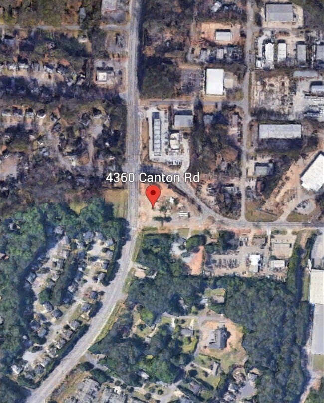
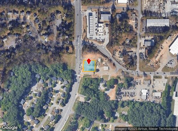
4360 Canton Rd, Marietta, GA 30066
This Property Is For Sale
NEARBY LISTINGS FOR SALE OR LEASE
Property Detail
4360 Canton Rd
Atlanta-Sandy Springs-Roswell, GA
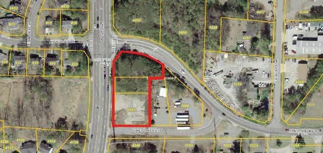
ALL THAT TRACT OR PARCEL OF LAND LYING AND BEING IN THE 16TH DISTRICT, 2ND SECTION, COBB COUNTY, GEORGIA, LYING WITHIN LAND LOT 157, IDENTIFIED AS TAX PARCEL 65, ON THE FIELD MAP
16-0157-0-065-0
Cobb
Commercialacreage
Georgia
X
157
13057C0350E
0.67 AC
2025
East Cobb
2025
Atlanta
030363
DEMOGRAPHICS near 4360 Canton Rd
1 Mile
3 Mile
5 Mile
2024 Total Population
5,619
66,313
194,862
2029 Population
5,653
69,653
206,890
Pop Growth 2024-2029
+ 0.61%
+ 5.04%
+ 6.17%
Average Age
40
41
39
2024 Total Households
2,013
24,630
72,327
HH Growth 2024-2029
+ 0.50%
+ 5.55%
+ 6.40%
Median Household Inc
$97,215
$99,088
$96,560
Avg Household Size
2.70
2.60
2.60
2024 Avg HH Vehicles
2.00
2.00
2.00
Median Home Value
$269,956
$322,257
$333,153
Median Year Built
1981
1987
1991
Nearby Places
- Restaurants
- Banks
- Shops
- Fitness
- Groceries
PUBLIC TRANSPORTATION
AIRPORT
Hartsfield - Jackson Atlanta International
DRIVE
WALK
Distance
Hartsfield - Jackson Atlanta International
49 min
35.0 mi
Freight Ports
Georgia Ports - Savannah
DRIVE
WALK
Distance
Georgia Ports - Savannah
311 min
274.3 mi
Nearby Properties
Address
Land Use
TOTAL SIZE
Lot Size
Zoning
Address
Land Use
TOTAL SIZE
Lot Size
Zoning
228,644 SF
7.88 AC
DT-CBD
Address
Land Use
TOTAL SIZE
Lot Size
Zoning
197,890 SF
14.60 AC
R-4
Address
Land Use
TOTAL SIZE
Lot Size
Zoning
181,704 SF
17.56 AC
DT-MRA
Address
Land Use
TOTAL SIZE
Lot Size
Zoning
128,196 SF
24.68 AC
R-4
Address
Land Use
TOTAL SIZE
Lot Size
Zoning
266,487 SF
21.69 AC
R-4
Address
Land Use
TOTAL SIZE
Lot Size
Zoning
235,861 SF
31.92 AC
RM10
Address
Land Use
TOTAL SIZE
Lot Size
Zoning
27.25 AC
OS
Address
Land Use
TOTAL SIZE
Lot Size
Zoning
232,415 SF
19.23 AC
RM-12
Address
Land Use
TOTAL SIZE
Lot Size
Zoning
229,440 SF
13 AC
OI
Address
Land Use
TOTAL SIZE
Lot Size
Zoning
113,849 SF
7.46 AC
R-5
Address
Land Use
TOTAL SIZE
Lot Size
Zoning
182,971 SF
11.28 AC
OS
Address
Land Use
TOTAL SIZE
Lot Size
Zoning
85,166 SF
3.41 AC
DT-CBD
Address
Land Use
TOTAL SIZE
Lot Size
Zoning
27.18 AC
O&I/R-20
Address
Land Use
TOTAL SIZE
Lot Size
Zoning
186,090 SF
30.08 AC
GC
Address
Land Use
TOTAL SIZE
Lot Size
Zoning
63,264 SF
8 AC
PUD
Address
Land Use
TOTAL SIZE
Lot Size
Zoning
132,022 SF
12.69 AC
GC
Address
Land Use
TOTAL SIZE
Lot Size
Zoning
5.46 AC
RSL
Address
Land Use
TOTAL SIZE
Lot Size
Zoning
86,307 SF
13.49 AC
GC
Address
Land Use
TOTAL SIZE
Lot Size
Zoning
68,012 SF
5.56 AC
UVC
Address
Land Use
TOTAL SIZE
Lot Size
Zoning
346,544 SF
16.28 AC
OS
Address
Land Use
TOTAL SIZE
Lot Size
Zoning
61,433 SF
9.52 AC
GC
Address
Land Use
TOTAL SIZE
Lot Size
Zoning
93,120 SF
14.84 AC
NRC
Address
Land Use
TOTAL SIZE
Lot Size
Zoning
72,376 SF
12.25 AC
GC
Address
Land Use
TOTAL SIZE
Lot Size
Zoning
115,107 SF
12.90 AC
NRC/NS
Address
Land Use
TOTAL SIZE
Lot Size
Zoning
135,538 SF
12.34 AC
DT-CMU
Address
Land Use
TOTAL SIZE
Lot Size
Zoning
88,086 SF
5.19 AC
GC
Address
Land Use
TOTAL SIZE
Lot Size
Zoning
138,918 SF
13.96 AC
GC
Address
Land Use
TOTAL SIZE
Lot Size
Zoning
166,724 SF
11.81 AC
OS
Address
Land Use
TOTAL SIZE
Lot Size
Zoning
88,086 SF
5.50 AC
GC/WS
Address
Land Use
TOTAL SIZE
Lot Size
Zoning
1,284 SF
3.04 AC
RSL
The World's #1 Commercial Real Estate Marketplace
Connect with us
© 2025 CoStar Group
The information above has been obtained from sources believed reliable. While we do not doubt its accuracy we have not verified it and make no guarantee, warranty or representation about it. It is your responsibility to independently confirm its accuracy and completeness. Any projections, opinions, assumptions, or estimates used are for example only and do not represent the current or future performance of the property. The value of this transaction to you depends on tax and other factors which should be evaluated by your tax, financial, and legal advisors. You and your advisors should conduct a careful, independent investigation of the property to determine to your satisfaction the suitability of the property for your needs.