Property Record
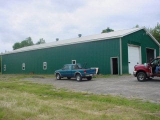
4360 State Route 11, Malone, NY 12953

Property Detail
4360 State Route 11
164889-085-000-0002-016-400-0000
OTIS RR RR ROAD
Warehouse
Franklin
01 - NOT Z
New York
2025
16.400
2025
7.37 AC
951400
Malone
4,400 SF
Other Market Areas
NEARBY LISTINGS FOR SALE OR LEASE
-
-
View all Malone listings for sale on LoopNet.com
DEMOGRAPHICS near 4360 State Route 11
1 mile
3 mile
5 mile
2025 Total Population
202
4,948
12,113
2030 Population
197
4,882
12,007
Pop Growth 2025-2030
(2.48%)
(1.33%)
(0.88%)
Average Age
43
43
42
2025 Total Households
85
1,497
4,219
HH Growth 2025-2030
(2.35%)
(1.40%)
(0.88%)
Median Household Inc
$104,762
$79,012
$60,919
Avg Household Size
2.30
2.30
2.20
2025 Avg HH Vehicles
2.00
2.00
2.00
Median Home Value
$163,999
$150,127
$135,675
Median Year Built
1985
1963
1961
Nearby Places
Map Layers
Map Styles
 Street
 Aerial
Layers
 Traffic
 Biking
Places
Listings with unknown addresses are not visible on the map
- Restaurants
- Banks
- Shops
- Fitness
- Groceries
Nearby Properties
Address
Land Use
TOTAL SIZE
Lot Size
Zoning
Address
Land Use
TOTAL SIZE
Lot Size
Zoning
5,000 SF
39 AC
01 - NOT Z
Address
Land Use
TOTAL SIZE
Lot Size
Zoning
72,732 SF
10.32 AC
01 - NOT Z
Address
Land Use
TOTAL SIZE
Lot Size
Zoning
28,908 SF
10 AC
01 - NOT Z
Address
Land Use
TOTAL SIZE
Lot Size
Zoning
5,910 SF
22.16 AC
01 - NOT Z
Address
Land Use
TOTAL SIZE
Lot Size
Zoning
34,548 SF
5.16 AC
01 - NOT Z
Address
Land Use
TOTAL SIZE
Lot Size
Zoning
2,157 SF
4.95 AC
01 - NOT Z
Address
Land Use
TOTAL SIZE
Lot Size
Zoning
22,036 SF
3.15 AC
01 - NOT Z
Address
Land Use
TOTAL SIZE
Lot Size
Zoning
16,594 SF
7.09 AC
01 - NOT Z
Address
Land Use
TOTAL SIZE
Lot Size
Zoning
1,823 SF
99.10 AC
01 - NOT Z
Address
Land Use
TOTAL SIZE
Lot Size
Zoning
23,640 SF
8.17 AC
01 - NOT Z
Address
Land Use
TOTAL SIZE
Lot Size
Zoning
8,762 SF
0.34 AC
01 - NOT Z
Address
Land Use
TOTAL SIZE
Lot Size
Zoning
17,680 SF
1.94 AC
01 - NOT Z
Address
Land Use
TOTAL SIZE
Lot Size
Zoning
1,902 SF
40.77 AC
01 - NOT Z
Address
Land Use
TOTAL SIZE
Lot Size
Zoning
5,642 SF
0.68 AC
01 - NOT Z
Address
Land Use
TOTAL SIZE
Lot Size
Zoning
5,642 SF
0.02 AC
01 - NOT Z
Address
Land Use
TOTAL SIZE
Lot Size
Zoning
4,498 SF
5.74 AC
01 - NOT Z
Address
Land Use
TOTAL SIZE
Lot Size
Zoning
17,300 SF
6.49 AC
01 - NOT Z
Address
Land Use
TOTAL SIZE
Lot Size
Zoning
11,672 SF
0.63 AC
01 - NOT Z
Address
Land Use
TOTAL SIZE
Lot Size
Zoning
15,543 SF
0.77 AC
01 - NOT Z
Address
Land Use
TOTAL SIZE
Lot Size
Zoning
9,498 SF
4.40 AC
01 - NOT Z
Address
Land Use
TOTAL SIZE
Lot Size
Zoning
12,148 SF
15.12 AC
01 - NOT Z
Address
Land Use
TOTAL SIZE
Lot Size
Zoning
2,800 SF
10.07 AC
01 - NOT Z
Address
Land Use
TOTAL SIZE
Lot Size
Zoning
4,479 SF
1.84 AC
01 - NOT Z
Address
Land Use
TOTAL SIZE
Lot Size
Zoning
4,468 SF
4.70 AC
01 - NOT Z
Address
Land Use
TOTAL SIZE
Lot Size
Zoning
1 AC
08 - GOVER
Address
Land Use
TOTAL SIZE
Lot Size
Zoning
3,205 SF
1.05 AC
01 - NOT Z
Address
Land Use
TOTAL SIZE
Lot Size
Zoning
61,520 SF
41.85 AC
01 - NOT Z
Address
Land Use
TOTAL SIZE
Lot Size
Zoning
5,635 SF
0.35 AC
01 - NOT Z
Address
Land Use
TOTAL SIZE
Lot Size
Zoning
612 SF
5.08 AC
01 - NOT Z
Address
Land Use
TOTAL SIZE
Lot Size
Zoning
12,012 SF
0.53 AC
01 - NOT Z
The World's #1 Commercial Real Estate Marketplace
Connect with us
© 2026 CoStar Group
The information above has been obtained from sources believed reliable. While we do not doubt its accuracy we have not verified it and make no guarantee, warranty or representation about it. It is your responsibility to independently confirm its accuracy and completeness. Any projections, opinions, assumptions, or estimates used are for example only and do not represent the current or future performance of the property. The value of this transaction to you depends on tax and other factors which should be evaluated by your tax, financial, and legal advisors. You and your advisors should conduct a careful, independent investigation of the property to determine to your satisfaction the suitability of the property for your needs.