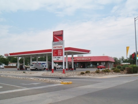
Property Record
437 32 Rd, Grand Junction, CO 81504

Property Detail
437 32 Rd
2943-154-50-005
LOT 5 BLK 4 MIDLANDS VILLAGE FIL NO ONE SEC 15 1S 1E & AN UND INT IN OUTLOT A-B & C OPEN SPACE & THAT PT OF OUTLOT D OPEN SPACE LYG IN CLIFTON SANITATION NO 2 & PRIVATE RDS - 1.49AC
Commercialnec
MESA
PD
Colorado
B and X Area of moderate flood hazard, usually the area between the limits of the 100-year and 500-year floods.
5
2023
1.49 AC
2024
Colorado Northwest Area
001102
Other Market Areas
6,030 SF
Grand Junction, CO
NEARBY LISTINGS FOR SALE OR LEASE
DEMOGRAPHICS near 437 32 Rd
1 mile
3 mile
5 mile
2025 Total Population
13,068
43,369
78,527
2030 Population
13,423
44,268
80,273
Pop Growth 2025-2030
+ 2.72%
+ 2.07%
+ 2.22%
Average Age
38
40
41
2025 Total Households
4,969
16,854
31,329
HH Growth 2025-2030
+ 2.90%
+ 2.25%
+ 2.37%
Median Household Inc
$53,466
$58,303
$59,808
Avg Household Size
2.60
2.50
2.40
2025 Avg HH Vehicles
2.00
2.00
2.00
Median Home Value
$255,141
$296,269
$319,603
Median Year Built
1994
1989
1985
Nearby Places
Map Layers
Map Styles
 Street
 Aerial
Layers
 Traffic
 Biking
Places
Listings with unknown addresses are not visible on the map
- Restaurants
- Banks
- Shops
- Fitness
- Groceries
PUBLIC TRANSPORTATION
COMMUTER RAIL
Drive
Walk
Distance
13 min
6.8 mi
AIRPORT
Grand Junction Regional
Drive
Walk
Distance
Grand Junction Regional
14 min
9.4 mi
Nearby Properties
Address
Land Use
TOTAL SIZE
Lot Size
Zoning
Address
Land Use
TOTAL SIZE
Lot Size
Zoning
110,905 SF
29.81 AC
RSF-4
Address
Land Use
TOTAL SIZE
Lot Size
Zoning
105,693 SF
18.23 AC
CSR
Address
Land Use
TOTAL SIZE
Lot Size
Zoning
112,810 SF
6.33 AC
MU
Address
Land Use
TOTAL SIZE
Lot Size
Zoning
95,382 SF
16.48 AC
RSF-4
Address
Land Use
TOTAL SIZE
Lot Size
Zoning
63,015 SF
26.01 AC
Address
Land Use
TOTAL SIZE
Lot Size
Zoning
60,530 SF
8.42 AC
Address
Land Use
TOTAL SIZE
Lot Size
Zoning
104,483 SF
11.76 AC
C-2
Address
Land Use
TOTAL SIZE
Lot Size
Zoning
52,342 SF
19.28 AC
Address
Land Use
TOTAL SIZE
Lot Size
Zoning
57,297 SF
9.39 AC
RSF-4
Address
Land Use
TOTAL SIZE
Lot Size
Zoning
59,174 SF
9.70 AC
RSF-R
Address
Land Use
TOTAL SIZE
Lot Size
Zoning
53,094 SF
8.55 AC
RSF-4
Address
Land Use
TOTAL SIZE
Lot Size
Zoning
17,764 SF
6.81 AC
C-2
Address
Land Use
TOTAL SIZE
Lot Size
Zoning
81,321 SF
8.68 AC
PD
Address
Land Use
TOTAL SIZE
Lot Size
Zoning
47,178 SF
22.27 AC
RMF-8
Address
Land Use
TOTAL SIZE
Lot Size
Zoning
159,854 SF
6.40 AC
C-2
Address
Land Use
TOTAL SIZE
Lot Size
Zoning
64,467 SF
7.34 AC
RMF-8
Address
Land Use
TOTAL SIZE
Lot Size
Zoning
47,930 SF
4.77 AC
PD
Address
Land Use
TOTAL SIZE
Lot Size
Zoning
36,720 SF
7 AC
CSR
Address
Land Use
TOTAL SIZE
Lot Size
Zoning
52,469 SF
5.16 AC
C-1
Address
Land Use
TOTAL SIZE
Lot Size
Zoning
112,960 SF
6.08 AC
C-1
Address
Land Use
TOTAL SIZE
Lot Size
Zoning
28,623 SF
6.85 AC
C-1
Address
Land Use
TOTAL SIZE
Lot Size
Zoning
53,094 SF
9.06 AC
RSF-4
Address
Land Use
TOTAL SIZE
Lot Size
Zoning
20,649 SF
17.83 AC
AFT
Address
Land Use
TOTAL SIZE
Lot Size
Zoning
36,051 SF
6.22 AC
C-1
Address
Land Use
TOTAL SIZE
Lot Size
Zoning
4,540 SF
39.27 AC
Address
Land Use
TOTAL SIZE
Lot Size
Zoning
20,688 SF
3.77 AC
RSF-4
Address
Land Use
TOTAL SIZE
Lot Size
Zoning
26,214 SF
1.31 AC
C-2
Address
Land Use
TOTAL SIZE
Lot Size
Zoning
10,004 SF
2.16 AC
C-1
Address
Land Use
TOTAL SIZE
Lot Size
Zoning
39,504 SF
4.31 AC
PD
Address
Land Use
TOTAL SIZE
Lot Size
Zoning
20,349 SF
4.85 AC
RSF-4
The World's #1 Commercial Real Estate Marketplace
Connect with us
© 2026 CoStar Group
The information above has been obtained from sources believed reliable. While we do not doubt its accuracy we have not verified it and make no guarantee, warranty or representation about it. It is your responsibility to independently confirm its accuracy and completeness. Any projections, opinions, assumptions, or estimates used are for example only and do not represent the current or future performance of the property. The value of this transaction to you depends on tax and other factors which should be evaluated by your tax, financial, and legal advisors. You and your advisors should conduct a careful, independent investigation of the property to determine to your satisfaction the suitability of the property for your needs.