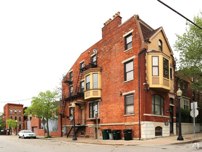
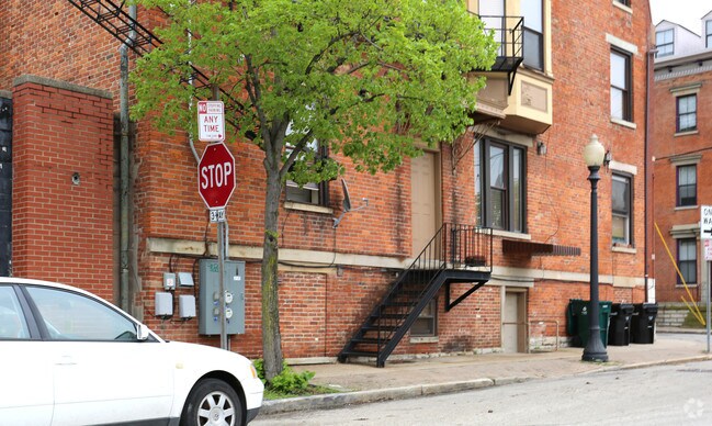
Property Record
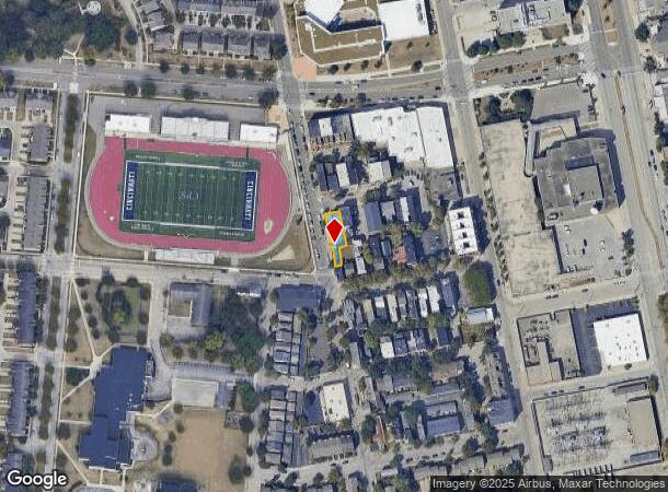
437 Hopkins St, Cincinnati, OH 45203
NEARBY LISTINGS FOR SALE OR LEASE
Property Detail
437 Hopkins St
134-0005-0063
Betts Sub
Multifamilydwelling
SE COR HOPKINS & JOHN ST 0.113 AC SQ 3 BETTS SUB PARS 63-66 CONS R1 T4 S18
X
Hamilton
21037C0007E
Ohio
2024
0.14 AC
2024
West End
026400
Cincinnati/Dayton
3,522 SF
Cincinnati, OH-KY-IN
DEMOGRAPHICS near 437 Hopkins St
1 Mile
3 Mile
5 Mile
2024 Total Population
24,885
158,869
336,284
2029 Population
25,573
162,166
340,283
Pop Growth 2024-2029
+ 2.76%
+ 2.08%
+ 1.19%
Average Age
36
36
37
2024 Total Households
13,181
71,749
147,419
HH Growth 2024-2029
+ 2.98%
+ 2.24%
+ 1.23%
Median Household Inc
$58,910
$44,926
$49,207
Avg Household Size
1.70
2.00
2.10
2024 Avg HH Vehicles
1.00
1.00
1.00
Median Home Value
$372,198
$215,400
$197,090
Median Year Built
1949
1948
1952
Nearby Places
Map Layers
Map Styles
 Street
 Aerial
- Restaurants
- Banks
- Shops
- Fitness
- Groceries
PUBLIC TRANSPORTATION
TRANSIT/SUBWAY
14Th & Elm Station (Streetcar - OTR - Banks - Southwest Ohio Regional Transit Authority)
DRIVE
WALK
Distance
14Th & Elm Station (Streetcar - OTR - Banks - Southwest Ohio Regional Transit Authority)
2 min
7 min
0.4 mi
Washington Park Station, 12Th & Race (Streetcar - OTR - Banks - Southwest Ohio Regional Transit Authority)
DRIVE
WALK
Distance
Washington Park Station, 12Th & Race (Streetcar - OTR - Banks - Southwest Ohio Regional Transit Authority)
2 min
8 min
0.4 mi
Central Parkway & Vine Station (Streetcar - OTR - Banks - Southwest Ohio Regional Transit Authority)
DRIVE
WALK
Distance
Central Parkway & Vine Station (Streetcar - OTR - Banks - Southwest Ohio Regional Transit Authority)
3 min
10 min
0.6 mi
Elm & Liberty Station (Streetcar - OTR - Banks - Southwest Ohio Regional Transit Authority)
DRIVE
WALK
Distance
Elm & Liberty Station (Streetcar - OTR - Banks - Southwest Ohio Regional Transit Authority)
2 min
11 min
0.6 mi
Race & Liberty Station (Streetcar - OTR - Banks - Southwest Ohio Regional Transit Authority)
DRIVE
WALK
Distance
Race & Liberty Station (Streetcar - OTR - Banks - Southwest Ohio Regional Transit Authority)
2 min
12 min
0.7 mi
COMMUTER RAIL
Cincinnati Union Terminal (Cardinal - Amtrak)
DRIVE
WALK
Distance
Cincinnati Union Terminal (Cardinal - Amtrak)
3 min
16 min
0.9 mi
AIRPORT
Cincinnati/Northern Kentucky International
DRIVE
WALK
Distance
Cincinnati/Northern Kentucky International
27 min
14.2 mi
Freight Ports
Port of Toledo
DRIVE
WALK
Distance
Port of Toledo
241 min
205.7 mi
Nearby Properties
Address
Land Use
TOTAL SIZE
Lot Size
Zoning
Address
Land Use
TOTAL SIZE
Lot Size
Zoning
77.73 AC
IR
Address
Land Use
TOTAL SIZE
Lot Size
Zoning
6.35 AC
IR
Address
Land Use
TOTAL SIZE
Lot Size
Zoning
39.99 AC
MG
Address
Land Use
TOTAL SIZE
Lot Size
Zoning
11.82 AC
Address
Land Use
TOTAL SIZE
Lot Size
Zoning
19.36 AC
Address
Land Use
TOTAL SIZE
Lot Size
Zoning
17.10 AC
DD
Address
Land Use
TOTAL SIZE
Lot Size
Zoning
1.97 AC
DD
Address
Land Use
TOTAL SIZE
Lot Size
Zoning
11.41 AC
IR
Address
Land Use
TOTAL SIZE
Lot Size
Zoning
22.45 AC
Address
Land Use
TOTAL SIZE
Lot Size
Zoning
60,750 SF
1.52 AC
Address
Land Use
TOTAL SIZE
Lot Size
Zoning
2.60 AC
Address
Land Use
TOTAL SIZE
Lot Size
Zoning
9.55 AC
Address
Land Use
TOTAL SIZE
Lot Size
Zoning
3.09 AC
Address
Land Use
TOTAL SIZE
Lot Size
Zoning
2.80 AC
IR
Address
Land Use
TOTAL SIZE
Lot Size
Zoning
3.40 AC
IR
Address
Land Use
TOTAL SIZE
Lot Size
Zoning
89,500 SF
0.58 AC
Address
Land Use
TOTAL SIZE
Lot Size
Zoning
Address
Land Use
TOTAL SIZE
Lot Size
Zoning
290,233 SF
Address
Land Use
TOTAL SIZE
Lot Size
Zoning
3.51 AC
DD
Address
Land Use
TOTAL SIZE
Lot Size
Zoning
9,962 SF
712 AC
Address
Land Use
TOTAL SIZE
Lot Size
Zoning
Address
Land Use
TOTAL SIZE
Lot Size
Zoning
153,312 SF
4 AC
Address
Land Use
TOTAL SIZE
Lot Size
Zoning
9.14 AC
Address
Land Use
TOTAL SIZE
Lot Size
Zoning
21.55 AC
Address
Land Use
TOTAL SIZE
Lot Size
Zoning
298,611 SF
Address
Land Use
TOTAL SIZE
Lot Size
Zoning
20.02 AC
Address
Land Use
TOTAL SIZE
Lot Size
Zoning
165,016 SF
15.23 AC
Address
Land Use
TOTAL SIZE
Lot Size
Zoning
7.14 AC
Address
Land Use
TOTAL SIZE
Lot Size
Zoning
256,000 SF
Address
Land Use
TOTAL SIZE
Lot Size
Zoning
1.95 AC
The World's #1 Commercial Real Estate Marketplace
Connect with us
© 2025 CoStar Group
The information above has been obtained from sources believed reliable. While we do not doubt its accuracy we have not verified it and make no guarantee, warranty or representation about it. It is your responsibility to independently confirm its accuracy and completeness. Any projections, opinions, assumptions, or estimates used are for example only and do not represent the current or future performance of the property. The value of this transaction to you depends on tax and other factors which should be evaluated by your tax, financial, and legal advisors. You and your advisors should conduct a careful, independent investigation of the property to determine to your satisfaction the suitability of the property for your needs.