Property Record
437 N 34Th St, Seattle, WA 98103
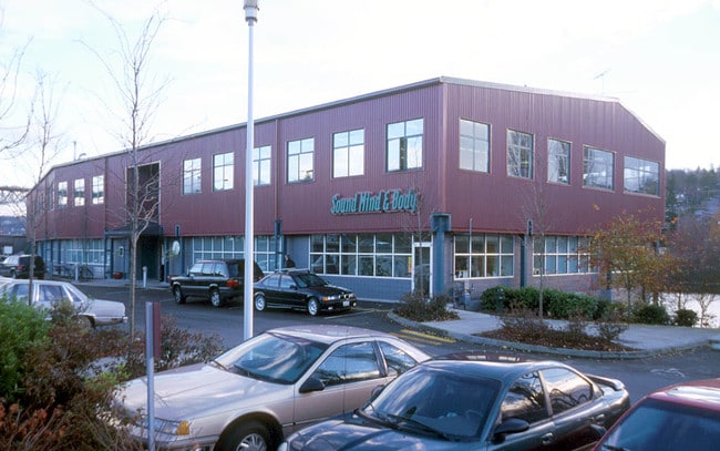

Property Detail
437 N 34Th St
197220-6512
DENNY & HOYTS ADD PORTIONS BLKS 71 & 72 DENNY & HOYTS ADDITION TO CITY OF SEATTLE & OF BURLINGTON NORTHERN INC'S FORMER SUMAS BRANCH R/W & OF VACATED N 33RD ST DAF: BEG AT CONCRETE MONUMENT WITH U.S. ARMY CORPS OF ENGINEERS BRASS DISC MARKING MOST NL
Officebuilding
King
IC-65 (M)
Washington
B and X Area of moderate flood hazard, usually the area between the limits of the 100-year and 500-year floods.
pors
2025
1.51 AC
2024
Greenwood/Fremont
004902
Seattle/Puget Sound
53,108 SF
Seattle-Tacoma-Bellevue, WA
NEARBY LISTINGS FOR SALE OR LEASE
DEMOGRAPHICS near 437 N 34Th St
1 mile
3 mile
5 mile
2025 Total Population
38,700
341,878
552,957
2030 Population
40,648
359,282
580,954
Pop Growth 2025-2030
+ 5.03%
+ 5.09%
+ 5.06%
Average Age
36
37
38
2025 Total Households
18,457
177,136
273,963
HH Growth 2025-2030
+ 5.05%
+ 5.44%
+ 5.39%
Median Household Inc
$135,617
$125,441
$125,738
Avg Household Size
1.90
1.80
1.90
2025 Avg HH Vehicles
1.00
1.00
1.00
Median Home Value
$1,067,370
$1,025,427
$1,018,623
Median Year Built
1977
1986
1981
Nearby Places
Map Layers
Map Styles
 Street
 Aerial
Layers
 Traffic
 Biking
Places
Listings with unknown addresses are not visible on the map
- Restaurants
- Banks
- Shops
- Fitness
- Groceries
PUBLIC TRANSPORTATION
COMMUTER RAIL
King Street (Seattle) Station (Sounder South Line - Central Puget Sound Regional Transit Authority Rail (Link Light Rail/Sounder))
Drive
Walk
Distance
King Street (Seattle) Station (Sounder South Line - Central Puget Sound Regional Transit Authority Rail (Link Light Rail/Sounder))
13 min
5.6 mi
AIRPORT
Seattle-Tacoma International
Drive
Walk
Distance
Seattle-Tacoma International
32 min
17.1 mi
Seattle Paine Field International
Drive
Walk
Distance
Seattle Paine Field International
37 min
22.0 mi
Nearby Properties
Address
Land Use
TOTAL SIZE
Lot Size
Zoning
Address
Land Use
TOTAL SIZE
Lot Size
Zoning
800,000 SF
8.57 AC
SM-UP 95 (
Address
Land Use
TOTAL SIZE
Lot Size
Zoning
471.20 AC
MIO-37-LR1
Address
Land Use
TOTAL SIZE
Lot Size
Zoning
2.84 AC
DMC 340/29
Address
Land Use
TOTAL SIZE
Lot Size
Zoning
946,212 SF
1.58 AC
DMC 340/29
Address
Land Use
TOTAL SIZE
Lot Size
Zoning
686,722 SF
1.26 AC
SM-SLU 240
Address
Land Use
TOTAL SIZE
Lot Size
Zoning
36,864 SF
8.02 AC
SM-UP 95 (
Address
Land Use
TOTAL SIZE
Lot Size
Zoning
716,128 SF
1.41 AC
SM-SLU 175
Address
Land Use
TOTAL SIZE
Lot Size
Zoning
1,062,251 SF
1.47 AC
DOC2 500/3
Address
Land Use
TOTAL SIZE
Lot Size
Zoning
763,898 SF
2.03 AC
DOC2 500/3
Address
Land Use
TOTAL SIZE
Lot Size
Zoning
1,137,666 SF
2.07 AC
DOC1 U/450
Address
Land Use
TOTAL SIZE
Lot Size
Zoning
615,000 SF
0.88 AC
DOC2 500/3
Address
Land Use
TOTAL SIZE
Lot Size
Zoning
565,110 SF
29.11 AC
II U/85
Address
Land Use
TOTAL SIZE
Lot Size
Zoning
377,813 SF
1.65 AC
DOC2 500/3
Address
Land Use
TOTAL SIZE
Lot Size
Zoning
67,235 SF
0.45 AC
DOC2 500/3
Address
Land Use
TOTAL SIZE
Lot Size
Zoning
922,344 SF
1.33 AC
DRC 85-170
Address
Land Use
TOTAL SIZE
Lot Size
Zoning
1,478,612 SF
0.80 AC
DOC2 500/3
Address
Land Use
TOTAL SIZE
Lot Size
Zoning
413,982 SF
0.58 AC
DMC 340/29
Address
Land Use
TOTAL SIZE
Lot Size
Zoning
943,610 SF
1.24 AC
DOC1 U/450
Address
Land Use
TOTAL SIZE
Lot Size
Zoning
155,795 SF
7.89 AC
SM-UP 95 (
Address
Land Use
TOTAL SIZE
Lot Size
Zoning
612,844 SF
0.09 AC
SM-U/R 75-
Address
Land Use
TOTAL SIZE
Lot Size
Zoning
411,654 SF
0.59 AC
DMC 240/29
Address
Land Use
TOTAL SIZE
Lot Size
Zoning
5,073 SF
25.99 AC
II U/85
Address
Land Use
TOTAL SIZE
Lot Size
Zoning
6,740 SF
46.38 AC
C2-55 (M)
Address
Land Use
TOTAL SIZE
Lot Size
Zoning
90,184 SF
16.66 AC
C1-75 (M)
Address
Land Use
TOTAL SIZE
Lot Size
Zoning
436,497 SF
1.64 AC
SM-SLU 175
Address
Land Use
TOTAL SIZE
Lot Size
Zoning
337,950 SF
0.44 AC
DMC 240/29
Address
Land Use
TOTAL SIZE
Lot Size
Zoning
957,631 SF
1.85 AC
SM-SLU 175
Address
Land Use
TOTAL SIZE
Lot Size
Zoning
339,296 SF
0.33 AC
SM-SLU 240
Address
Land Use
TOTAL SIZE
Lot Size
Zoning
997,378 SF
0.20 AC
DOC2 500/3
The World's #1 Commercial Real Estate Marketplace
Connect with us
© 2026 CoStar Group
The information above has been obtained from sources believed reliable. While we do not doubt its accuracy we have not verified it and make no guarantee, warranty or representation about it. It is your responsibility to independently confirm its accuracy and completeness. Any projections, opinions, assumptions, or estimates used are for example only and do not represent the current or future performance of the property. The value of this transaction to you depends on tax and other factors which should be evaluated by your tax, financial, and legal advisors. You and your advisors should conduct a careful, independent investigation of the property to determine to your satisfaction the suitability of the property for your needs.