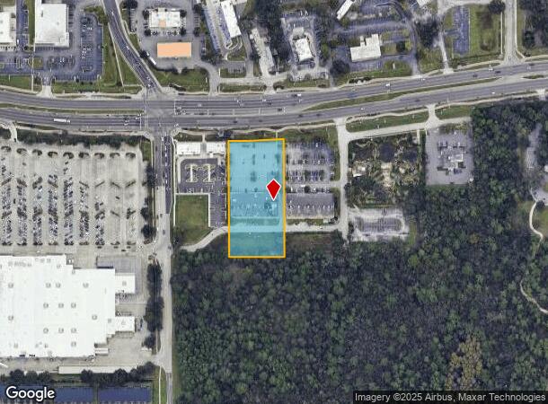
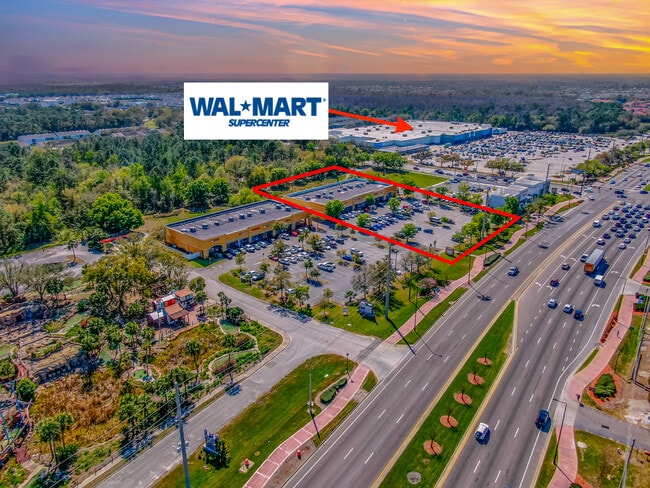
Property Record
4370 W Vine St, Kissimmee, FL 34746
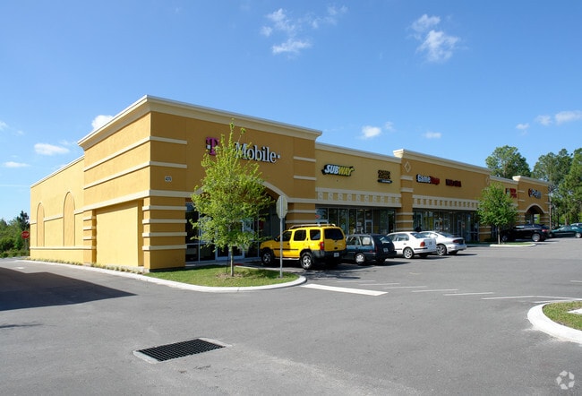
This Property Is For Sale
NEARBY LISTINGS FOR SALE OR LEASE
Property Detail
4370 W Vine St
Orlando-Kissimmee-Sanford, FL
Bass 192
19-25-29-1037-0001-0020
BASS 192 PB 18 PG 6 LOT 2
Storebuilding
Osceola
X
Florida
12097C0065G
2
2024
2.20 AC
2025
Kissimmee
040901
Orlando
16,835 SF
DEMOGRAPHICS near 4370 W Vine St
1 Mile
3 Mile
5 Mile
2024 Total Population
9,895
78,595
156,765
2029 Population
12,161
95,252
185,903
Pop Growth 2024-2029
+ 22.90%
+ 21.19%
+ 18.59%
Average Age
36
37
38
2024 Total Households
3,178
26,801
53,839
HH Growth 2024-2029
+ 22.59%
+ 20.97%
+ 18.39%
Median Household Inc
$53,702
$45,314
$52,594
Avg Household Size
3.10
2.90
2.80
2024 Avg HH Vehicles
2.00
2.00
2.00
Median Home Value
$296,219
$265,964
$274,975
Median Year Built
2003
1996
1998
Nearby Places
- Restaurants
- Banks
- Shops
- Fitness
- Groceries
PUBLIC TRANSPORTATION
COMMUTER RAIL
Kissimmee Amtrak Station (Silver Meteor - Amtrak, Silver Star - Amtrak, SunRail - Amtrak)
DRIVE
WALK
Distance
Kissimmee Amtrak Station (Silver Meteor - Amtrak, Silver Star - Amtrak, SunRail - Amtrak)
8 min
4.1 mi
Poinciana (SunRail - Florida Department of Transportation)
DRIVE
WALK
Distance
Poinciana (SunRail - Florida Department of Transportation)
9 min
5.1 mi
AIRPORT
Orlando International
DRIVE
WALK
Distance
Orlando International
30 min
19.8 mi
Freight Ports
Port Canaveral
DRIVE
WALK
Distance
Port Canaveral
76 min
61.5 mi
Nearby Properties
Address
Land Use
TOTAL SIZE
Lot Size
Zoning
Address
Land Use
TOTAL SIZE
Lot Size
Zoning
579,863 SF
25.98 AC
KHF
Address
Land Use
TOTAL SIZE
Lot Size
Zoning
387,298 SF
19.17 AC
KMPU
Address
Land Use
TOTAL SIZE
Lot Size
Zoning
426,324 SF
25.52 AC
KRC2
Address
Land Use
TOTAL SIZE
Lot Size
Zoning
405,322 SF
27.68 AC
OCT
Address
Land Use
TOTAL SIZE
Lot Size
Zoning
360,431 SF
34.06 AC
KRPU
Address
Land Use
TOTAL SIZE
Lot Size
Zoning
449,570 SF
15.34 AC
OPD
Address
Land Use
TOTAL SIZE
Lot Size
Zoning
305,166 SF
30.36 AC
KMPU
Address
Land Use
TOTAL SIZE
Lot Size
Zoning
348,817 SF
12.83 AC
OPUD
Address
Land Use
TOTAL SIZE
Lot Size
Zoning
330,113 SF
21.83 AC
KSRP
Address
Land Use
TOTAL SIZE
Lot Size
Zoning
286,320 SF
27.06 AC
Address
Land Use
TOTAL SIZE
Lot Size
Zoning
469,677 SF
69.98 AC
KSRP
Address
Land Use
TOTAL SIZE
Lot Size
Zoning
298,788 SF
12.07 AC
KAE
Address
Land Use
TOTAL SIZE
Lot Size
Zoning
331,236 SF
21.86 AC
KMPU
Address
Land Use
TOTAL SIZE
Lot Size
Zoning
366,024 SF
19.19 AC
KRC1
Address
Land Use
TOTAL SIZE
Lot Size
Zoning
239,567 SF
14.39 AC
OPUD
Address
Land Use
TOTAL SIZE
Lot Size
Zoning
325,244 SF
33.13 AC
KMPU
Address
Land Use
TOTAL SIZE
Lot Size
Zoning
172,394 SF
17.95 AC
KRC1
Address
Land Use
TOTAL SIZE
Lot Size
Zoning
232,770 SF
11.91 AC
KRC2
Address
Land Use
TOTAL SIZE
Lot Size
Zoning
230,530 SF
17.74 AC
KRPU
Address
Land Use
TOTAL SIZE
Lot Size
Zoning
219,362 SF
15.64 AC
KRC1
Address
Land Use
TOTAL SIZE
Lot Size
Zoning
467,489 SF
34.04 AC
KHC
Address
Land Use
TOTAL SIZE
Lot Size
Zoning
415,217 SF
29.06 AC
KRC1
Address
Land Use
TOTAL SIZE
Lot Size
Zoning
170,602 SF
17.07 AC
KRC1
Address
Land Use
TOTAL SIZE
Lot Size
Zoning
374,703 SF
8.05 AC
OPD
Address
Land Use
TOTAL SIZE
Lot Size
Zoning
59,237 SF
0.54 AC
LAR3
Address
Land Use
TOTAL SIZE
Lot Size
Zoning
177,376 SF
8.62 AC
KRC1
Address
Land Use
TOTAL SIZE
Lot Size
Zoning
180,209 SF
16 AC
KRC1
Address
Land Use
TOTAL SIZE
Lot Size
Zoning
449,487 SF
4.64 AC
KCF
Address
Land Use
TOTAL SIZE
Lot Size
Zoning
116,831 SF
14.17 AC
KMPU
Address
Land Use
TOTAL SIZE
Lot Size
Zoning
188,009 SF
10.28 AC
KMPU
The World's #1 Commercial Real Estate Marketplace
Connect with us
© 2025 CoStar Group
The information above has been obtained from sources believed reliable. While we do not doubt its accuracy we have not verified it and make no guarantee, warranty or representation about it. It is your responsibility to independently confirm its accuracy and completeness. Any projections, opinions, assumptions, or estimates used are for example only and do not represent the current or future performance of the property. The value of this transaction to you depends on tax and other factors which should be evaluated by your tax, financial, and legal advisors. You and your advisors should conduct a careful, independent investigation of the property to determine to your satisfaction the suitability of the property for your needs.