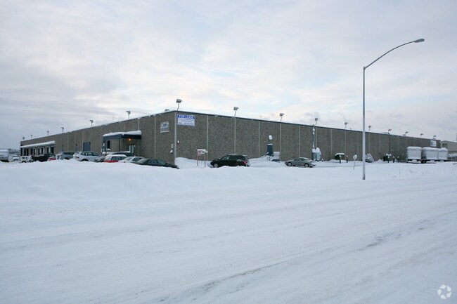
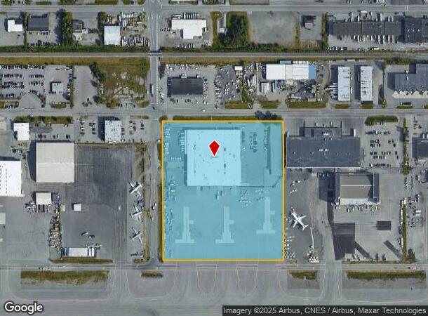
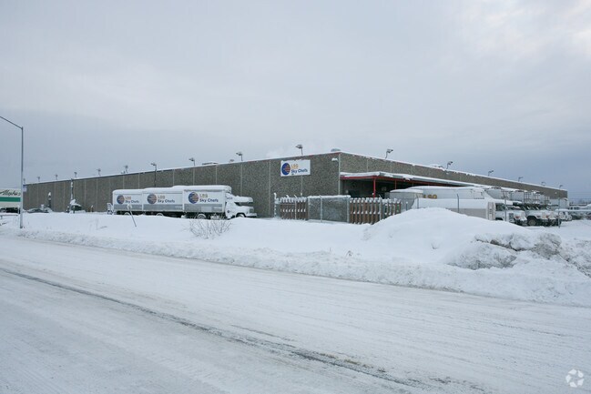
Property Record
4370 Old International Airport Rd, Anchorage, AK 99502
NEARBY LISTINGS FOR SALE OR LEASE
-
-
View all Anchorage listings for sale on LoopNet.com
Property Detail
4370 Old International Airport Rd
Anchorage, AK
Intl Arpt
01038124001
ADA 0988 INTL ARPT BLK 3 LT 5B
Warehouse
Anchorage
X
Alaska
0200050740D
5b
2024
5.93 AC
2025
W Tudor/Dimond-15
002304
Anchorage
91,395 SF
DEMOGRAPHICS near 4370 Old International Airport Rd
1 Mile
3 Mile
5 Mile
2024 Total Population
2,497
55,462
121,160
2029 Population
2,482
54,689
119,447
Pop Growth 2024-2029
(0.60%)
(1.39%)
(1.41%)
Average Age
39
39
38
2024 Total Households
985
22,575
48,929
HH Growth 2024-2029
(0.71%)
(1.44%)
(1.44%)
Median Household Inc
$122,944
$90,141
$86,062
Avg Household Size
2.50
2.40
2.30
2024 Avg HH Vehicles
2.00
2.00
2.00
Median Home Value
$393,352
$354,429
$339,390
Median Year Built
1985
1978
1979
Nearby Places
Map Layers
Map Styles
 Street
 Aerial
- Restaurants
- Banks
- Shops
- Fitness
- Groceries
PUBLIC TRANSPORTATION
AIRPORT
Ted Stevens Anchorage International
DRIVE
WALK
Distance
Ted Stevens Anchorage International
4 min
1.1 mi
Merrill Field
DRIVE
WALK
Distance
Merrill Field
16 min
7.8 mi
Freight Ports
Port of Anchorage
DRIVE
WALK
Distance
Port of Anchorage
17 min
7.9 mi
Nearby Properties
Address
Land Use
TOTAL SIZE
Lot Size
Zoning
Address
Land Use
TOTAL SIZE
Lot Size
Zoning
91,034 SF
63.70 AC
TR
Address
Land Use
TOTAL SIZE
Lot Size
Zoning
117,702 SF
9.85 AC
B3SL
Address
Land Use
TOTAL SIZE
Lot Size
Zoning
195,079 SF
44.79 AC
PLI
Address
Land Use
TOTAL SIZE
Lot Size
Zoning
267,442 SF
61.04 AC
PLI
Address
Land Use
TOTAL SIZE
Lot Size
Zoning
61,127 SF
3.04 AC
B3
Address
Land Use
TOTAL SIZE
Lot Size
Zoning
191.79 AC
PLI
Address
Land Use
TOTAL SIZE
Lot Size
Zoning
65,314 SF
111.15 AC
PLI
Address
Land Use
TOTAL SIZE
Lot Size
Zoning
121,359 SF
4.35 AC
B3SL
Address
Land Use
TOTAL SIZE
Lot Size
Zoning
56,747 SF
6.89 AC
B3SL
Address
Land Use
TOTAL SIZE
Lot Size
Zoning
66,354 SF
44.23 AC
I2
Address
Land Use
TOTAL SIZE
Lot Size
Zoning
134.97 AC
TR
Address
Land Use
TOTAL SIZE
Lot Size
Zoning
242,189 SF
21.83 AC
I2
Address
Land Use
TOTAL SIZE
Lot Size
Zoning
168,640 SF
3.38 AC
I2
Address
Land Use
TOTAL SIZE
Lot Size
Zoning
341,267 SF
5.51 AC
TR
Address
Land Use
TOTAL SIZE
Lot Size
Zoning
217,754 SF
14.42 AC
I1
Address
Land Use
TOTAL SIZE
Lot Size
Zoning
79.26 AC
PLI
Address
Land Use
TOTAL SIZE
Lot Size
Zoning
103,442 SF
3.50 AC
B3
Address
Land Use
TOTAL SIZE
Lot Size
Zoning
36,178 SF
2.19 AC
I1
Address
Land Use
TOTAL SIZE
Lot Size
Zoning
59,908 SF
5.54 AC
I1
Address
Land Use
TOTAL SIZE
Lot Size
Zoning
1,944 SF
3.18 AC
B3
Address
Land Use
TOTAL SIZE
Lot Size
Zoning
3,813 SF
31.29 AC
PLIP
Address
Land Use
TOTAL SIZE
Lot Size
Zoning
97,524 SF
6.85 AC
TR
Address
Land Use
TOTAL SIZE
Lot Size
Zoning
61,674 SF
5 AC
B3SL
Address
Land Use
TOTAL SIZE
Lot Size
Zoning
32,247 SF
2.21 AC
B3
Address
Land Use
TOTAL SIZE
Lot Size
Zoning
30,016 SF
3.74 AC
B3
Address
Land Use
TOTAL SIZE
Lot Size
Zoning
48,770 SF
2.90 AC
I1
Address
Land Use
TOTAL SIZE
Lot Size
Zoning
75,412 SF
3.32 AC
B3
Address
Land Use
TOTAL SIZE
Lot Size
Zoning
65,752 SF
1.82 AC
I1
Address
Land Use
TOTAL SIZE
Lot Size
Zoning
49,032 SF
3.07 AC
B3
Address
Land Use
TOTAL SIZE
Lot Size
Zoning
45,105 SF
10.96 AC
B3
The World's #1 Commercial Real Estate Marketplace
Connect with us
© 2025 CoStar Group
The information above has been obtained from sources believed reliable. While we do not doubt its accuracy we have not verified it and make no guarantee, warranty or representation about it. It is your responsibility to independently confirm its accuracy and completeness. Any projections, opinions, assumptions, or estimates used are for example only and do not represent the current or future performance of the property. The value of this transaction to you depends on tax and other factors which should be evaluated by your tax, financial, and legal advisors. You and your advisors should conduct a careful, independent investigation of the property to determine to your satisfaction the suitability of the property for your needs.