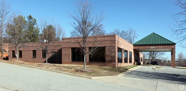
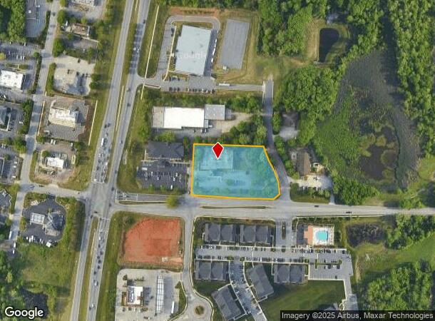
Property Record
4370 Regency Dr, High Point, NC 27265

NEARBY LISTINGS FOR SALE OR LEASE
Property Detail
4370 Regency Dr
Greensboro-High Point, NC
Piedmont Centre
0207798
3 PB130-113 PIEDMONT CTRE PL:130-113
Officebuilding
Guilford
X
North Carolina
3710781400J
3
0
1.90 AC
2025
Airport/W Guilford County
016406
Greensboro/Winston-Salem
12,572 SF
DEMOGRAPHICS near 4370 Regency Dr
1 Mile
3 Mile
5 Mile
2024 Total Population
763
30,994
97,507
2029 Population
768
31,047
97,337
Pop Growth 2024-2029
+ 0.66%
+ 0.17%
(0.17%)
Average Age
37
40
41
2024 Total Households
354
13,163
42,902
HH Growth 2024-2029
+ 0.56%
+ 0.08%
(0.21%)
Median Household Inc
$84,429
$77,181
$69,362
Avg Household Size
2.10
2.30
2.20
2024 Avg HH Vehicles
2.00
2.00
2.00
Median Home Value
$228,947
$249,414
$228,090
Median Year Built
2005
1999
1994
Nearby Places
Map Layers
Map Styles
 Street
 Aerial
- Restaurants
- Banks
- Shops
- Fitness
- Groceries
PUBLIC TRANSPORTATION
COMMUTER RAIL
High Point Station (Piedmont - North Carolina by Train (NC Train))
DRIVE
WALK
Distance
High Point Station (Piedmont - North Carolina by Train (NC Train))
14 min
8.2 mi
AIRPORT
Piedmont Triad International
DRIVE
WALK
Distance
Piedmont Triad International
13 min
7.7 mi
Nearby Properties
Address
Land Use
TOTAL SIZE
Lot Size
Zoning
Address
Land Use
TOTAL SIZE
Lot Size
Zoning
37,237 SF
334.45 AC
HI
Address
Land Use
TOTAL SIZE
Lot Size
Zoning
1,057,283 SF
104.31 AC
PDP
Address
Land Use
TOTAL SIZE
Lot Size
Zoning
256,051 SF
37.69 AC
LI
Address
Land Use
TOTAL SIZE
Lot Size
Zoning
905,735 SF
39.66 AC
AR
Address
Land Use
TOTAL SIZE
Lot Size
Zoning
410,298 SF
33.10 AC
RM-12
Address
Land Use
TOTAL SIZE
Lot Size
Zoning
691,408 SF
58.69 AC
LI
Address
Land Use
TOTAL SIZE
Lot Size
Zoning
186,200 SF
10.58 AC
LI
Address
Land Use
TOTAL SIZE
Lot Size
Zoning
552,314 SF
38.47 AC
PDR
Address
Land Use
TOTAL SIZE
Lot Size
Zoning
230,664 SF
13.69 AC
HI
Address
Land Use
TOTAL SIZE
Lot Size
Zoning
374,522 SF
56.55 AC
HI
Address
Land Use
TOTAL SIZE
Lot Size
Zoning
509,216 SF
40.85 AC
LI
Address
Land Use
TOTAL SIZE
Lot Size
Zoning
400,000 SF
46.72 AC
LI
Address
Land Use
TOTAL SIZE
Lot Size
Zoning
354,454 SF
20.65 AC
RM-18
Address
Land Use
TOTAL SIZE
Lot Size
Zoning
229,103 SF
18.76 AC
CZ-I
Address
Land Use
TOTAL SIZE
Lot Size
Zoning
683,263 SF
52.92 AC
HI
Address
Land Use
TOTAL SIZE
Lot Size
Zoning
291,895 SF
21.52 AC
RM-26
Address
Land Use
TOTAL SIZE
Lot Size
Zoning
363,308 SF
29.41 AC
RM-16
Address
Land Use
TOTAL SIZE
Lot Size
Zoning
145,105 SF
20.12 AC
C-M
Address
Land Use
TOTAL SIZE
Lot Size
Zoning
309,749 SF
16.74 AC
CZ-PDM
Address
Land Use
TOTAL SIZE
Lot Size
Zoning
362,708 SF
56.81 AC
LI
Address
Land Use
TOTAL SIZE
Lot Size
Zoning
53,362 SF
0.51 AC
LAR3
Address
Land Use
TOTAL SIZE
Lot Size
Zoning
274,999 SF
21.57 AC
LI
Address
Land Use
TOTAL SIZE
Lot Size
Zoning
325.42 AC
HI
Address
Land Use
TOTAL SIZE
Lot Size
Zoning
214,941 SF
13.29 AC
PDR
Address
Land Use
TOTAL SIZE
Lot Size
Zoning
299,786 SF
24.49 AC
PDP
Address
Land Use
TOTAL SIZE
Lot Size
Zoning
293,851 SF
36.66 AC
PUD
Address
Land Use
TOTAL SIZE
Lot Size
Zoning
251,598 SF
9.60 AC
PUD
Address
Land Use
TOTAL SIZE
Lot Size
Zoning
227,652 SF
21.64 AC
LI
Address
Land Use
TOTAL SIZE
Lot Size
Zoning
240,936 SF
12.02 AC
PDM
Address
Land Use
TOTAL SIZE
Lot Size
Zoning
269,956 SF
19.44 AC
OI
The World's #1 Commercial Real Estate Marketplace
Connect with us
© 2026 CoStar Group
The information above has been obtained from sources believed reliable. While we do not doubt its accuracy we have not verified it and make no guarantee, warranty or representation about it. It is your responsibility to independently confirm its accuracy and completeness. Any projections, opinions, assumptions, or estimates used are for example only and do not represent the current or future performance of the property. The value of this transaction to you depends on tax and other factors which should be evaluated by your tax, financial, and legal advisors. You and your advisors should conduct a careful, independent investigation of the property to determine to your satisfaction the suitability of the property for your needs.