Property Record
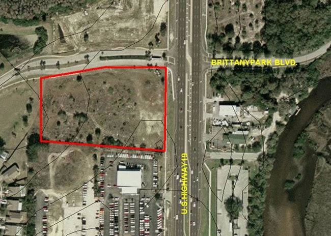
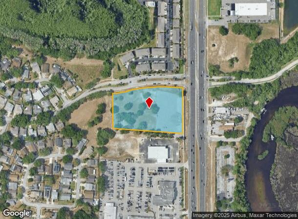
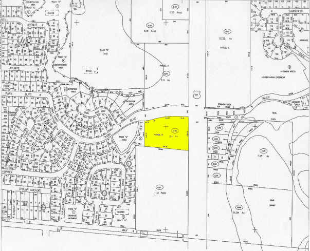
43700 Us Highway 19 N, Tarpon Springs, FL 34689
NEARBY LISTINGS FOR SALE OR LEASE
Property Detail
43700 Us Highway 19 N
Tampa-St. Petersburg-Clearwater, FL
Part Of N 1/2 Of Sec
06-27-16-00000-210-0500
PART OF N 1/2 OF SEC 6-27-16 DESC FROM NW COR OF NE 1/4 OF SD SEC TH S89D5813E 82.46FT ALG N SEC LINE TO W R/W OF US HWY 19 TH S00D0526W 1161.10FT FOR POB TH S00D0526W 326.04FT TH N85D2336W 501.56FT TH N00D0526E 246.72FT TH CUR LT RAD 410FT CB N83D43
Commercialacreage
Pinellas
X
Florida
12103C0036H
25
2024
3.39 AC
2025
North Pinellas
027503
Tampa/St Petersburg
DEMOGRAPHICS near 43700 Us Highway 19 N
1 Mile
3 Mile
5 Mile
2024 Total Population
8,571
69,936
148,675
2029 Population
9,708
80,071
169,423
Pop Growth 2024-2029
+ 13.27%
+ 14.49%
+ 13.96%
Average Age
43
45
45
2024 Total Households
3,661
30,280
64,100
HH Growth 2024-2029
+ 14.26%
+ 14.42%
+ 13.83%
Median Household Inc
$44,342
$45,572
$51,904
Avg Household Size
2.30
2.20
2.30
2024 Avg HH Vehicles
2.00
2.00
2.00
Median Home Value
$131,593
$179,874
$229,058
Median Year Built
1977
1977
1980
Nearby Places
Map Layers
Map Styles
 Street
 Aerial
- Restaurants
- Banks
- Shops
- Fitness
- Groceries
PUBLIC TRANSPORTATION
AIRPORT
Tampa International
DRIVE
WALK
Distance
Tampa International
40 min
24.1 mi
St Pete-Clearwater International
DRIVE
WALK
Distance
St Pete-Clearwater International
40 min
24.3 mi
Freight Ports
Port of Tampa Bay
DRIVE
WALK
Distance
Port of Tampa Bay
54 min
32.6 mi
Nearby Properties
Address
Land Use
TOTAL SIZE
Lot Size
Zoning
Address
Land Use
TOTAL SIZE
Lot Size
Zoning
341,775 SF
43.99 AC
Address
Land Use
TOTAL SIZE
Lot Size
Zoning
214,040 SF
8.47 AC
Address
Land Use
TOTAL SIZE
Lot Size
Zoning
286,598 SF
6.56 AC
Address
Land Use
TOTAL SIZE
Lot Size
Zoning
202,954 SF
49.22 AC
AR
Address
Land Use
TOTAL SIZE
Lot Size
Zoning
333,044 SF
25.64 AC
R4
Address
Land Use
TOTAL SIZE
Lot Size
Zoning
154,033 SF
15.86 AC
Address
Land Use
TOTAL SIZE
Lot Size
Zoning
157,476 SF
27.47 AC
MPUD
Address
Land Use
TOTAL SIZE
Lot Size
Zoning
264.64 AC
AC
Address
Land Use
TOTAL SIZE
Lot Size
Zoning
151,825 SF
18.01 AC
Address
Land Use
TOTAL SIZE
Lot Size
Zoning
4,955 SF
135.03 AC
Address
Land Use
TOTAL SIZE
Lot Size
Zoning
145,216 SF
7.58 AC
MF3
Address
Land Use
TOTAL SIZE
Lot Size
Zoning
131,819 SF
11.24 AC
Address
Land Use
TOTAL SIZE
Lot Size
Zoning
81,053 SF
9.52 AC
Address
Land Use
TOTAL SIZE
Lot Size
Zoning
121,869 SF
4.72 AC
C2
Address
Land Use
TOTAL SIZE
Lot Size
Zoning
43,469 SF
11.48 AC
MPUD
Address
Land Use
TOTAL SIZE
Lot Size
Zoning
141,763 SF
12.96 AC
Address
Land Use
TOTAL SIZE
Lot Size
Zoning
81,045 SF
16.34 AC
PUD
Address
Land Use
TOTAL SIZE
Lot Size
Zoning
77,900 SF
10.52 AC
C2
Address
Land Use
TOTAL SIZE
Lot Size
Zoning
67,179 SF
9.52 AC
Address
Land Use
TOTAL SIZE
Lot Size
Zoning
80,212 SF
6.64 AC
Address
Land Use
TOTAL SIZE
Lot Size
Zoning
86,556 SF
7.44 AC
R6
Address
Land Use
TOTAL SIZE
Lot Size
Zoning
77,716 SF
2.54 AC
Address
Land Use
TOTAL SIZE
Lot Size
Zoning
203,135 SF
41.04 AC
C2
Address
Land Use
TOTAL SIZE
Lot Size
Zoning
143,430 SF
8.68 AC
Address
Land Use
TOTAL SIZE
Lot Size
Zoning
74,641 SF
9.20 AC
C2
Address
Land Use
TOTAL SIZE
Lot Size
Zoning
87,794 SF
7.97 AC
Address
Land Use
TOTAL SIZE
Lot Size
Zoning
70,901 SF
5.70 AC
Address
Land Use
TOTAL SIZE
Lot Size
Zoning
45,674 SF
4.21 AC
Address
Land Use
TOTAL SIZE
Lot Size
Zoning
44,321 SF
9.65 AC
Address
Land Use
TOTAL SIZE
Lot Size
Zoning
59,196 SF
4.41 AC
The World's #1 Commercial Real Estate Marketplace
Connect with us
© 2025 CoStar Group
The information above has been obtained from sources believed reliable. While we do not doubt its accuracy we have not verified it and make no guarantee, warranty or representation about it. It is your responsibility to independently confirm its accuracy and completeness. Any projections, opinions, assumptions, or estimates used are for example only and do not represent the current or future performance of the property. The value of this transaction to you depends on tax and other factors which should be evaluated by your tax, financial, and legal advisors. You and your advisors should conduct a careful, independent investigation of the property to determine to your satisfaction the suitability of the property for your needs.