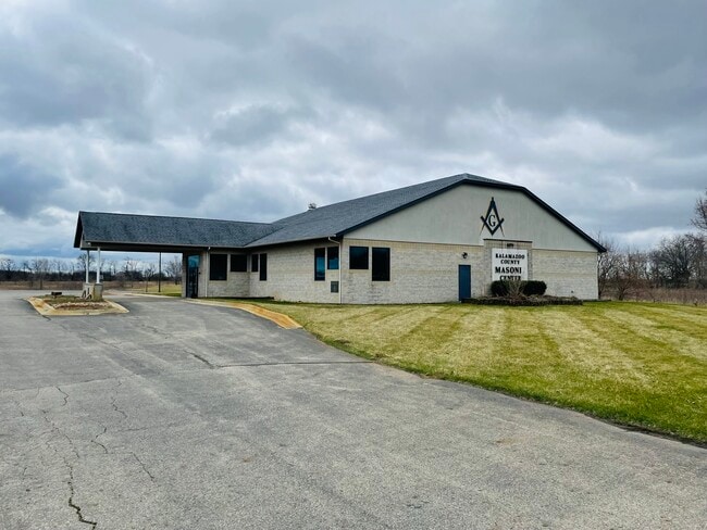
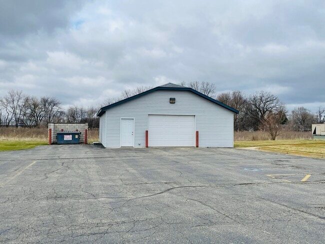
Property Record
4371 W U Ave, Schoolcraft, MI 49087

Property Detail
4371 W U Ave
14-07-130-015
SEC 7-4-11 BEG ON N SEC LI 712 FT W OF N 1/4 POST TH S 00 DEG 34 MIN 20 SEC E 580.80 FT TH E PAR WI N SEC LI 150 FT TH S 00
Commercialnec
Kalamazoo
B and X Area of moderate flood hazard, usually the area between the limits of the 100-year and 500-year floods.
Michigan
2024
4.03 AC
2025
Southern Kalamazoo County
006102
West Michigan
6,247 SF
Kalamazoo-Portage, MI
NEARBY LISTINGS FOR SALE OR LEASE
DEMOGRAPHICS near 4371 W U Ave
1 mile
3 mile
5 mile
2025 Total Population
365
5,955
32,319
2030 Population
362
5,937
32,272
Pop Growth 2025-2030
(0.82%)
(0.30%)
(0.15%)
Average Age
43
42
41
2025 Total Households
142
2,352
12,656
HH Growth 2025-2030
(1.41%)
(0.55%)
(0.28%)
Median Household Inc
$74,999
$94,292
$94,815
Avg Household Size
2.60
2.50
2.50
2025 Avg HH Vehicles
2.00
2.00
2.00
Median Home Value
$310,000
$283,928
$326,775
Median Year Built
1985
1978
1982
Nearby Places
Map Layers
Map Styles
 Street
 Aerial
Layers
 Traffic
 Biking
Places
Listings with unknown addresses are not visible on the map
- Restaurants
- Banks
- Shops
- Fitness
- Groceries
PUBLIC TRANSPORTATION
AIRPORT
Kalamazoo/Battle Creek International
Drive
Walk
Distance
Kalamazoo/Battle Creek International
20 min
12.3 mi
SALE & LEASE HISTORY
LISTING DATE
SALE/LEASE

May 16, 2022
For Sale
Nearby Properties
Address
Land Use
TOTAL SIZE
Lot Size
Zoning
Address
Land Use
TOTAL SIZE
Lot Size
Zoning
9,246 SF
10.24 AC
RM-1
Address
Land Use
TOTAL SIZE
Lot Size
Zoning
Address
Land Use
TOTAL SIZE
Lot Size
Zoning
22,809 SF
6.80 AC
RM-1
Address
Land Use
TOTAL SIZE
Lot Size
Zoning
19,497 SF
6.38 AC
SCHTWP.ORG
Address
Land Use
TOTAL SIZE
Lot Size
Zoning
137,342 SF
20.98 AC
Address
Land Use
TOTAL SIZE
Lot Size
Zoning
10.93 AC
Address
Land Use
TOTAL SIZE
Lot Size
Zoning
2,062 SF
142.41 AC
AG
Address
Land Use
TOTAL SIZE
Lot Size
Zoning
6.10 AC
Address
Land Use
TOTAL SIZE
Lot Size
Zoning
508.25 AC
R-1C
Address
Land Use
TOTAL SIZE
Lot Size
Zoning
62,520 SF
5.95 AC
Address
Land Use
TOTAL SIZE
Lot Size
Zoning
7,972 SF
26.05 AC
AG
Address
Land Use
TOTAL SIZE
Lot Size
Zoning
40.81 AC
Address
Land Use
TOTAL SIZE
Lot Size
Zoning
433.65 AC
R-1C
Address
Land Use
TOTAL SIZE
Lot Size
Zoning
2,150 SF
135.77 AC
AG
Address
Land Use
TOTAL SIZE
Lot Size
Zoning
4.80 AC
Address
Land Use
TOTAL SIZE
Lot Size
Zoning
2,097 SF
141.25 AC
AG
Address
Land Use
TOTAL SIZE
Lot Size
Zoning
49,196 SF
4.02 AC
Address
Land Use
TOTAL SIZE
Lot Size
Zoning
3.40 AC
I-1
Address
Land Use
TOTAL SIZE
Lot Size
Zoning
Address
Land Use
TOTAL SIZE
Lot Size
Zoning
5,760 SF
2.36 AC
Address
Land Use
TOTAL SIZE
Lot Size
Zoning
1,872 SF
160.88 AC
AG
Address
Land Use
TOTAL SIZE
Lot Size
Zoning
205.43 AC
AG
Address
Land Use
TOTAL SIZE
Lot Size
Zoning
2,768 SF
156.20 AC
AG
Address
Land Use
TOTAL SIZE
Lot Size
Zoning
19,528 SF
4.68 AC
Address
Land Use
TOTAL SIZE
Lot Size
Zoning
2,222 SF
101.66 AC
AG
Address
Land Use
TOTAL SIZE
Lot Size
Zoning
6,144 SF
1 AC
Address
Land Use
TOTAL SIZE
Lot Size
Zoning
2.43 AC
I-1
Address
Land Use
TOTAL SIZE
Lot Size
Zoning
5.41 AC
PH679-4304
Address
Land Use
TOTAL SIZE
Lot Size
Zoning
19,642 SF
10.08 AC
The World's #1 Commercial Real Estate Marketplace
Connect with us
© 2026 CoStar Group
The information above has been obtained from sources believed reliable. While we do not doubt its accuracy we have not verified it and make no guarantee, warranty or representation about it. It is your responsibility to independently confirm its accuracy and completeness. Any projections, opinions, assumptions, or estimates used are for example only and do not represent the current or future performance of the property. The value of this transaction to you depends on tax and other factors which should be evaluated by your tax, financial, and legal advisors. You and your advisors should conduct a careful, independent investigation of the property to determine to your satisfaction the suitability of the property for your needs.