Property Record
4372 Stone Mountain Hwy, Lilburn, GA 30047
NEARBY LISTINGS FOR SALE OR LEASE
-
-
View all Lilburn listings for sale on LoopNet.com
Property Detail
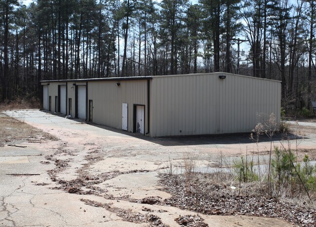
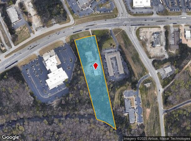
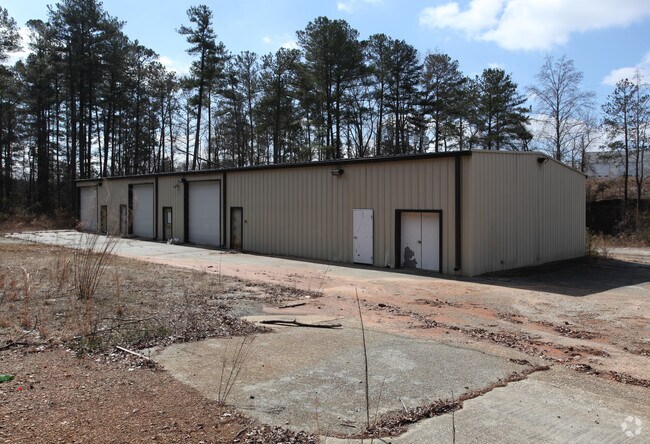
4372 Stone Mountain Hwy
6-055-124
U S Hwy 78
Warehouse
U S HWY 78
AE
Gwinnett
13089C0105K
Georgia
2025
4.07 AC
2025
Stone Mountain
050750
Atlanta
4,800 SF
Atlanta-Sandy Springs-Roswell, GA
DEMOGRAPHICS near 4372 Stone Mountain Hwy
1 mile
3 mile
5 mile
2024 Total Population
5,821
63,131
157,099
2029 Population
6,034
65,510
162,607
Pop Growth 2024-2029
+ 3.66%
+ 3.77%
+ 3.51%
Average Age
38
39
39
2024 Total Households
2,044
20,824
51,648
HH Growth 2024-2029
+ 3.77%
+ 3.79%
+ 3.49%
Median Household Inc
$84,689
$85,961
$86,569
Avg Household Size
2.80
3.00
3.00
2024 Avg HH Vehicles
2.00
2.00
2.00
Median Home Value
$273,409
$284,955
$289,017
Median Year Built
1985
1985
1986
Nearby Places
Map Layers
Map Styles
 Street
 Aerial
Transit
 Traffic
 Biking
Places
Listings with unknown addresses are not visible on the map
- Restaurants
- Banks
- Shops
- Fitness
- Groceries
PUBLIC TRANSPORTATION
AIRPORT
Hartsfield - Jackson Atlanta International
Drive
Walk
Distance
Hartsfield - Jackson Atlanta International
45 min
29.6 mi
Nearby Properties
Address
Land Use
TOTAL SIZE
Lot Size
Zoning
Address
Land Use
TOTAL SIZE
Lot Size
Zoning
Address
Land Use
TOTAL SIZE
Lot Size
Zoning
2,682,168 SF
80.24 AC
M1
Address
Land Use
TOTAL SIZE
Lot Size
Zoning
301,646 SF
23.90 AC
RM13
Address
Land Use
TOTAL SIZE
Lot Size
Zoning
462,669 SF
102.65 AC
R100
Address
Land Use
TOTAL SIZE
Lot Size
Zoning
232,617 SF
19.61 AC
RM
Address
Land Use
TOTAL SIZE
Lot Size
Zoning
307,313 SF
15.60 AC
RM24
Address
Land Use
TOTAL SIZE
Lot Size
Zoning
388,696 SF
13.89 AC
RM100
Address
Land Use
TOTAL SIZE
Lot Size
Zoning
339,612 SF
38.64 AC
C2
Address
Land Use
TOTAL SIZE
Lot Size
Zoning
526,306 SF
77.45 AC
R100
Address
Land Use
TOTAL SIZE
Lot Size
Zoning
278,756 SF
27.72 AC
RM
Address
Land Use
TOTAL SIZE
Lot Size
Zoning
3,500 SF
391.26 AC
R100
Address
Land Use
TOTAL SIZE
Lot Size
Zoning
335,605 SF
20.22 AC
RM100
Address
Land Use
TOTAL SIZE
Lot Size
Zoning
175,045 SF
13.01 AC
RM
Address
Land Use
TOTAL SIZE
Lot Size
Zoning
113,100 SF
11.39 AC
C2
Address
Land Use
TOTAL SIZE
Lot Size
Zoning
179,784 SF
6.57 AC
C2
Address
Land Use
TOTAL SIZE
Lot Size
Zoning
492 SF
208.14 AC
R100
Address
Land Use
TOTAL SIZE
Lot Size
Zoning
208,590 SF
26.01 AC
C2
Address
Land Use
TOTAL SIZE
Lot Size
Zoning
111,729 SF
6.67 AC
C2
Address
Land Use
TOTAL SIZE
Lot Size
Zoning
80,014 SF
9.73 AC
R100
Address
Land Use
TOTAL SIZE
Lot Size
Zoning
139,448 SF
15.97 AC
RM
Address
Land Use
TOTAL SIZE
Lot Size
Zoning
217,730 SF
29.68 AC
C2
Address
Land Use
TOTAL SIZE
Lot Size
Zoning
99,280 SF
4.51 AC
C2
Address
Land Use
TOTAL SIZE
Lot Size
Zoning
106,114 SF
16.59 AC
C2
Address
Land Use
TOTAL SIZE
Lot Size
Zoning
89,686 SF
18.29 AC
C2
Address
Land Use
TOTAL SIZE
Lot Size
Zoning
135,406 SF
14.10 AC
C2
Address
Land Use
TOTAL SIZE
Lot Size
Zoning
103,821 SF
10.80 AC
M1
Address
Land Use
TOTAL SIZE
Lot Size
Zoning
48,985 SF
17.87 AC
C2
Address
Land Use
TOTAL SIZE
Lot Size
Zoning
123,980 SF
11.50 AC
M1
Address
Land Use
TOTAL SIZE
Lot Size
Zoning
57,322 SF
9.18 AC
C2
Address
Land Use
TOTAL SIZE
Lot Size
Zoning
88,892 SF
7.50 AC
M1
The World's #1 Commercial Real Estate Marketplace
Connect with us
© 2026 CoStar Group
The information above has been obtained from sources believed reliable. While we do not doubt its accuracy we have not verified it and make no guarantee, warranty or representation about it. It is your responsibility to independently confirm its accuracy and completeness. Any projections, opinions, assumptions, or estimates used are for example only and do not represent the current or future performance of the property. The value of this transaction to you depends on tax and other factors which should be evaluated by your tax, financial, and legal advisors. You and your advisors should conduct a careful, independent investigation of the property to determine to your satisfaction the suitability of the property for your needs.