Property Record
4375 Interstate Dr, Macon, GA 31210
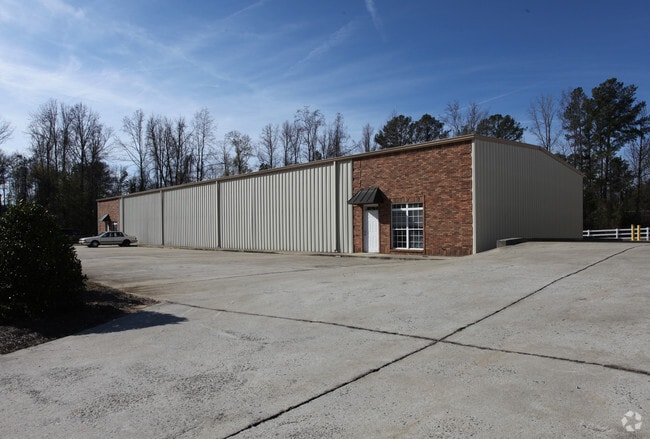

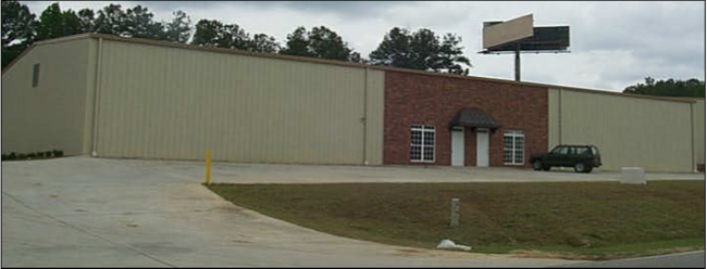
Property Detail
4375 Interstate Dr
K008-0220
Bibb
Industrialgeneral
Georgia
PDI
74
B and X Area of moderate flood hazard, usually the area between the limits of the 100-year and 500-year floods.
3.77 AC
2025
Outlying Bibb County
2025
Atlanta
013201
Macon-Bibb County, GA
7,500 SF
NEARBY LISTINGS FOR SALE OR LEASE
DEMOGRAPHICS near 4375 Interstate Dr
1 mile
3 mile
5 mile
2025 Total Population
3,617
28,588
87,783
2030 Population
3,603
28,827
88,317
Pop Growth 2025-2030
(0.39%)
+ 0.84%
+ 0.61%
Average Age
36
37
38
2025 Total Households
1,469
11,062
34,397
HH Growth 2025-2030
(0.68%)
+ 0.68%
+ 0.66%
Median Household Inc
$56,605
$44,116
$50,741
Avg Household Size
2.50
2.50
2.40
2025 Avg HH Vehicles
2.00
2.00
2.00
Median Home Value
$161,245
$163,967
$188,792
Median Year Built
1987
1978
1974
Nearby Places
Map Layers
Map Styles
 Street
 Aerial
Transit
 Traffic
 Biking
Places
Listings with unknown addresses are not visible on the map
- Restaurants
- Banks
- Shops
- Fitness
- Groceries
SALE & LEASE HISTORY
LISTING DATE
SALE/LEASE

Oct 28, 2025
For Lease
Nearby Properties
Address
Land Use
TOTAL SIZE
Lot Size
Zoning
Address
Land Use
TOTAL SIZE
Lot Size
Zoning
17,812 SF
161.34 AC
A/C-4
Address
Land Use
TOTAL SIZE
Lot Size
Zoning
24,207 SF
21.84 AC
PDE
Address
Land Use
TOTAL SIZE
Lot Size
Zoning
18,900 SF
25.25 AC
C-2
Address
Land Use
TOTAL SIZE
Lot Size
Zoning
170,536 SF
51.47 AC
A
Address
Land Use
TOTAL SIZE
Lot Size
Zoning
214,685 SF
18.69 AC
C-2
Address
Land Use
TOTAL SIZE
Lot Size
Zoning
1,428 SF
64.46 AC
R-1A
Address
Land Use
TOTAL SIZE
Lot Size
Zoning
20,544 SF
62.02 AC
A
Address
Land Use
TOTAL SIZE
Lot Size
Zoning
10,500 SF
12.69 AC
C-4
Address
Land Use
TOTAL SIZE
Lot Size
Zoning
2,070 SF
24.17 AC
PDR
Address
Land Use
TOTAL SIZE
Lot Size
Zoning
3,025 SF
23.37 AC
R-3
Address
Land Use
TOTAL SIZE
Lot Size
Zoning
86,912 SF
5.39 AC
PDE
Address
Land Use
TOTAL SIZE
Lot Size
Zoning
89,814 SF
16.60 AC
R-1A
Address
Land Use
TOTAL SIZE
Lot Size
Zoning
85,556 SF
10.50 AC
R-1A
Address
Land Use
TOTAL SIZE
Lot Size
Zoning
2,766 SF
10.96 AC
R-3
Address
Land Use
TOTAL SIZE
Lot Size
Zoning
3,268 SF
9.29 AC
R-3
Address
Land Use
TOTAL SIZE
Lot Size
Zoning
123,163 SF
47.31 AC
PDE
Address
Land Use
TOTAL SIZE
Lot Size
Zoning
202,057 SF
33.05 AC
C-4
Address
Land Use
TOTAL SIZE
Lot Size
Zoning
40,560 SF
19.20 AC
R-2
Address
Land Use
TOTAL SIZE
Lot Size
Zoning
96,512 SF
11.30 AC
PDE
Address
Land Use
TOTAL SIZE
Lot Size
Zoning
3,860 SF
22 AC
PDE
Address
Land Use
TOTAL SIZE
Lot Size
Zoning
28,755 SF
70 AC
PDE
Address
Land Use
TOTAL SIZE
Lot Size
Zoning
6,560 SF
17 AC
PDE
Address
Land Use
TOTAL SIZE
Lot Size
Zoning
133,862 SF
25.44 AC
C-2
Address
Land Use
TOTAL SIZE
Lot Size
Zoning
69,184 SF
12.67 AC
C-2
Address
Land Use
TOTAL SIZE
Lot Size
Zoning
14,596 SF
9.45 AC
A
Address
Land Use
TOTAL SIZE
Lot Size
Zoning
105,247 SF
12.27 AC
C-2
Address
Land Use
TOTAL SIZE
Lot Size
Zoning
2,856 SF
20.50 AC
A
Address
Land Use
TOTAL SIZE
Lot Size
Zoning
132,423 SF
20.38 AC
C-2
Address
Land Use
TOTAL SIZE
Lot Size
Zoning
20,572 SF
16.08 AC
R-3
Address
Land Use
TOTAL SIZE
Lot Size
Zoning
54,810 SF
2.17 AC
C-4
The World's #1 Commercial Real Estate Marketplace
Connect with us
© 2026 CoStar Group
The information above has been obtained from sources believed reliable. While we do not doubt its accuracy we have not verified it and make no guarantee, warranty or representation about it. It is your responsibility to independently confirm its accuracy and completeness. Any projections, opinions, assumptions, or estimates used are for example only and do not represent the current or future performance of the property. The value of this transaction to you depends on tax and other factors which should be evaluated by your tax, financial, and legal advisors. You and your advisors should conduct a careful, independent investigation of the property to determine to your satisfaction the suitability of the property for your needs.