Property Record
4379 E Franklin Rd, Nampa, ID 83687
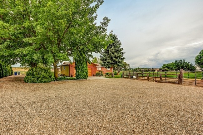


This Property Is For Sale
NEARBY LISTINGS FOR SALE OR LEASE
Property Detail
4379 E Franklin Rd
3044000000
17-3N-1W NE TX 27 IN W 1/2 NWNE LS RD
Sfr
Canyon
X
Idaho
16027C0401F
4.45 AC
2024
Nampa
2025
Boise City/Nampa
020700
Boise City, ID
2,012 SF
DEMOGRAPHICS near 4379 E Franklin Rd
1 mile
3 mile
5 mile
2024 Total Population
802
31,072
131,297
2029 Population
964
36,656
154,266
Pop Growth 2024-2029
+ 20.20%
+ 17.97%
+ 17.49%
Average Age
43
38
37
2024 Total Households
269
11,078
46,113
HH Growth 2024-2029
+ 20.82%
+ 18.22%
+ 17.78%
Median Household Inc
$97,674
$70,894
$73,957
Avg Household Size
2.90
2.70
2.80
2024 Avg HH Vehicles
3.00
2.00
2.00
Median Home Value
$462,903
$401,363
$393,224
Median Year Built
1992
2000
2000
Nearby Places
Map Layers
Map Styles
 Street
 Aerial
Transit
 Traffic
 Biking
Places
Listings with unknown addresses are not visible on the map
- Restaurants
- Banks
- Shops
- Fitness
- Groceries
PUBLIC TRANSPORTATION
AIRPORT
Boise Air Trml/Gowen Field
Drive
Walk
Distance
Boise Air Trml/Gowen Field
35 min
18.9 mi
Freight Ports
Port of Portland
Drive
Walk
Distance
Port of Portland
461 min
418.5 mi
Nearby Properties
Address
Land Use
TOTAL SIZE
Lot Size
Zoning
Address
Land Use
TOTAL SIZE
Lot Size
Zoning
61.03 AC
Address
Land Use
TOTAL SIZE
Lot Size
Zoning
52,235 SF
16.19 AC
Address
Land Use
TOTAL SIZE
Lot Size
Zoning
33.22 AC
M1
Address
Land Use
TOTAL SIZE
Lot Size
Zoning
28.03 AC
M1
Address
Land Use
TOTAL SIZE
Lot Size
Zoning
239,139 SF
38.34 AC
M1
Address
Land Use
TOTAL SIZE
Lot Size
Zoning
263,964 SF
16.29 AC
C-G
Address
Land Use
TOTAL SIZE
Lot Size
Zoning
908 SF
48.85 AC
Address
Land Use
TOTAL SIZE
Lot Size
Zoning
268,802 SF
8.35 AC
R-40
Address
Land Use
TOTAL SIZE
Lot Size
Zoning
239,584 SF
7.83 AC
C-G
Address
Land Use
TOTAL SIZE
Lot Size
Zoning
161,870 SF
8.48 AC
C-G
Address
Land Use
TOTAL SIZE
Lot Size
Zoning
2,222 SF
12.28 AC
RR
Address
Land Use
TOTAL SIZE
Lot Size
Zoning
1,800 SF
103.28 AC
Address
Land Use
TOTAL SIZE
Lot Size
Zoning
95.54 AC
Address
Land Use
TOTAL SIZE
Lot Size
Zoning
144,918 SF
4.95 AC
C-G
Address
Land Use
TOTAL SIZE
Lot Size
Zoning
141,360 SF
30.32 AC
I-L
Address
Land Use
TOTAL SIZE
Lot Size
Zoning
10.44 AC
R-15
Address
Land Use
TOTAL SIZE
Lot Size
Zoning
127,560 SF
4.29 AC
C-G
Address
Land Use
TOTAL SIZE
Lot Size
Zoning
125,241 SF
6.53 AC
C-G
Address
Land Use
TOTAL SIZE
Lot Size
Zoning
3,308 SF
7.06 AC
Address
Land Use
TOTAL SIZE
Lot Size
Zoning
121,306 SF
1.45 AC
C-G
Address
Land Use
TOTAL SIZE
Lot Size
Zoning
164,916 SF
8.89 AC
R-15
Address
Land Use
TOTAL SIZE
Lot Size
Zoning
262,845 SF
11.97 AC
R-15
Address
Land Use
TOTAL SIZE
Lot Size
Zoning
128,063 SF
10.78 AC
R-15
Address
Land Use
TOTAL SIZE
Lot Size
Zoning
149.04 AC
Address
Land Use
TOTAL SIZE
Lot Size
Zoning
136,249 SF
16.36 AC
Address
Land Use
TOTAL SIZE
Lot Size
Zoning
120,500 SF
12.28 AC
I-L
Address
Land Use
TOTAL SIZE
Lot Size
Zoning
18.39 AC
Address
Land Use
TOTAL SIZE
Lot Size
Zoning
83,636 SF
2.54 AC
C-G
Address
Land Use
TOTAL SIZE
Lot Size
Zoning
75,950 SF
5.18 AC
C-G
Address
Land Use
TOTAL SIZE
Lot Size
Zoning
11.74 AC
The World's #1 Commercial Real Estate Marketplace
Connect with us
© 2026 CoStar Group
The information above has been obtained from sources believed reliable. While we do not doubt its accuracy we have not verified it and make no guarantee, warranty or representation about it. It is your responsibility to independently confirm its accuracy and completeness. Any projections, opinions, assumptions, or estimates used are for example only and do not represent the current or future performance of the property. The value of this transaction to you depends on tax and other factors which should be evaluated by your tax, financial, and legal advisors. You and your advisors should conduct a careful, independent investigation of the property to determine to your satisfaction the suitability of the property for your needs.