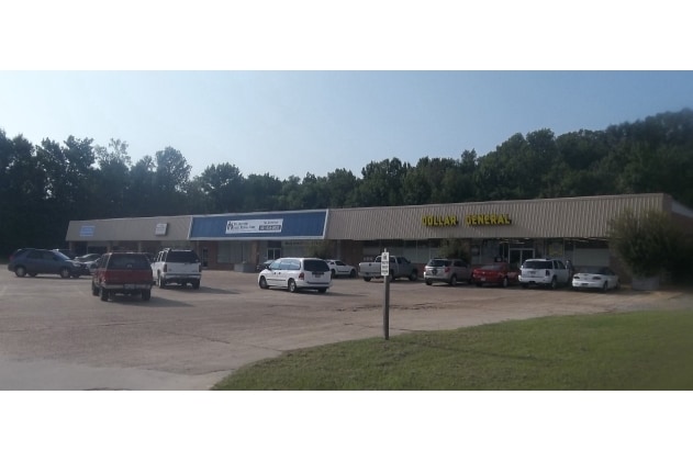
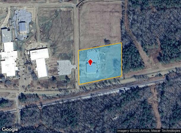
Property Record
4381 Highway 80, Pelahatchie, MS 39145
NEARBY LISTINGS FOR SALE OR LEASE
-
-
View all Pelahatchie listings for sale on LoopNet.com
Property Detail
4381 Highway 80
N09-000064-00020
4.02 AC IN NE4 NW4 & NW4 NE4 N HWY 80
Warehouse
Rankin
AE
Mississippi
28121C0240F
4.02 AC
2024
Outlying Rankin County
2024
Jackson
020105
Jackson, MS
10,106 SF
DEMOGRAPHICS near 4381 Highway 80
1 Mile
3 Mile
5 Mile
2024 Total Population
95
1,936
3,429
2029 Population
98
1,993
3,531
Pop Growth 2024-2029
+ 3.16%
+ 2.94%
+ 2.97%
Average Age
41
41
41
2024 Total Households
34
711
1,259
HH Growth 2024-2029
+ 2.94%
+ 2.95%
+ 3.02%
Median Household Inc
$65,625
$55,076
$57,611
Avg Household Size
2.50
2.70
2.60
2024 Avg HH Vehicles
3.00
2.00
2.00
Median Home Value
$350,000
$186,566
$200,843
Median Year Built
2000
1979
1984
Nearby Places
Map Layers
Map Styles
 Street
 Aerial
- Restaurants
- Banks
- Shops
- Fitness
- Groceries
PUBLIC TRANSPORTATION
AIRPORT
Jackson-Medgar Wiley Evers International
DRIVE
WALK
Distance
Jackson-Medgar Wiley Evers International
28 min
18.0 mi
Freight Ports
Port of Gulf Port
DRIVE
WALK
Distance
Port of Gulf Port
206 min
157.8 mi
Nearby Properties
Address
Land Use
TOTAL SIZE
Lot Size
Zoning
Address
Land Use
TOTAL SIZE
Lot Size
Zoning
268,976 SF
23.12 AC
Address
Land Use
TOTAL SIZE
Lot Size
Zoning
2,526 SF
52.70 AC
Address
Land Use
TOTAL SIZE
Lot Size
Zoning
3,108 SF
9.29 AC
Address
Land Use
TOTAL SIZE
Lot Size
Zoning
6,097 SF
0.12 AC
Address
Land Use
TOTAL SIZE
Lot Size
Zoning
5,696 SF
3.96 AC
Address
Land Use
TOTAL SIZE
Lot Size
Zoning
32,062 SF
6 AC
Address
Land Use
TOTAL SIZE
Lot Size
Zoning
5,636 SF
0.13 AC
Address
Land Use
TOTAL SIZE
Lot Size
Zoning
52,685 SF
5.26 AC
Address
Land Use
TOTAL SIZE
Lot Size
Zoning
4,045 SF
4.07 AC
Address
Land Use
TOTAL SIZE
Lot Size
Zoning
3,920 SF
2.43 AC
Address
Land Use
TOTAL SIZE
Lot Size
Zoning
Address
Land Use
TOTAL SIZE
Lot Size
Zoning
6,118 SF
2.09 AC
Address
Land Use
TOTAL SIZE
Lot Size
Zoning
40,600 SF
10.20 AC
Address
Land Use
TOTAL SIZE
Lot Size
Zoning
16,999 SF
4.20 AC
Address
Land Use
TOTAL SIZE
Lot Size
Zoning
20,111 SF
1.21 AC
Address
Land Use
TOTAL SIZE
Lot Size
Zoning
2,186 SF
4.55 AC
Address
Land Use
TOTAL SIZE
Lot Size
Zoning
1,492 SF
2 AC
Address
Land Use
TOTAL SIZE
Lot Size
Zoning
18,174 SF
4 AC
Address
Land Use
TOTAL SIZE
Lot Size
Zoning
6,615 SF
2.20 AC
Address
Land Use
TOTAL SIZE
Lot Size
Zoning
6,593 SF
0.33 AC
Address
Land Use
TOTAL SIZE
Lot Size
Zoning
1,929 SF
0.15 AC
Address
Land Use
TOTAL SIZE
Lot Size
Zoning
Address
Land Use
TOTAL SIZE
Lot Size
Zoning
7,452 SF
4.66 AC
Address
Land Use
TOTAL SIZE
Lot Size
Zoning
5,948 SF
0.31 AC
Address
Land Use
TOTAL SIZE
Lot Size
Zoning
15,012 SF
3.93 AC
Address
Land Use
TOTAL SIZE
Lot Size
Zoning
1,084 SF
0.13 AC
Address
Land Use
TOTAL SIZE
Lot Size
Zoning
2,864 SF
1.07 AC
Address
Land Use
TOTAL SIZE
Lot Size
Zoning
6,036 SF
1.26 AC
Address
Land Use
TOTAL SIZE
Lot Size
Zoning
Address
Land Use
TOTAL SIZE
Lot Size
Zoning
2,613 SF
2 AC
The World's #1 Commercial Real Estate Marketplace
Connect with us
© 2026 CoStar Group
The information above has been obtained from sources believed reliable. While we do not doubt its accuracy we have not verified it and make no guarantee, warranty or representation about it. It is your responsibility to independently confirm its accuracy and completeness. Any projections, opinions, assumptions, or estimates used are for example only and do not represent the current or future performance of the property. The value of this transaction to you depends on tax and other factors which should be evaluated by your tax, financial, and legal advisors. You and your advisors should conduct a careful, independent investigation of the property to determine to your satisfaction the suitability of the property for your needs.