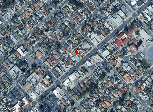
Property Record
439 N Maclay Ave, San Fernando, CA 91340
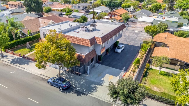
This Property Is For Sale
NEARBY LISTINGS FOR SALE OR LEASE
Property Detail
439 N Maclay Ave
Los Angeles-Long Beach-Glendale, CA
1214
2518-008-016
TRACT # 1214 SW 10 FT OF LOT 16 AND ALL OF LOT 17
Officebuilding
Los Angeles
X
California
06037C1075G
16,17
2024
0.19 AC
2025
Eastern SFV
320202
Los Angeles
4,481 SF
DEMOGRAPHICS near 439 N Maclay Ave
1 Mile
3 Mile
5 Mile
2024 Total Population
30,088
202,694
412,821
2029 Population
28,793
194,211
398,427
Pop Growth 2024-2029
(4.30%)
(4.19%)
(3.49%)
Average Age
37
38
38
2024 Total Households
7,519
50,825
109,981
HH Growth 2024-2029
(4.64%)
(4.45%)
(3.71%)
Median Household Inc
$67,510
$77,280
$76,511
Avg Household Size
3.80
3.70
3.60
2024 Avg HH Vehicles
2.00
2.00
2.00
Median Home Value
$658,354
$645,142
$683,157
Median Year Built
1957
1964
1965
Nearby Places
- Restaurants
- Banks
- Shops
- Fitness
- Groceries
PUBLIC TRANSPORTATION
COMMUTER RAIL
Sylmar/San Fernando (Antelope Valley Line - Southern California Regional Rail Authority (Metrolink))
DRIVE
WALK
Distance
Sylmar/San Fernando (Antelope Valley Line - Southern California Regional Rail Authority (Metrolink))
3 min
1.5 mi
Van Nuys (Ventura County Line - Southern California Regional Rail Authority (Metrolink))
DRIVE
WALK
Distance
Van Nuys (Ventura County Line - Southern California Regional Rail Authority (Metrolink))
11 min
6.3 mi
AIRPORT
Bob Hope
DRIVE
WALK
Distance
Bob Hope
14 min
8.1 mi
Los Angeles International
DRIVE
WALK
Distance
Los Angeles International
38 min
28.4 mi
Freight Ports
Port of Long Beach
DRIVE
WALK
Distance
Port of Long Beach
60 min
47.7 mi
Nearby Properties
Address
Land Use
TOTAL SIZE
Lot Size
Zoning
Address
Land Use
TOTAL SIZE
Lot Size
Zoning
237,451 SF
13.93 AC
LAA2
Address
Land Use
TOTAL SIZE
Lot Size
Zoning
124,418 SF
6.80 AC
LAC1
Address
Land Use
TOTAL SIZE
Lot Size
Zoning
154,631 SF
11.62 AC
LAC2
Address
Land Use
TOTAL SIZE
Lot Size
Zoning
302,813 SF
13.10 AC
LAM1
Address
Land Use
TOTAL SIZE
Lot Size
Zoning
Address
Land Use
TOTAL SIZE
Lot Size
Zoning
196,404 SF
10.06 AC
LARD1.5
Address
Land Use
TOTAL SIZE
Lot Size
Zoning
185,568 SF
9.06 AC
LARD1.5
Address
Land Use
TOTAL SIZE
Lot Size
Zoning
182,309 SF
13.98 AC
LAM1
Address
Land Use
TOTAL SIZE
Lot Size
Zoning
169,259 SF
2.56 AC
LAC1
Address
Land Use
TOTAL SIZE
Lot Size
Zoning
61,315 SF
0.84 AC
LARAS4
Address
Land Use
TOTAL SIZE
Lot Size
Zoning
176,704 SF
4.10 AC
LAR3
Address
Land Use
TOTAL SIZE
Lot Size
Zoning
176,160 SF
3.19 AC
LAR3
Address
Land Use
TOTAL SIZE
Lot Size
Zoning
Address
Land Use
TOTAL SIZE
Lot Size
Zoning
96,792 SF
5.52 AC
LARD2
Address
Land Use
TOTAL SIZE
Lot Size
Zoning
100,967 SF
11.78 AC
LAP
Address
Land Use
TOTAL SIZE
Lot Size
Zoning
150,041 SF
10.46 AC
LAA2
Address
Land Use
TOTAL SIZE
Lot Size
Zoning
105,541 SF
7.29 AC
LARA
Address
Land Use
TOTAL SIZE
Lot Size
Zoning
146,718 SF
7.36 AC
Address
Land Use
TOTAL SIZE
Lot Size
Zoning
146,718 SF
7.11 AC
SFM
Address
Land Use
TOTAL SIZE
Lot Size
Zoning
154,575 SF
12.20 AC
LAM3
Address
Land Use
TOTAL SIZE
Lot Size
Zoning
120,590 SF
9.52 AC
SFM2-C1P*
Address
Land Use
TOTAL SIZE
Lot Size
Zoning
179,394 SF
6.44 AC
LAC1
Address
Land Use
TOTAL SIZE
Lot Size
Zoning
108,012 SF
6.40 AC
LAR3
Address
Land Use
TOTAL SIZE
Lot Size
Zoning
140,411 SF
10.79 AC
LAM3
Address
Land Use
TOTAL SIZE
Lot Size
Zoning
114,758 SF
6.21 AC
LAC2
Address
Land Use
TOTAL SIZE
Lot Size
Zoning
44,480 SF
2.72 AC
LAM2
Address
Land Use
TOTAL SIZE
Lot Size
Zoning
110,096 SF
6.14 AC
LAM2
Address
Land Use
TOTAL SIZE
Lot Size
Zoning
99,966 SF
4.53 AC
LAM1
The World's #1 Commercial Real Estate Marketplace
Connect with us
© 2025 CoStar Group
The information above has been obtained from sources believed reliable. While we do not doubt its accuracy we have not verified it and make no guarantee, warranty or representation about it. It is your responsibility to independently confirm its accuracy and completeness. Any projections, opinions, assumptions, or estimates used are for example only and do not represent the current or future performance of the property. The value of this transaction to you depends on tax and other factors which should be evaluated by your tax, financial, and legal advisors. You and your advisors should conduct a careful, independent investigation of the property to determine to your satisfaction the suitability of the property for your needs.