Property Record
439 Pooler Pky, Pooler, GA 31322
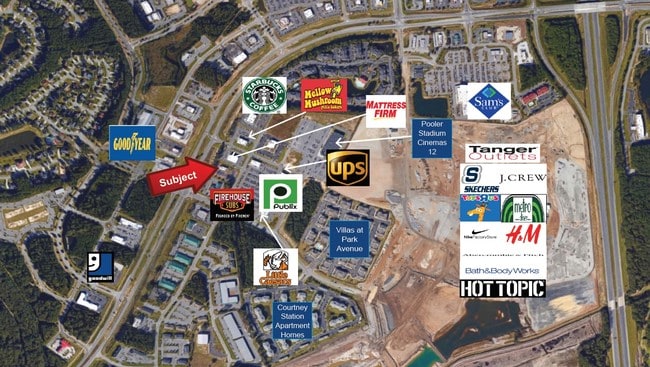

Property Detail
439 Pooler Pky
50017A01088
LOT 4 POOLER MARKET PLACE SUBDI VISION PRB 46P 203 SMB 42S 9
Restaurantdrivein
Chatham
C-2
Georgia
B and X Area of moderate flood hazard, usually the area between the limits of the 100-year and 500-year floods.
4
2025
1.23 AC
2025
Bloomingdale/Pooler
010704
Savannah
2,829 SF
Savannah, GA
NEARBY LISTINGS FOR SALE OR LEASE
DEMOGRAPHICS near 439 Pooler Pky
1 mile
3 mile
5 mile
2025 Total Population
5,832
24,108
53,547
2030 Population
6,069
25,254
56,636
Pop Growth 2025-2030
+ 4.06%
+ 4.75%
+ 5.77%
Average Age
39
38
38
2025 Total Households
2,683
9,681
20,510
HH Growth 2025-2030
+ 4.17%
+ 4.81%
+ 5.82%
Median Household Inc
$90,750
$86,927
$90,463
Avg Household Size
2.10
2.50
2.50
2025 Avg HH Vehicles
2.00
2.00
2.00
Median Home Value
$330,640
$310,510
$316,454
Median Year Built
2005
2006
2007
Nearby Places
Map Layers
Map Styles
 Street
 Aerial
Layers
 Traffic
 Biking
Places
Listings with unknown addresses are not visible on the map
- Restaurants
- Banks
- Shops
- Fitness
- Groceries
PUBLIC TRANSPORTATION
COMMUTER RAIL
Drive
Walk
Distance
19 min
9.8 mi
AIRPORT
Savannah/Hilton Head International
Drive
Walk
Distance
Savannah/Hilton Head International
19 min
8.2 mi
Hilton Head
Drive
Walk
Distance
Hilton Head
57 min
42.4 mi
Freight Ports
Georgia Ports - Savannah
Drive
Walk
Distance
Georgia Ports - Savannah
21 min
8.7 mi
SALE & LEASE HISTORY
LISTING DATE
SALE/LEASE

Sep 28, 2017
For Sale
Sep 07, 2017
For Sale
Nearby Properties
Address
Land Use
TOTAL SIZE
Lot Size
Zoning
Address
Land Use
TOTAL SIZE
Lot Size
Zoning
426,547 SF
15.29 AC
Address
Land Use
TOTAL SIZE
Lot Size
Zoning
432,965 SF
10.09 AC
Address
Land Use
TOTAL SIZE
Lot Size
Zoning
1,080,000 SF
71.17 AC
PUD
Address
Land Use
TOTAL SIZE
Lot Size
Zoning
605,200 SF
59.62 AC
I-H
Address
Land Use
TOTAL SIZE
Lot Size
Zoning
1,460,340 SF
89.96 AC
RA-1
Address
Land Use
TOTAL SIZE
Lot Size
Zoning
1,193,920 SF
84.08 AC
PUD
Address
Land Use
TOTAL SIZE
Lot Size
Zoning
42,338 SF
65.96 AC
PUD
Address
Land Use
TOTAL SIZE
Lot Size
Zoning
1,584 SF
67.35 AC
I1
Address
Land Use
TOTAL SIZE
Lot Size
Zoning
944,260 SF
56.31 AC
I-1
Address
Land Use
TOTAL SIZE
Lot Size
Zoning
754,000 SF
63.38 AC
I-H
Address
Land Use
TOTAL SIZE
Lot Size
Zoning
728,500 SF
67.67 AC
Address
Land Use
TOTAL SIZE
Lot Size
Zoning
710,881 SF
44.98 AC
I-1
Address
Land Use
TOTAL SIZE
Lot Size
Zoning
70.39 AC
Address
Land Use
TOTAL SIZE
Lot Size
Zoning
24,648 SF
23.38 AC
Address
Land Use
TOTAL SIZE
Lot Size
Zoning
631,800 SF
38.47 AC
Address
Land Use
TOTAL SIZE
Lot Size
Zoning
103,840 SF
49.10 AC
I-L
Address
Land Use
TOTAL SIZE
Lot Size
Zoning
2,000 SF
24.74 AC
PUDCC
Address
Land Use
TOTAL SIZE
Lot Size
Zoning
9,505 SF
0.07 AC
Address
Land Use
TOTAL SIZE
Lot Size
Zoning
547,528 SF
67.26 AC
I-1
Address
Land Use
TOTAL SIZE
Lot Size
Zoning
109,284 SF
24.54 AC
R-3-B
Address
Land Use
TOTAL SIZE
Lot Size
Zoning
4,888 SF
37.80 AC
PUDC
Address
Land Use
TOTAL SIZE
Lot Size
Zoning
25,656 SF
23.69 AC
PUDC
Address
Land Use
TOTAL SIZE
Lot Size
Zoning
22,220 SF
27.20 AC
PUDC
Address
Land Use
TOTAL SIZE
Lot Size
Zoning
499,500 SF
28.53 AC
Address
Land Use
TOTAL SIZE
Lot Size
Zoning
499,200 SF
33.02 AC
PUDC
Address
Land Use
TOTAL SIZE
Lot Size
Zoning
35,352 SF
21.22 AC
PUD
Address
Land Use
TOTAL SIZE
Lot Size
Zoning
408 SF
47.25 AC
I-H
Address
Land Use
TOTAL SIZE
Lot Size
Zoning
15,244 SF
36.46 AC
PUDC
Address
Land Use
TOTAL SIZE
Lot Size
Zoning
34,404 SF
20 AC
C2
Address
Land Use
TOTAL SIZE
Lot Size
Zoning
24,555 SF
18.54 AC
PUDC
The World's #1 Commercial Real Estate Marketplace
Connect with us
© 2026 CoStar Group
The information above has been obtained from sources believed reliable. While we do not doubt its accuracy we have not verified it and make no guarantee, warranty or representation about it. It is your responsibility to independently confirm its accuracy and completeness. Any projections, opinions, assumptions, or estimates used are for example only and do not represent the current or future performance of the property. The value of this transaction to you depends on tax and other factors which should be evaluated by your tax, financial, and legal advisors. You and your advisors should conduct a careful, independent investigation of the property to determine to your satisfaction the suitability of the property for your needs.