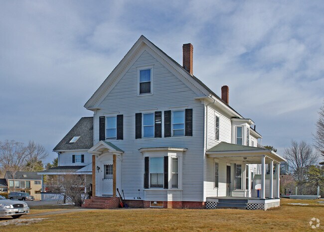
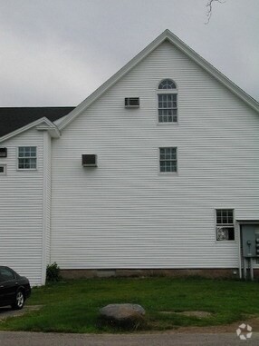
Property Record
439 Route 108, Somersworth, NH 03878
NEARBY LISTINGS FOR SALE OR LEASE
Property Detail
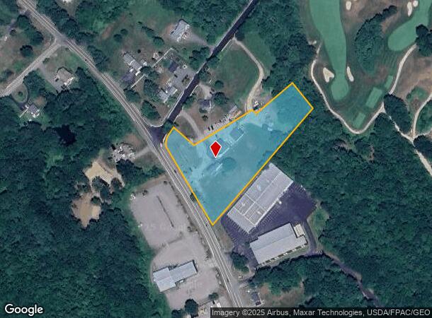
439 Route 108
SMSW-000056-000003
Strafford
Commercialofficeresidentialmixeduse
New Hampshire
X
3.10 AC
33017C0218E
Strafford County
2024
Boston
2024
Boston-Cambridge-Newton, MA-NH
083001
DEMOGRAPHICS near 439 Route 108
1 Mile
3 Mile
5 Mile
2024 Total Population
1,119
20,662
56,178
2029 Population
1,163
21,587
58,809
Pop Growth 2024-2029
+ 3.93%
+ 4.48%
+ 4.68%
Average Age
44
42
41
2024 Total Households
459
8,573
23,153
HH Growth 2024-2029
+ 4.14%
+ 4.51%
+ 4.77%
Median Household Inc
$104,272
$81,865
$87,133
Avg Household Size
2.30
2.40
2.30
2024 Avg HH Vehicles
2.00
2.00
2.00
Median Home Value
$291,176
$267,602
$268,766
Median Year Built
1981
1977
1975
Nearby Places
Map Layers
Map Styles
 Street
 Aerial
- Restaurants
- Banks
- Shops
- Fitness
- Groceries
PUBLIC TRANSPORTATION
AIRPORT
Portsmouth International at Pease
DRIVE
WALK
Distance
Portsmouth International at Pease
29 min
16.0 mi
Nearby Properties
Address
Land Use
TOTAL SIZE
Lot Size
Zoning
Address
Land Use
TOTAL SIZE
Lot Size
Zoning
50.50 AC
R2
Address
Land Use
TOTAL SIZE
Lot Size
Zoning
345,277 SF
49.30 AC
IND
Address
Land Use
TOTAL SIZE
Lot Size
Zoning
19.55 AC
B
Address
Land Use
TOTAL SIZE
Lot Size
Zoning
428,428 SF
210.42 AC
CI
Address
Land Use
TOTAL SIZE
Lot Size
Zoning
Address
Land Use
TOTAL SIZE
Lot Size
Zoning
112,173 SF
21 AC
CI
Address
Land Use
TOTAL SIZE
Lot Size
Zoning
77,916 SF
6.58 AC
A
Address
Land Use
TOTAL SIZE
Lot Size
Zoning
104,186 SF
21.50 AC
CI
Address
Land Use
TOTAL SIZE
Lot Size
Zoning
2.41 AC
Address
Land Use
TOTAL SIZE
Lot Size
Zoning
14.50 AC
CI
Address
Land Use
TOTAL SIZE
Lot Size
Zoning
49,146 SF
7.10 AC
R2
Address
Land Use
TOTAL SIZE
Lot Size
Zoning
150,000 SF
29.85 AC
IND
Address
Land Use
TOTAL SIZE
Lot Size
Zoning
46.98 AC
CI
Address
Land Use
TOTAL SIZE
Lot Size
Zoning
59,160 SF
10.44 AC
R1
Address
Land Use
TOTAL SIZE
Lot Size
Zoning
33.57 AC
CI
Address
Land Use
TOTAL SIZE
Lot Size
Zoning
4,916 SF
93 AC
A
Address
Land Use
TOTAL SIZE
Lot Size
Zoning
12 AC
R2
Address
Land Use
TOTAL SIZE
Lot Size
Zoning
82,752 SF
9.88 AC
R2
Address
Land Use
TOTAL SIZE
Lot Size
Zoning
44,530 SF
2.03 AC
A
Address
Land Use
TOTAL SIZE
Lot Size
Zoning
44,530 SF
5.67 AC
A
Address
Land Use
TOTAL SIZE
Lot Size
Zoning
90,112 SF
7.88 AC
CI
Address
Land Use
TOTAL SIZE
Lot Size
Zoning
6.10 AC
R2
Address
Land Use
TOTAL SIZE
Lot Size
Zoning
289 AC
IND
Address
Land Use
TOTAL SIZE
Lot Size
Zoning
78,615 SF
4.90 AC
MY
Address
Land Use
TOTAL SIZE
Lot Size
Zoning
40,091 SF
5.12 AC
A
Address
Land Use
TOTAL SIZE
Lot Size
Zoning
40,091 SF
1.85 AC
A
Address
Land Use
TOTAL SIZE
Lot Size
Zoning
195,757 SF
27.47 AC
IND
Address
Land Use
TOTAL SIZE
Lot Size
Zoning
3.87 AC
CI
Address
Land Use
TOTAL SIZE
Lot Size
Zoning
55,696 SF
174 AC
AS
Address
Land Use
TOTAL SIZE
Lot Size
Zoning
19,382 SF
7.90 AC
V/C
The World's #1 Commercial Real Estate Marketplace
Connect with us
© 2025 CoStar Group
The information above has been obtained from sources believed reliable. While we do not doubt its accuracy we have not verified it and make no guarantee, warranty or representation about it. It is your responsibility to independently confirm its accuracy and completeness. Any projections, opinions, assumptions, or estimates used are for example only and do not represent the current or future performance of the property. The value of this transaction to you depends on tax and other factors which should be evaluated by your tax, financial, and legal advisors. You and your advisors should conduct a careful, independent investigation of the property to determine to your satisfaction the suitability of the property for your needs.