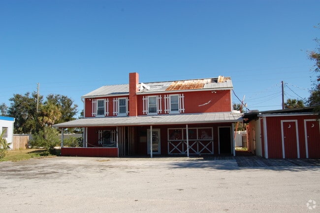
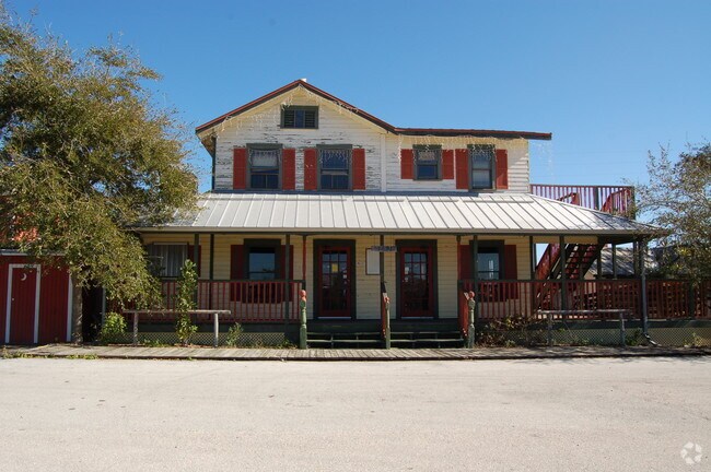
Property Record
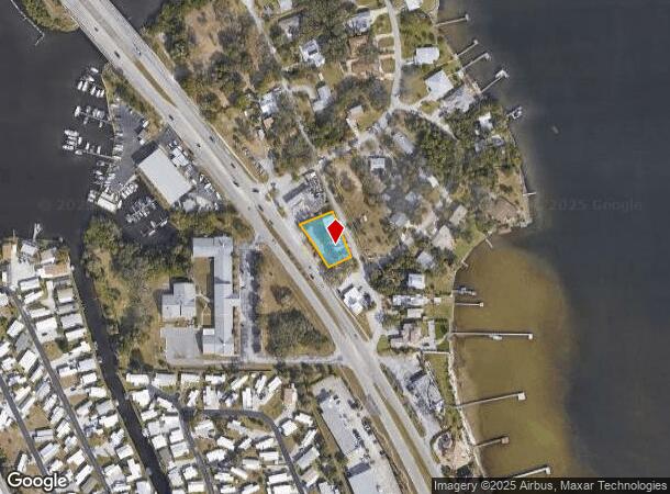
4391 Dixie Hwy Ne, Palm Bay, FL 32905

NEARBY LISTINGS FOR SALE OR LEASE
Property Detail
4391 Dixie Hwy Ne
Palm Bay-Melbourne-Titusville, FL
Hopsons Subd
28-37-24-29-00000.0-0010.00
HOPSONS SUBD PART OF LOT 10 AS DES IN DB 74 PG 37,249 PG 434 EX HWY R/W
Bartavern
Brevard
X
Florida
12009C0612H
10
2024
0.30 AC
2025
Brevard County
065201
Orlando
4,965 SF
DEMOGRAPHICS near 4391 Dixie Hwy Ne
1 Mile
3 Mile
5 Mile
2024 Total Population
3,947
37,550
93,790
2029 Population
4,296
41,436
103,321
Pop Growth 2024-2029
+ 8.84%
+ 10.35%
+ 10.16%
Average Age
45
46
45
2024 Total Households
1,721
16,511
40,981
HH Growth 2024-2029
+ 8.72%
+ 10.21%
+ 10.06%
Median Household Inc
$55,023
$51,035
$51,429
Avg Household Size
2.20
2.20
2.20
2024 Avg HH Vehicles
2.00
2.00
2.00
Median Home Value
$182,987
$233,123
$244,902
Median Year Built
1975
1983
1985
Nearby Places
Map Layers
Map Styles
 Street
 Aerial
- Restaurants
- Banks
- Shops
- Fitness
- Groceries
PUBLIC TRANSPORTATION
AIRPORT
Melbourne Orlando International
DRIVE
WALK
Distance
Melbourne Orlando International
17 min
7.5 mi
Freight Ports
Port Canaveral
DRIVE
WALK
Distance
Port Canaveral
56 min
31.2 mi
Nearby Properties
Address
Land Use
TOTAL SIZE
Lot Size
Zoning
Address
Land Use
TOTAL SIZE
Lot Size
Zoning
1,695,838 SF
106.06 AC
Address
Land Use
TOTAL SIZE
Lot Size
Zoning
408,025 SF
15.72 AC
Address
Land Use
TOTAL SIZE
Lot Size
Zoning
292,165 SF
24.39 AC
RM15
Address
Land Use
TOTAL SIZE
Lot Size
Zoning
368,326 SF
14.77 AC
C1
Address
Land Use
TOTAL SIZE
Lot Size
Zoning
342,276 SF
12.53 AC
LI
Address
Land Use
TOTAL SIZE
Lot Size
Zoning
326,454 SF
14.20 AC
RM20
Address
Land Use
TOTAL SIZE
Lot Size
Zoning
393,147 SF
38.03 AC
RM20
Address
Land Use
TOTAL SIZE
Lot Size
Zoning
39.75 AC
GML
Address
Land Use
TOTAL SIZE
Lot Size
Zoning
201,017 SF
13.77 AC
RM20
Address
Land Use
TOTAL SIZE
Lot Size
Zoning
330,705 SF
25 AC
I1
Address
Land Use
TOTAL SIZE
Lot Size
Zoning
309,725 SF
14.70 AC
R2 (6)
Address
Land Use
TOTAL SIZE
Lot Size
Zoning
560,257 SF
118.47 AC
LI
Address
Land Use
TOTAL SIZE
Lot Size
Zoning
2,366 SF
32.43 AC
SR
Address
Land Use
TOTAL SIZE
Lot Size
Zoning
205,308 SF
11.04 AC
RM20
Address
Land Use
TOTAL SIZE
Lot Size
Zoning
4,000 SF
12.20 AC
IU
Address
Land Use
TOTAL SIZE
Lot Size
Zoning
1,380 SF
21.87 AC
IU
Address
Land Use
TOTAL SIZE
Lot Size
Zoning
762 SF
49.89 AC
GML
Address
Land Use
TOTAL SIZE
Lot Size
Zoning
408,025 SF
24.10 AC
LI
Address
Land Use
TOTAL SIZE
Lot Size
Zoning
136,201 SF
11.93 AC
RM20
Address
Land Use
TOTAL SIZE
Lot Size
Zoning
242,454 SF
14.13 AC
LI
Address
Land Use
TOTAL SIZE
Lot Size
Zoning
135,917 SF
2.92 AC
HC
Address
Land Use
TOTAL SIZE
Lot Size
Zoning
23,945 SF
142.13 AC
GML
Address
Land Use
TOTAL SIZE
Lot Size
Zoning
166,648 SF
13.01 AC
RM20
Address
Land Use
TOTAL SIZE
Lot Size
Zoning
125.01 AC
Address
Land Use
TOTAL SIZE
Lot Size
Zoning
222,925 SF
12.75 AC
PUD
Address
Land Use
TOTAL SIZE
Lot Size
Zoning
76,534 SF
4.33 AC
HC
Address
Land Use
TOTAL SIZE
Lot Size
Zoning
202,908 SF
34.94 AC
LI
Address
Land Use
TOTAL SIZE
Lot Size
Zoning
48,492 SF
17.45 AC
OI
Address
Land Use
TOTAL SIZE
Lot Size
Zoning
168,346 SF
12.52 AC
LI
Address
Land Use
TOTAL SIZE
Lot Size
Zoning
109,650 SF
10.32 AC
CG
The World's #1 Commercial Real Estate Marketplace
Connect with us
© 2026 CoStar Group
The information above has been obtained from sources believed reliable. While we do not doubt its accuracy we have not verified it and make no guarantee, warranty or representation about it. It is your responsibility to independently confirm its accuracy and completeness. Any projections, opinions, assumptions, or estimates used are for example only and do not represent the current or future performance of the property. The value of this transaction to you depends on tax and other factors which should be evaluated by your tax, financial, and legal advisors. You and your advisors should conduct a careful, independent investigation of the property to determine to your satisfaction the suitability of the property for your needs.