Property Record
4393 Commons Dr E, Destin, FL 32541
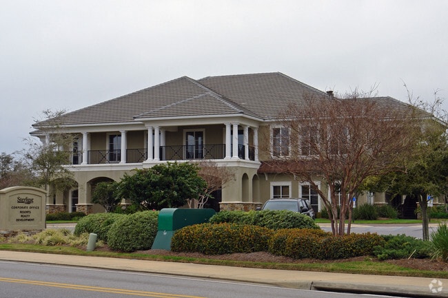


Property Detail
4393 Commons Dr E
Crestview-Fort Walton Beach-Destin, FL
COM NE COR LOT 1 CARRIAGE PLACE AT KELLY PLANTATION S87 DEG E 103FT TO W R/W KELLY PLANTATION DR THC N ALG R/W 40FT S57 DEG E 166FT TO E R/W OF DRIVE THC S ALG R/W 815FT TO POB S83 DEG E 753.19FT S39 DEG E 158.76FT S35 DEG W 77.65 FT S62 DEG E 131.89
00-2S-22-0000-0001-B17B
Okaloosa
Officebuilding
Florida
B and X Area of moderate flood hazard, usually the area between the limits of the 100-year and 500-year floods.
1
2025
3.12 AC
2025
Fort Walton Beach
023304
Other Market Areas
6,832 SF
NEARBY LISTINGS FOR SALE OR LEASE
DEMOGRAPHICS near 4393 Commons Dr E
1 mile
3 mile
5 mile
2024 Total Population
3,903
21,970
35,916
2029 Population
4,355
24,633
40,486
Pop Growth 2024-2029
+ 11.58%
+ 12.12%
+ 12.72%
Average Age
46
45
47
2024 Total Households
1,852
10,026
16,518
HH Growth 2024-2029
+ 11.39%
+ 12.46%
+ 13.23%
Median Household Inc
$113,379
$98,885
$97,157
Avg Household Size
2.10
2.20
2.10
2024 Avg HH Vehicles
2.00
2.00
2.00
Median Home Value
$830,729
$671,010
$565,509
Median Year Built
2007
1999
1997
Nearby Places
Map Layers
Map Styles
 Street
 Aerial
Transit
 Traffic
 Biking
Places
Listings with unknown addresses are not visible on the map
- Restaurants
- Banks
- Shops
- Fitness
- Groceries
PUBLIC TRANSPORTATION
AIRPORT
Eglin AFB/Destin-Ft Walton Beach
Drive
Walk
Distance
Eglin AFB/Destin-Ft Walton Beach
47 min
18.5 mi
SALE & LEASE HISTORY
LISTING DATE
SALE/LEASE

Oct 18, 2017
For Lease
Nearby Properties
Address
Land Use
TOTAL SIZE
Lot Size
Zoning
Address
Land Use
TOTAL SIZE
Lot Size
Zoning
233,598 SF
213.03 AC
Address
Land Use
TOTAL SIZE
Lot Size
Zoning
619,795 SF
47.80 AC
Address
Land Use
TOTAL SIZE
Lot Size
Zoning
110,181 SF
3.48 AC
Address
Land Use
TOTAL SIZE
Lot Size
Zoning
335,190 SF
10.36 AC
Address
Land Use
TOTAL SIZE
Lot Size
Zoning
148,945 SF
12.83 AC
Address
Land Use
TOTAL SIZE
Lot Size
Zoning
125,459 SF
12.57 AC
Address
Land Use
TOTAL SIZE
Lot Size
Zoning
29,385 SF
211.96 AC
Address
Land Use
TOTAL SIZE
Lot Size
Zoning
135,360 SF
16 AC
Address
Land Use
TOTAL SIZE
Lot Size
Zoning
181,240 SF
11.20 AC
Address
Land Use
TOTAL SIZE
Lot Size
Zoning
5.19 AC
GULFFR
Address
Land Use
TOTAL SIZE
Lot Size
Zoning
19,401 SF
6.66 AC
Address
Land Use
TOTAL SIZE
Lot Size
Zoning
164,408 SF
7.98 AC
Address
Land Use
TOTAL SIZE
Lot Size
Zoning
53,437 SF
29.97 AC
Address
Land Use
TOTAL SIZE
Lot Size
Zoning
92.71 AC
Address
Land Use
TOTAL SIZE
Lot Size
Zoning
223,790 SF
20.75 AC
Address
Land Use
TOTAL SIZE
Lot Size
Zoning
195,622 SF
17.68 AC
Address
Land Use
TOTAL SIZE
Lot Size
Zoning
124,578 SF
13.85 AC
Address
Land Use
TOTAL SIZE
Lot Size
Zoning
135,154 SF
15.22 AC
Address
Land Use
TOTAL SIZE
Lot Size
Zoning
56,375 SF
3.51 AC
Address
Land Use
TOTAL SIZE
Lot Size
Zoning
28,327 SF
1.45 AC
Address
Land Use
TOTAL SIZE
Lot Size
Zoning
66,001 SF
1.25 AC
HWY 98
Address
Land Use
TOTAL SIZE
Lot Size
Zoning
113,053 SF
7.25 AC
Address
Land Use
TOTAL SIZE
Lot Size
Zoning
36,890 SF
2.23 AC
Address
Land Use
TOTAL SIZE
Lot Size
Zoning
231,112 SF
23.03 AC
Address
Land Use
TOTAL SIZE
Lot Size
Zoning
6,630 SF
25.69 AC
Address
Land Use
TOTAL SIZE
Lot Size
Zoning
49,123 SF
2.36 AC
Address
Land Use
TOTAL SIZE
Lot Size
Zoning
201,131 SF
11.29 AC
Address
Land Use
TOTAL SIZE
Lot Size
Zoning
154,725 SF
15.69 AC
Address
Land Use
TOTAL SIZE
Lot Size
Zoning
33,420 SF
2.56 AC
Address
Land Use
TOTAL SIZE
Lot Size
Zoning
56,505 SF
2.34 AC
The World's #1 Commercial Real Estate Marketplace
Connect with us
© 2026 CoStar Group
The information above has been obtained from sources believed reliable. While we do not doubt its accuracy we have not verified it and make no guarantee, warranty or representation about it. It is your responsibility to independently confirm its accuracy and completeness. Any projections, opinions, assumptions, or estimates used are for example only and do not represent the current or future performance of the property. The value of this transaction to you depends on tax and other factors which should be evaluated by your tax, financial, and legal advisors. You and your advisors should conduct a careful, independent investigation of the property to determine to your satisfaction the suitability of the property for your needs.