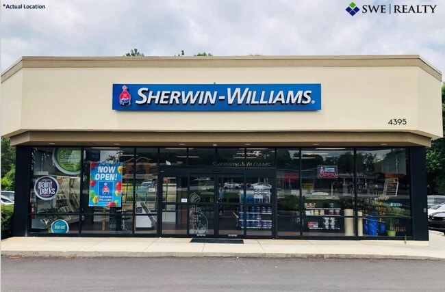
Property Record
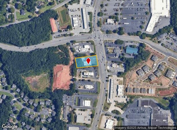
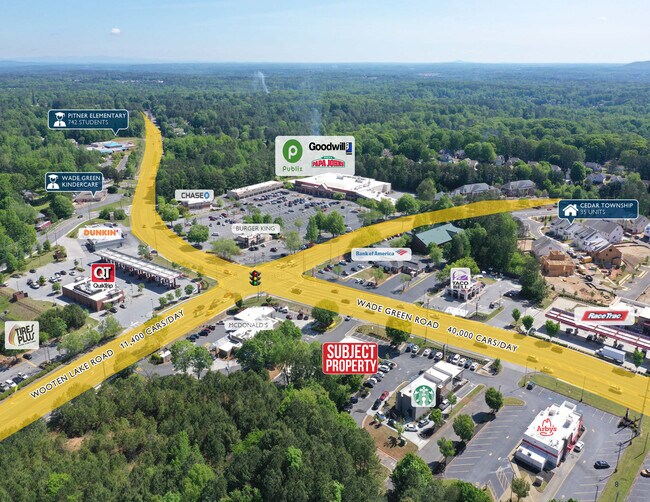
4395 Wade Green Rd Nw, Kennesaw, GA 30144
NEARBY LISTINGS FOR SALE OR LEASE
Property Detail
4395 Wade Green Rd Nw
20-0055-0-212-0
20Th District 2Nd Section
Storebuilding
Cobb
X
Georgia
13057C0350E
55
2025
0.59 AC
2025
Town Center/Marietta
030274
Atlanta
3,192 SF
Atlanta-Sandy Springs-Roswell, GA
DEMOGRAPHICS near 4395 Wade Green Rd Nw
1 Mile
3 Mile
5 Mile
2024 Total Population
10,257
82,654
194,084
2029 Population
10,327
86,094
204,844
Pop Growth 2024-2029
+ 0.68%
+ 4.16%
+ 5.54%
Average Age
37
37
38
2024 Total Households
3,925
29,428
72,581
HH Growth 2024-2029
+ 0.66%
+ 4.21%
+ 5.60%
Median Household Inc
$88,232
$85,123
$84,278
Avg Household Size
2.60
2.60
2.60
2024 Avg HH Vehicles
2.00
2.00
2.00
Median Home Value
$251,589
$279,700
$283,686
Median Year Built
1992
1993
1994
Nearby Places
Map Layers
Map Styles
 Street
 Aerial
- Restaurants
- Banks
- Shops
- Fitness
- Groceries
SALE & LEASE HISTORY
LISTING DATE
SALE/LEASE

Nov 10, 2020
For Sale
May 17, 2023
For Sale
Jun 15, 2022
For Sale
Nearby Properties
Address
Land Use
TOTAL SIZE
Lot Size
Zoning
Address
Land Use
TOTAL SIZE
Lot Size
Zoning
497,466 SF
40.63 AC
RM-12
Address
Land Use
TOTAL SIZE
Lot Size
Zoning
56,439 SF
13.69 AC
GC
Address
Land Use
TOTAL SIZE
Lot Size
Zoning
189,621 SF
12.16 AC
R-40
Address
Land Use
TOTAL SIZE
Lot Size
Zoning
175,587 SF
17.71 AC
RTH
Address
Land Use
TOTAL SIZE
Lot Size
Zoning
489,796 SF
44.09 AC
RM-12
Address
Land Use
TOTAL SIZE
Lot Size
Zoning
4,812 SF
4.20 AC
PVC
Address
Land Use
TOTAL SIZE
Lot Size
Zoning
416,821 SF
12.96 AC
Address
Land Use
TOTAL SIZE
Lot Size
Zoning
35,085 SF
3.77 AC
RRC
Address
Land Use
TOTAL SIZE
Lot Size
Zoning
95,228 SF
12.97 AC
CBD
Address
Land Use
TOTAL SIZE
Lot Size
Zoning
342,443 SF
19.15 AC
NRC/RM12
Address
Land Use
TOTAL SIZE
Lot Size
Zoning
382,704 SF
18.72 AC
RM-16
Address
Land Use
TOTAL SIZE
Lot Size
Zoning
352,938 SF
19.86 AC
RM-16
Address
Land Use
TOTAL SIZE
Lot Size
Zoning
269,464 SF
2.61 AC
CBD
Address
Land Use
TOTAL SIZE
Lot Size
Zoning
300,369 SF
10.64 AC
Address
Land Use
TOTAL SIZE
Lot Size
Zoning
13.43 AC
OI
Address
Land Use
TOTAL SIZE
Lot Size
Zoning
437,231 SF
5.79 AC
PVC
Address
Land Use
TOTAL SIZE
Lot Size
Zoning
7.53 AC
OI
Address
Land Use
TOTAL SIZE
Lot Size
Zoning
201,331 SF
15.48 AC
RM16
Address
Land Use
TOTAL SIZE
Lot Size
Zoning
3.16 AC
PVC
Address
Land Use
TOTAL SIZE
Lot Size
Zoning
13.46 AC
PVC
Address
Land Use
TOTAL SIZE
Lot Size
Zoning
367,587 SF
26.87 AC
RM-12
Address
Land Use
TOTAL SIZE
Lot Size
Zoning
270,275 SF
21.52 AC
RM-12
Address
Land Use
TOTAL SIZE
Lot Size
Zoning
360,937 SF
32.56 AC
RM-12
Address
Land Use
TOTAL SIZE
Lot Size
Zoning
235,861 SF
31.92 AC
RM10
Address
Land Use
TOTAL SIZE
Lot Size
Zoning
280,546 SF
26.91 AC
RM-12
Address
Land Use
TOTAL SIZE
Lot Size
Zoning
27.25 AC
OS
Address
Land Use
TOTAL SIZE
Lot Size
Zoning
195,033 SF
22.85 AC
RM-8
Address
Land Use
TOTAL SIZE
Lot Size
Zoning
212,038 SF
24.96 AC
RM-8
Address
Land Use
TOTAL SIZE
Lot Size
Zoning
198,423 SF
15.31 AC
OI
Address
Land Use
TOTAL SIZE
Lot Size
Zoning
316,088 SF
18.27 AC
GC
The World's #1 Commercial Real Estate Marketplace
Connect with us
© 2025 CoStar Group
The information above has been obtained from sources believed reliable. While we do not doubt its accuracy we have not verified it and make no guarantee, warranty or representation about it. It is your responsibility to independently confirm its accuracy and completeness. Any projections, opinions, assumptions, or estimates used are for example only and do not represent the current or future performance of the property. The value of this transaction to you depends on tax and other factors which should be evaluated by your tax, financial, and legal advisors. You and your advisors should conduct a careful, independent investigation of the property to determine to your satisfaction the suitability of the property for your needs.