Property Record
44 Eastwoods Dr, Kingston, NY 12401

NEARBY LISTINGS FOR SALE OR LEASE
Property Detail
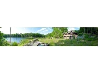
44 Eastwoods Dr
Kingston, NY
Map Of The Town Of Kingston & Part Of Hu
5800-038.002-0001-067.000-0000
Ulster
Miscresidentialimprovement
New York
AE
67.000
36111C0295F
432.80 AC
2025
Newburgh/Kingston
2024
Other Market Areas
952400
DEMOGRAPHICS near 44 Eastwoods Dr
1 Mile
3 Mile
5 Mile
2024 Total Population
360
6,398
20,555
2029 Population
365
6,404
20,676
Pop Growth 2024-2029
+ 1.39%
+ 0.09%
+ 0.59%
Average Age
49
48
47
2024 Total Households
160
2,850
9,080
HH Growth 2024-2029
+ 1.25%
+ 0.18%
+ 0.67%
Median Household Inc
$78,241
$84,854
$78,354
Avg Household Size
2.20
2.20
2.10
2024 Avg HH Vehicles
2.00
2.00
2.00
Median Home Value
$325,000
$328,789
$333,322
Median Year Built
1972
1970
1968
Nearby Places
Map Layers
Map Styles
 Street
 Aerial
- Restaurants
- Banks
- Shops
- Fitness
- Groceries
Nearby Properties
Address
Land Use
TOTAL SIZE
Lot Size
Zoning
Address
Land Use
TOTAL SIZE
Lot Size
Zoning
51,508 SF
34.50 AC
Address
Land Use
TOTAL SIZE
Lot Size
Zoning
15,400 SF
7.43 AC
B1
Address
Land Use
TOTAL SIZE
Lot Size
Zoning
14,956 SF
12.70 AC
R1
Address
Land Use
TOTAL SIZE
Lot Size
Zoning
924 SF
24.60 AC
02 - SINGL
Address
Land Use
TOTAL SIZE
Lot Size
Zoning
10.57 AC
05 - COMME
Address
Land Use
TOTAL SIZE
Lot Size
Zoning
2,380 SF
27.67 AC
R8
Address
Land Use
TOTAL SIZE
Lot Size
Zoning
960 SF
31.10 AC
R
Address
Land Use
TOTAL SIZE
Lot Size
Zoning
8,846 SF
8.90 AC
R1
Address
Land Use
TOTAL SIZE
Lot Size
Zoning
43,455 SF
6.15 AC
LI
Address
Land Use
TOTAL SIZE
Lot Size
Zoning
3,424 SF
29.40 AC
15
Address
Land Use
TOTAL SIZE
Lot Size
Zoning
3,750 SF
36.50 AC
R1
Address
Land Use
TOTAL SIZE
Lot Size
Zoning
2,464 SF
7.30 AC
02 - SINGL
Address
Land Use
TOTAL SIZE
Lot Size
Zoning
2,488 SF
3.60 AC
R1
Address
Land Use
TOTAL SIZE
Lot Size
Zoning
19,635 SF
1.50 AC
R1
Address
Land Use
TOTAL SIZE
Lot Size
Zoning
4,704 SF
R5
Address
Land Use
TOTAL SIZE
Lot Size
Zoning
10,600 SF
4.80 AC
MU1
Address
Land Use
TOTAL SIZE
Lot Size
Zoning
4,236 SF
8.54 AC
02 - SINGL
Address
Land Use
TOTAL SIZE
Lot Size
Zoning
728 SF
10.90 AC
37
Address
Land Use
TOTAL SIZE
Lot Size
Zoning
2.80 AC
R
Address
Land Use
TOTAL SIZE
Lot Size
Zoning
7,692 SF
6.46 AC
R1
Address
Land Use
TOTAL SIZE
Lot Size
Zoning
3,000 SF
4.90 AC
02 - SINGL
Address
Land Use
TOTAL SIZE
Lot Size
Zoning
9,076 SF
5.60 AC
R1
Address
Land Use
TOTAL SIZE
Lot Size
Zoning
119.60 AC
R
Address
Land Use
TOTAL SIZE
Lot Size
Zoning
3,750 SF
38.16 AC
R3
Address
Land Use
TOTAL SIZE
Lot Size
Zoning
3,572 SF
1.48 AC
NC
Address
Land Use
TOTAL SIZE
Lot Size
Zoning
50,385 SF
23.04 AC
R8
Address
Land Use
TOTAL SIZE
Lot Size
Zoning
11,649 SF
3.40 AC
R5
Address
Land Use
TOTAL SIZE
Lot Size
Zoning
3,177 SF
3.80 AC
R1
Address
Land Use
TOTAL SIZE
Lot Size
Zoning
8,134 SF
2.60 AC
R2
The World's #1 Commercial Real Estate Marketplace
Connect with us
© 2026 CoStar Group
The information above has been obtained from sources believed reliable. While we do not doubt its accuracy we have not verified it and make no guarantee, warranty or representation about it. It is your responsibility to independently confirm its accuracy and completeness. Any projections, opinions, assumptions, or estimates used are for example only and do not represent the current or future performance of the property. The value of this transaction to you depends on tax and other factors which should be evaluated by your tax, financial, and legal advisors. You and your advisors should conduct a careful, independent investigation of the property to determine to your satisfaction the suitability of the property for your needs.