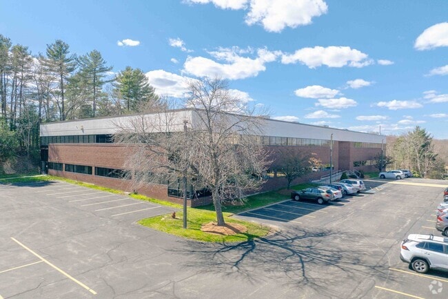
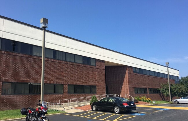
Property Record
44 Manning Rd, Billerica, MA 01821

Save to a Folder
{{folder.Name}}
{{folder.ListingIds.length}} Properties
{{folder.ListingIds.length}} Property
Create a New Folder
Current Lease Availabilities
Property Detail
44 Manning Rd
BILL-000096-000105-000001
Middlesex
Industrialgeneral
Massachusetts
5
1
B and X Area of moderate flood hazard, usually the area between the limits of the 100-year and 500-year floods.
5.40 AC
2025
Lowell/Chelmsford
2025
Boston
316300
Boston-Cambridge-Newton, MA-NH
58,712 SF
NEARBY LISTINGS FOR SALE OR LEASE
DEMOGRAPHICS near 44 Manning Rd
1 mile
3 mile
5 mile
2025 Total Population
4,266
43,838
112,176
2030 Population
4,481
45,516
116,454
Pop Growth 2025-2030
+ 5.04%
+ 3.83%
+ 3.81%
Average Age
43
43
43
2025 Total Households
1,486
15,854
40,005
HH Growth 2025-2030
+ 5.25%
+ 3.97%
+ 3.96%
Median Household Inc
$124,445
$143,552
$148,152
Avg Household Size
2.70
2.70
2.70
2025 Avg HH Vehicles
2.00
2.00
2.00
Median Home Value
$695,418
$728,850
$739,605
Median Year Built
1973
1971
1971
Nearby Places
Map Layers
Map Styles
 Street
 Aerial
Layers
 Traffic
 Biking
Places
Listings with unknown addresses are not visible on the map
- Restaurants
- Banks
- Shops
- Fitness
- Groceries
PUBLIC TRANSPORTATION
COMMUTER RAIL
North Billerica (Lowell Line - Massachusetts Bay Transportation Authority Commuter Rail (Purple Line))
Drive
Walk
Distance
North Billerica (Lowell Line - Massachusetts Bay Transportation Authority Commuter Rail (Purple Line))
14 min
5.9 mi
Wilmington (Lowell Line - Massachusetts Bay Transportation Authority Commuter Rail (Purple Line))
Drive
Walk
Distance
Wilmington (Lowell Line - Massachusetts Bay Transportation Authority Commuter Rail (Purple Line))
18 min
7.8 mi
AIRPORT
General Edward Lawrence Logan International
Drive
Walk
Distance
General Edward Lawrence Logan International
39 min
23.4 mi
Manchester Boston Regional
Drive
Walk
Distance
Manchester Boston Regional
56 min
37.1 mi
Freight Ports
Port of Boston
Drive
Walk
Distance
Port of Boston
40 min
23.2 mi
Nearby Properties
Address
Land Use
TOTAL SIZE
Lot Size
Zoning
Address
Land Use
TOTAL SIZE
Lot Size
Zoning
72,799 SF
69.22 AC
IND
Address
Land Use
TOTAL SIZE
Lot Size
Zoning
135,300 SF
30.85 AC
PD
Address
Land Use
TOTAL SIZE
Lot Size
Zoning
35.90 AC
5
Address
Land Use
TOTAL SIZE
Lot Size
Zoning
253,078 SF
4.18 AC
5
Address
Land Use
TOTAL SIZE
Lot Size
Zoning
32.07 AC
PD
Address
Land Use
TOTAL SIZE
Lot Size
Zoning
325,799 SF
21.70 AC
IND
Address
Land Use
TOTAL SIZE
Lot Size
Zoning
30,480 SF
179 AC
A
Address
Land Use
TOTAL SIZE
Lot Size
Zoning
225,792 SF
9.90 AC
4
Address
Land Use
TOTAL SIZE
Lot Size
Zoning
9.50 AC
Address
Land Use
TOTAL SIZE
Lot Size
Zoning
27.48 AC
5
Address
Land Use
TOTAL SIZE
Lot Size
Zoning
504,154 SF
19.40 AC
2
Address
Land Use
TOTAL SIZE
Lot Size
Zoning
20,382 SF
11.61 AC
IND
Address
Land Use
TOTAL SIZE
Lot Size
Zoning
244,756 SF
15.91 AC
5
Address
Land Use
TOTAL SIZE
Lot Size
Zoning
102,899 SF
28.88 AC
IND
Address
Land Use
TOTAL SIZE
Lot Size
Zoning
16.63 AC
2
Address
Land Use
TOTAL SIZE
Lot Size
Zoning
30,578 SF
13.22 AC
R
Address
Land Use
TOTAL SIZE
Lot Size
Zoning
6.36 AC
5
Address
Land Use
TOTAL SIZE
Lot Size
Zoning
264,936 SF
23.16 AC
IND
Address
Land Use
TOTAL SIZE
Lot Size
Zoning
44,528 SF
23.01 AC
IND
Address
Land Use
TOTAL SIZE
Lot Size
Zoning
345,780 SF
64.77 AC
3
Address
Land Use
TOTAL SIZE
Lot Size
Zoning
2,432 SF
26.58 AC
B
Address
Land Use
TOTAL SIZE
Lot Size
Zoning
201,763 SF
25.39 AC
COM
Address
Land Use
TOTAL SIZE
Lot Size
Zoning
189,450 SF
20.18 AC
IND
Address
Land Use
TOTAL SIZE
Lot Size
Zoning
14,398 SF
29.19 AC
B
Address
Land Use
TOTAL SIZE
Lot Size
Zoning
188,042 SF
32.31 AC
COM
Address
Land Use
TOTAL SIZE
Lot Size
Zoning
85,490 SF
59.36 AC
A
Address
Land Use
TOTAL SIZE
Lot Size
Zoning
25,109 SF
18.90 AC
COM
Address
Land Use
TOTAL SIZE
Lot Size
Zoning
91.75 AC
3
Address
Land Use
TOTAL SIZE
Lot Size
Zoning
88,000 SF
4.86 AC
The World's #1 Commercial Real Estate Marketplace
Connect with us
© 2026 CoStar Group
The information above has been obtained from sources believed reliable. While we do not doubt its accuracy we have not verified it and make no guarantee, warranty or representation about it. It is your responsibility to independently confirm its accuracy and completeness. Any projections, opinions, assumptions, or estimates used are for example only and do not represent the current or future performance of the property. The value of this transaction to you depends on tax and other factors which should be evaluated by your tax, financial, and legal advisors. You and your advisors should conduct a careful, independent investigation of the property to determine to your satisfaction the suitability of the property for your needs.