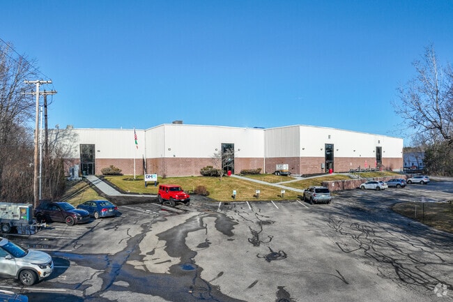
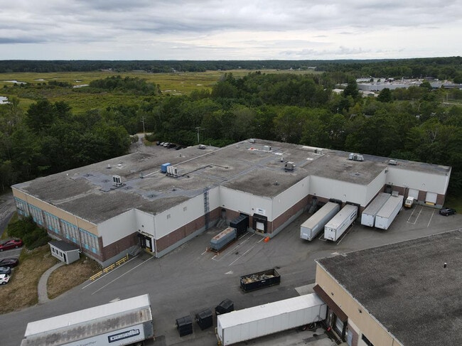
Property Record
44 Manson Libby Rd, Scarborough, ME 04074

NEARBY LISTINGS FOR SALE OR LEASE
Property Detail
44 Manson Libby Rd
SCAR-000062R-000000-000019A
Cumberland
Warehouse
Maine
X
19a
23005C0803F
3 AC
2025
SW Cumberland County
2025
Portland/South Portland
017308
Portland-South Portland, ME
40,056 SF
DEMOGRAPHICS near 44 Manson Libby Rd
1 Mile
3 Mile
5 Mile
2024 Total Population
879
16,099
44,847
2029 Population
925
16,883
47,390
Pop Growth 2024-2029
+ 5.23%
+ 4.87%
+ 5.67%
Average Age
49
45
45
2024 Total Households
375
6,820
19,886
HH Growth 2024-2029
+ 5.33%
+ 5.03%
+ 6.14%
Median Household Inc
$83,768
$94,492
$82,777
Avg Household Size
2.10
2.30
2.20
2024 Avg HH Vehicles
2.00
2.00
2.00
Median Home Value
$431,756
$440,181
$396,424
Median Year Built
1995
1988
1983
Nearby Places
Map Layers
Map Styles
 Street
 Aerial
- Restaurants
- Banks
- Shops
- Fitness
- Groceries
PUBLIC TRANSPORTATION
COMMUTER RAIL
Old Orchard Beach Amtrak (Downeaster - Amtrak)
DRIVE
WALK
Distance
Old Orchard Beach Amtrak (Downeaster - Amtrak)
15 min
7.2 mi
Portland (Downeaster - Amtrak)
DRIVE
WALK
Distance
Portland (Downeaster - Amtrak)
15 min
8.8 mi
AIRPORT
Portland International Jetport
DRIVE
WALK
Distance
Portland International Jetport
16 min
7.5 mi
Freight Ports
Portland, ME
DRIVE
WALK
Distance
Portland, ME
17 min
10.1 mi
SALE & LEASE HISTORY
LISTING DATE
SALE/LEASE

May 24, 2023
For Sale
May 15, 2025
For Sale
Nearby Properties
Address
Land Use
TOTAL SIZE
Lot Size
Zoning
Address
Land Use
TOTAL SIZE
Lot Size
Zoning
28.33 AC
24
Address
Land Use
TOTAL SIZE
Lot Size
Zoning
80,058 SF
14.69 AC
32
Address
Land Use
TOTAL SIZE
Lot Size
Zoning
113,445 SF
12.70 AC
32
Address
Land Use
TOTAL SIZE
Lot Size
Zoning
129,885 SF
28.33 AC
24
Address
Land Use
TOTAL SIZE
Lot Size
Zoning
113,025 SF
7.30 AC
31
Address
Land Use
TOTAL SIZE
Lot Size
Zoning
78,053 SF
9.74 AC
32
Address
Land Use
TOTAL SIZE
Lot Size
Zoning
16 AC
26
Address
Land Use
TOTAL SIZE
Lot Size
Zoning
160,311 SF
19.25 AC
39
Address
Land Use
TOTAL SIZE
Lot Size
Zoning
880 SF
25.60 AC
26
Address
Land Use
TOTAL SIZE
Lot Size
Zoning
79,130 SF
6.06 AC
32
Address
Land Use
TOTAL SIZE
Lot Size
Zoning
109,988 SF
14.51 AC
33
Address
Land Use
TOTAL SIZE
Lot Size
Zoning
2,880 SF
176.89 AC
22
Address
Land Use
TOTAL SIZE
Lot Size
Zoning
Address
Land Use
TOTAL SIZE
Lot Size
Zoning
72,214 SF
22 AC
26
Address
Land Use
TOTAL SIZE
Lot Size
Zoning
11.76 AC
14
Address
Land Use
TOTAL SIZE
Lot Size
Zoning
2.93 AC
Address
Land Use
TOTAL SIZE
Lot Size
Zoning
62,634 SF
8.30 AC
26
Address
Land Use
TOTAL SIZE
Lot Size
Zoning
2,700 SF
54.60 AC
40
Address
Land Use
TOTAL SIZE
Lot Size
Zoning
63,848 SF
6.60 AC
32
Address
Land Use
TOTAL SIZE
Lot Size
Zoning
71,182 SF
18.19 AC
25
Address
Land Use
TOTAL SIZE
Lot Size
Zoning
57,529 SF
7.11 AC
22
Address
Land Use
TOTAL SIZE
Lot Size
Zoning
19,725 SF
45.64 AC
16
Address
Land Use
TOTAL SIZE
Lot Size
Zoning
49,840 SF
24 AC
21
Address
Land Use
TOTAL SIZE
Lot Size
Zoning
103,905 SF
3.79 AC
24
Address
Land Use
TOTAL SIZE
Lot Size
Zoning
48,956 SF
13 AC
15
Address
Land Use
TOTAL SIZE
Lot Size
Zoning
35,714 SF
39.79 AC
MU3
Address
Land Use
TOTAL SIZE
Lot Size
Zoning
49,384 SF
14.01 AC
15
Address
Land Use
TOTAL SIZE
Lot Size
Zoning
49,600 SF
22.06 AC
21
Address
Land Use
TOTAL SIZE
Lot Size
Zoning
1.81 AC
34
Address
Land Use
TOTAL SIZE
Lot Size
Zoning
41,835 SF
3.05 AC
22
The World's #1 Commercial Real Estate Marketplace
Connect with us
© 2025 CoStar Group
The information above has been obtained from sources believed reliable. While we do not doubt its accuracy we have not verified it and make no guarantee, warranty or representation about it. It is your responsibility to independently confirm its accuracy and completeness. Any projections, opinions, assumptions, or estimates used are for example only and do not represent the current or future performance of the property. The value of this transaction to you depends on tax and other factors which should be evaluated by your tax, financial, and legal advisors. You and your advisors should conduct a careful, independent investigation of the property to determine to your satisfaction the suitability of the property for your needs.