Property Record
44 Middleboro Rd, East Freetown, MA 02717
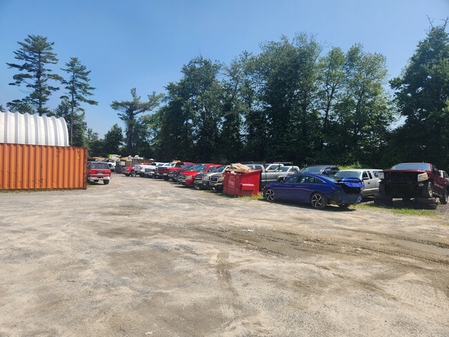
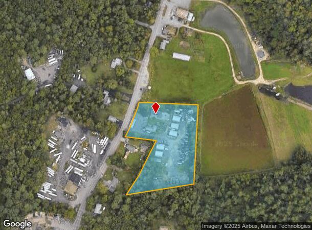


This Property Is For Sale
NEARBY LISTINGS FOR SALE OR LEASE
-
-
View all East Freetown listings for sale on LoopNet.com
Property Detail
44 Middleboro Rd
FREE-000243-000000-000059
Bristol
Commercialofficeresidentialmixeduse
Massachusetts
X
3.70 AC
25005C0289G
Attleboro/New Bedford
2024
Boston
2025
Providence-Warwick, RI-MA
617102
DEMOGRAPHICS near 44 Middleboro Rd
1 Mile
3 Mile
5 Mile
2024 Total Population
1,013
12,317
32,068
2029 Population
1,027
12,598
32,957
Pop Growth 2024-2029
+ 1.38%
+ 2.28%
+ 2.77%
Average Age
43
43
43
2024 Total Households
392
4,739
12,264
HH Growth 2024-2029
+ 1.28%
+ 2.34%
+ 2.80%
Median Household Inc
$123,570
$105,811
$102,138
Avg Household Size
2.60
2.60
2.60
2024 Avg HH Vehicles
2.00
2.00
2.00
Median Home Value
$583,892
$483,728
$466,907
Median Year Built
1967
1976
1975
Nearby Places
Map Layers
Map Styles
 Street
 Aerial
- Restaurants
- Banks
- Shops
- Fitness
- Groceries
PUBLIC TRANSPORTATION
AIRPORT
Rhode Island Tf Green International
DRIVE
WALK
Distance
Rhode Island Tf Green International
62 min
43.1 mi
Freight Ports
Port of New Bedford Harbor
DRIVE
WALK
Distance
Port of New Bedford Harbor
17 min
10.1 mi
Nearby Properties
Address
Land Use
TOTAL SIZE
Lot Size
Zoning
Address
Land Use
TOTAL SIZE
Lot Size
Zoning
75 AC
A/R
Address
Land Use
TOTAL SIZE
Lot Size
Zoning
157,346 SF
5.68 AC
RA
Address
Land Use
TOTAL SIZE
Lot Size
Zoning
44,156 SF
5.18 AC
GI
Address
Land Use
TOTAL SIZE
Lot Size
Zoning
2,834 SF
41.81 AC
OSR
Address
Land Use
TOTAL SIZE
Lot Size
Zoning
199,978 SF
31.41 AC
IC
Address
Land Use
TOTAL SIZE
Lot Size
Zoning
5,500 SF
152 AC
G
Address
Land Use
TOTAL SIZE
Lot Size
Zoning
5,208 SF
152.06 AC
GI
Address
Land Use
TOTAL SIZE
Lot Size
Zoning
118,757 SF
61.52 AC
IC
Address
Land Use
TOTAL SIZE
Lot Size
Zoning
6.34 AC
RA
Address
Land Use
TOTAL SIZE
Lot Size
Zoning
95,972 SF
9.40 AC
IC
Address
Land Use
TOTAL SIZE
Lot Size
Zoning
4,041 SF
31.91 AC
Address
Land Use
TOTAL SIZE
Lot Size
Zoning
51,243 SF
8.51 AC
RA
Address
Land Use
TOTAL SIZE
Lot Size
Zoning
136,521 SF
18.46 AC
IC
Address
Land Use
TOTAL SIZE
Lot Size
Zoning
114,908 SF
14.19 AC
IC
Address
Land Use
TOTAL SIZE
Lot Size
Zoning
71 AC
R
Address
Land Use
TOTAL SIZE
Lot Size
Zoning
39,345 SF
0.79 AC
MUB
Address
Land Use
TOTAL SIZE
Lot Size
Zoning
5,400 SF
38.40 AC
A/R
Address
Land Use
TOTAL SIZE
Lot Size
Zoning
125,184 SF
8.57 AC
IC
Address
Land Use
TOTAL SIZE
Lot Size
Zoning
52,588 SF
3.67 AC
RA
Address
Land Use
TOTAL SIZE
Lot Size
Zoning
76,987 SF
9.18 AC
IC
Address
Land Use
TOTAL SIZE
Lot Size
Zoning
40.10 AC
R
Address
Land Use
TOTAL SIZE
Lot Size
Zoning
82,016 SF
16.40 AC
IC
Address
Land Use
TOTAL SIZE
Lot Size
Zoning
64,309 SF
11.09 AC
IC
Address
Land Use
TOTAL SIZE
Lot Size
Zoning
Address
Land Use
TOTAL SIZE
Lot Size
Zoning
19.79 AC
I
Address
Land Use
TOTAL SIZE
Lot Size
Zoning
144.81 AC
Address
Land Use
TOTAL SIZE
Lot Size
Zoning
51,555 SF
8.74 AC
IC
Address
Land Use
TOTAL SIZE
Lot Size
Zoning
24,240 SF
6.04 AC
GI
Address
Land Use
TOTAL SIZE
Lot Size
Zoning
53,035 SF
9.69 AC
IC
Address
Land Use
TOTAL SIZE
Lot Size
Zoning
13,247 SF
0.74 AC
MUB
The World's #1 Commercial Real Estate Marketplace
Connect with us
© 2026 CoStar Group
The information above has been obtained from sources believed reliable. While we do not doubt its accuracy we have not verified it and make no guarantee, warranty or representation about it. It is your responsibility to independently confirm its accuracy and completeness. Any projections, opinions, assumptions, or estimates used are for example only and do not represent the current or future performance of the property. The value of this transaction to you depends on tax and other factors which should be evaluated by your tax, financial, and legal advisors. You and your advisors should conduct a careful, independent investigation of the property to determine to your satisfaction the suitability of the property for your needs.