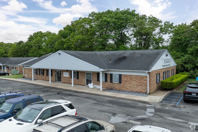
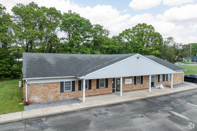
Property Record
450 Waverly Ave, Patchogue, NY 11772
NEARBY LISTINGS FOR SALE OR LEASE
Property Detail
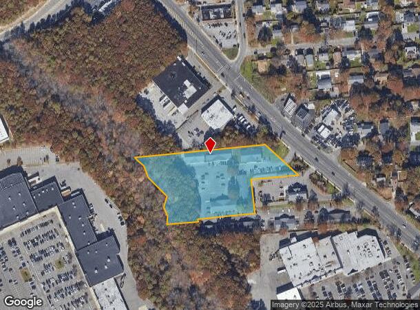
450 Waverly Ave
Nassau County-Suffolk County, NY
Blue Point
0200-973-00-01-00-001-005
N FEDERATION OF OR E L I TRUST S WA
Officebuilding
Suffolk
A
New York
36103C0693H
1
2024
3.15 AC
2024
Central Suffolk
158805
Long Island (New York)
DEMOGRAPHICS near 450 Waverly Ave
1 Mile
3 Mile
5 Mile
2024 Total Population
10,331
83,976
187,312
2029 Population
10,173
83,043
185,182
Pop Growth 2024-2029
(1.53%)
(1.11%)
(1.14%)
Average Age
44
42
42
2024 Total Households
4,338
31,162
65,725
HH Growth 2024-2029
(1.45%)
(1.29%)
(1.34%)
Median Household Inc
$104,363
$110,657
$112,026
Avg Household Size
2.30
2.60
2.70
2024 Avg HH Vehicles
2.00
2.00
2.00
Median Home Value
$443,904
$454,483
$448,611
Median Year Built
1974
1973
1972
Nearby Places
Map Layers
Map Styles
 Street
 Aerial
- Restaurants
- Banks
- Shops
- Fitness
- Groceries
PUBLIC TRANSPORTATION
COMMUTER RAIL
Patchogue Station (Montauk Branch - Long Island Rail Road)
DRIVE
WALK
Distance
Patchogue Station (Montauk Branch - Long Island Rail Road)
5 min
2.1 mi
Medford Station (Greenport Branch - Long Island Rail Road)
DRIVE
WALK
Distance
Medford Station (Greenport Branch - Long Island Rail Road)
9 min
4.8 mi
AIRPORT
Long Island MacArthur
DRIVE
WALK
Distance
Long Island MacArthur
10 min
5.0 mi
Freight Ports
Port of New Haven
DRIVE
WALK
Distance
Port of New Haven
131 min
50.7 mi
SALE & LEASE HISTORY
LISTING DATE
SALE/LEASE

Jan 19, 2022
For Lease
Feb 04, 2025
For Lease
Nearby Properties
Address
Land Use
TOTAL SIZE
Lot Size
Zoning
Address
Land Use
TOTAL SIZE
Lot Size
Zoning
30.25 AC
CA
Address
Land Use
TOTAL SIZE
Lot Size
Zoning
33.47 AC
AA
Address
Land Use
TOTAL SIZE
Lot Size
Zoning
95.19 AC
Address
Land Use
TOTAL SIZE
Lot Size
Zoning
29.86 AC
CA
Address
Land Use
TOTAL SIZE
Lot Size
Zoning
26.28 AC
CA
Address
Land Use
TOTAL SIZE
Lot Size
Zoning
23.50 AC
AA
Address
Land Use
TOTAL SIZE
Lot Size
Zoning
26,811 SF
43.20 AC
CA
Address
Land Use
TOTAL SIZE
Lot Size
Zoning
7,290 SF
15.71 AC
CA
Address
Land Use
TOTAL SIZE
Lot Size
Zoning
96 SF
18.29 AC
BUS3
Address
Land Use
TOTAL SIZE
Lot Size
Zoning
16 AC
AA
Address
Land Use
TOTAL SIZE
Lot Size
Zoning
3,025 SF
5.60 AC
AA
Address
Land Use
TOTAL SIZE
Lot Size
Zoning
23.90 AC
AA
Address
Land Use
TOTAL SIZE
Lot Size
Zoning
12.70 AC
IND1
Address
Land Use
TOTAL SIZE
Lot Size
Zoning
5.01 AC
AA278
Address
Land Use
TOTAL SIZE
Lot Size
Zoning
42.37 AC
Address
Land Use
TOTAL SIZE
Lot Size
Zoning
12.14 AC
BUS3
Address
Land Use
TOTAL SIZE
Lot Size
Zoning
14.73 AC
AA
Address
Land Use
TOTAL SIZE
Lot Size
Zoning
11.19 AC
Address
Land Use
TOTAL SIZE
Lot Size
Zoning
16.90 AC
AA
Address
Land Use
TOTAL SIZE
Lot Size
Zoning
19.70 AC
AA
Address
Land Use
TOTAL SIZE
Lot Size
Zoning
14.70 AC
BUS3
Address
Land Use
TOTAL SIZE
Lot Size
Zoning
14.48 AC
IND1
Address
Land Use
TOTAL SIZE
Lot Size
Zoning
17.52 AC
ICD
Address
Land Use
TOTAL SIZE
Lot Size
Zoning
9,148 SF
10.30 AC
CA
Address
Land Use
TOTAL SIZE
Lot Size
Zoning
14.75 AC
CA
Address
Land Use
TOTAL SIZE
Lot Size
Zoning
3,278 SF
0.51 AC
VILLA
Address
Land Use
TOTAL SIZE
Lot Size
Zoning
3,942 SF
0.45 AC
VILLA
Address
Land Use
TOTAL SIZE
Lot Size
Zoning
13.39 AC
C
Address
Land Use
TOTAL SIZE
Lot Size
Zoning
2,432 SF
21.76 AC
IND1
Address
Land Use
TOTAL SIZE
Lot Size
Zoning
12.32 AC
IND1
The World's #1 Commercial Real Estate Marketplace
Connect with us
© 2025 CoStar Group
The information above has been obtained from sources believed reliable. While we do not doubt its accuracy we have not verified it and make no guarantee, warranty or representation about it. It is your responsibility to independently confirm its accuracy and completeness. Any projections, opinions, assumptions, or estimates used are for example only and do not represent the current or future performance of the property. The value of this transaction to you depends on tax and other factors which should be evaluated by your tax, financial, and legal advisors. You and your advisors should conduct a careful, independent investigation of the property to determine to your satisfaction the suitability of the property for your needs.