Property Record
440 Dundas Dr, Jacksonville, FL 32218

Save to a Folder
{{folder.Name}}
{{folder.ListingIds.length}} Properties
{{folder.ListingIds.length}} Property
Create a New Folder
Property Detail
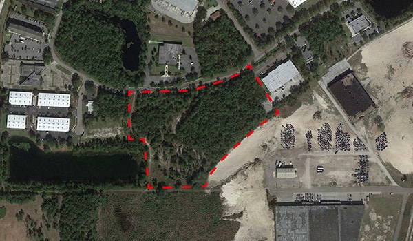
440 Dundas Dr
044279-1500
42-97 49-1S-26E 7 BUSCH DRIVE BUSINESS PARK UNIT 02 PT TRACT J RECD O/R 21119-322 BEING PARCEL 1
Warehouse
DUVAL
IBP
Florida
B and X Area of moderate flood hazard, usually the area between the limits of the 100-year and 500-year floods.
j
2025
6.87 AC
2026
Northeast Jacksonville
010402
Jacksonville (Florida)
110,055 SF
Jacksonville, FL
NEARBY LISTINGS FOR SALE OR LEASE
DEMOGRAPHICS near 440 Dundas Dr
1 mile
3 mile
5 mile
2025 Total Population
4,275
43,583
128,929
2030 Population
4,540
46,283
137,826
Pop Growth 2025-2030
+ 6.20%
+ 6.20%
+ 6.90%
Average Age
37
38
39
2025 Total Households
1,678
16,959
50,222
HH Growth 2025-2030
+ 6.50%
+ 6.51%
+ 7.21%
Median Household Inc
$51,522
$54,787
$52,459
Avg Household Size
2.50
2.50
2.50
2025 Avg HH Vehicles
1.00
2.00
2.00
Median Home Value
$226,035
$223,813
$228,880
Median Year Built
1978
1979
1978
Nearby Places
Map Layers
Map Styles
 Street
 Aerial
Layers
 Traffic
 Biking
Places
Listings with unknown addresses are not visible on the map
- Restaurants
- Banks
- Shops
- Fitness
- Groceries
PUBLIC TRANSPORTATION
COMMUTER RAIL
Jacksonville (Silver Meteor - Amtrak, Silver Star - Amtrak)
Drive
Walk
Distance
Jacksonville (Silver Meteor - Amtrak, Silver Star - Amtrak)
15 min
7.9 mi
AIRPORT
Jacksonville International
Drive
Walk
Distance
Jacksonville International
14 min
7.5 mi
Freight Ports
Jacksonville Port
Drive
Walk
Distance
Jacksonville Port
15 min
6.7 mi
SALE & LEASE HISTORY
LISTING DATE
SALE/LEASE

Mar 07, 2019
For Sale
Nearby Properties
Address
Land Use
TOTAL SIZE
Lot Size
Zoning
Address
Land Use
TOTAL SIZE
Lot Size
Zoning
608,297 SF
49.09 AC
IBP
Address
Land Use
TOTAL SIZE
Lot Size
Zoning
1,064,086 SF
87.81 AC
IL
Address
Land Use
TOTAL SIZE
Lot Size
Zoning
1,010,874 SF
62.96 AC
PUD
Address
Land Use
TOTAL SIZE
Lot Size
Zoning
336,852 SF
32.69 AC
IL
Address
Land Use
TOTAL SIZE
Lot Size
Zoning
1,170,252 SF
201.15 AC
IH
Address
Land Use
TOTAL SIZE
Lot Size
Zoning
823,286 SF
53.36 AC
IL
Address
Land Use
TOTAL SIZE
Lot Size
Zoning
226,596 SF
13.23 AC
PUD
Address
Land Use
TOTAL SIZE
Lot Size
Zoning
1,678,675 SF
73.48 AC
IL
Address
Land Use
TOTAL SIZE
Lot Size
Zoning
403,103 SF
31.05 AC
PUD
Address
Land Use
TOTAL SIZE
Lot Size
Zoning
588,053 SF
33.10 AC
PUD
Address
Land Use
TOTAL SIZE
Lot Size
Zoning
556,862 SF
27.25 AC
IL
Address
Land Use
TOTAL SIZE
Lot Size
Zoning
477,945 SF
31.03 AC
CCG-2
Address
Land Use
TOTAL SIZE
Lot Size
Zoning
740,260 SF
59.11 AC
IL
Address
Land Use
TOTAL SIZE
Lot Size
Zoning
556,016 SF
25.95 AC
IH
Address
Land Use
TOTAL SIZE
Lot Size
Zoning
428,690 SF
29.57 AC
IL
Address
Land Use
TOTAL SIZE
Lot Size
Zoning
321,938 SF
29.46 AC
CCG-1
Address
Land Use
TOTAL SIZE
Lot Size
Zoning
284,023 SF
25.30 AC
RMD-C
Address
Land Use
TOTAL SIZE
Lot Size
Zoning
287,410 SF
43.31 AC
RMD-C
Address
Land Use
TOTAL SIZE
Lot Size
Zoning
214,742 SF
20.13 AC
PUD
Address
Land Use
TOTAL SIZE
Lot Size
Zoning
313,741 SF
37.05 AC
RMD-C
Address
Land Use
TOTAL SIZE
Lot Size
Zoning
478,803 SF
24.43 AC
IL
Address
Land Use
TOTAL SIZE
Lot Size
Zoning
170,638 SF
10.77 AC
PUD
Address
Land Use
TOTAL SIZE
Lot Size
Zoning
398,880 SF
24.63 AC
IL
Address
Land Use
TOTAL SIZE
Lot Size
Zoning
210,520 SF
34.87 AC
PUD
Address
Land Use
TOTAL SIZE
Lot Size
Zoning
303,200 SF
17.47 AC
IL
Address
Land Use
TOTAL SIZE
Lot Size
Zoning
274,834 SF
17.84 AC
IW
Address
Land Use
TOTAL SIZE
Lot Size
Zoning
282,099 SF
14.53 AC
IL
Address
Land Use
TOTAL SIZE
Lot Size
Zoning
283,689 SF
21.28 AC
RLD-60
Address
Land Use
TOTAL SIZE
Lot Size
Zoning
269,278 SF
18.95 AC
IL
Address
Land Use
TOTAL SIZE
Lot Size
Zoning
237,480 SF
19.61 AC
PUD
The World's #1 Commercial Real Estate Marketplace
Connect with us
© 2026 CoStar Group
The information above has been obtained from sources believed reliable. While we do not doubt its accuracy we have not verified it and make no guarantee, warranty or representation about it. It is your responsibility to independently confirm its accuracy and completeness. Any projections, opinions, assumptions, or estimates used are for example only and do not represent the current or future performance of the property. The value of this transaction to you depends on tax and other factors which should be evaluated by your tax, financial, and legal advisors. You and your advisors should conduct a careful, independent investigation of the property to determine to your satisfaction the suitability of the property for your needs.