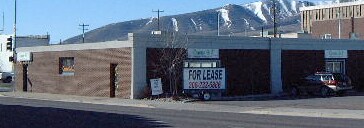
Property Record
440 E Clark St, Pocatello, ID 83201

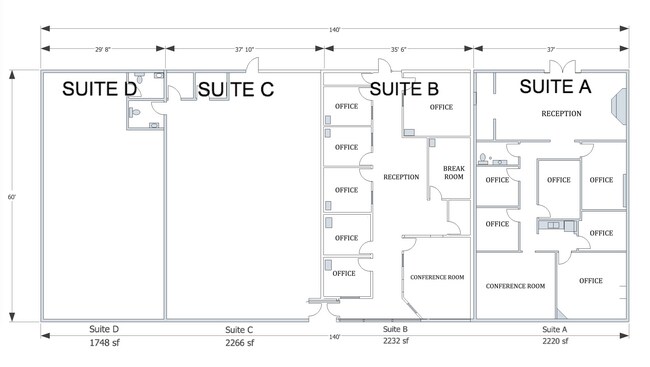
Current Lease Availabilities
Property Detail
440 E Clark St
Pocatello, ID
LOTS 6 THRU 10 BLOC 326 POCATELLO TOWNSITE
RPPOC216801
Bannock
Commercialnec
Idaho
B and X Area of moderate flood hazard, usually the area between the limits of the 100-year and 500-year floods.
6-10
2025
0.48 AC
2025
Idaho South Area
000800
Other Market Areas
NEARBY LISTINGS FOR SALE OR LEASE
DEMOGRAPHICS near 440 E Clark St
1 mile
3 mile
5 mile
2025 Total Population
12,488
46,221
77,366
2030 Population
12,868
47,658
80,092
Pop Growth 2025-2030
+ 3.04%
+ 3.11%
+ 3.52%
Average Age
37
37
37
2025 Total Households
5,622
18,250
29,185
HH Growth 2025-2030
+ 3.29%
+ 3.27%
+ 3.64%
Median Household Inc
$39,933
$58,062
$67,236
Avg Household Size
2.10
2.40
2.50
2025 Avg HH Vehicles
2.00
2.00
2.00
Median Home Value
$267,762
$291,243
$331,599
Median Year Built
1950
1968
1977
Nearby Places
Map Layers
Map Styles
 Street
 Aerial
Transit
 Traffic
 Biking
Places
Listings with unknown addresses are not visible on the map
- Restaurants
- Banks
- Shops
- Fitness
- Groceries
Nearby Properties
Address
Land Use
TOTAL SIZE
Lot Size
Zoning
Address
Land Use
TOTAL SIZE
Lot Size
Zoning
32.29 AC
Address
Land Use
TOTAL SIZE
Lot Size
Zoning
19.02 AC
Address
Land Use
TOTAL SIZE
Lot Size
Zoning
30.05 AC
Address
Land Use
TOTAL SIZE
Lot Size
Zoning
11.42 AC
Address
Land Use
TOTAL SIZE
Lot Size
Zoning
28.61 AC
Address
Land Use
TOTAL SIZE
Lot Size
Zoning
0.53 AC
Address
Land Use
TOTAL SIZE
Lot Size
Zoning
14.20 AC
Address
Land Use
TOTAL SIZE
Lot Size
Zoning
12.59 AC
Address
Land Use
TOTAL SIZE
Lot Size
Zoning
2.08 AC
Address
Land Use
TOTAL SIZE
Lot Size
Zoning
Address
Land Use
TOTAL SIZE
Lot Size
Zoning
3.22 AC
Address
Land Use
TOTAL SIZE
Lot Size
Zoning
12.80 AC
Address
Land Use
TOTAL SIZE
Lot Size
Zoning
12.59 AC
Address
Land Use
TOTAL SIZE
Lot Size
Zoning
4.62 AC
Address
Land Use
TOTAL SIZE
Lot Size
Zoning
2.85 AC
Address
Land Use
TOTAL SIZE
Lot Size
Zoning
Address
Land Use
TOTAL SIZE
Lot Size
Zoning
9.08 AC
Address
Land Use
TOTAL SIZE
Lot Size
Zoning
Address
Land Use
TOTAL SIZE
Lot Size
Zoning
13.12 AC
Address
Land Use
TOTAL SIZE
Lot Size
Zoning
Address
Land Use
TOTAL SIZE
Lot Size
Zoning
Address
Land Use
TOTAL SIZE
Lot Size
Zoning
4.19 AC
Address
Land Use
TOTAL SIZE
Lot Size
Zoning
138.91 AC
Address
Land Use
TOTAL SIZE
Lot Size
Zoning
1.46 AC
Address
Land Use
TOTAL SIZE
Lot Size
Zoning
Address
Land Use
TOTAL SIZE
Lot Size
Zoning
5.63 AC
Address
Land Use
TOTAL SIZE
Lot Size
Zoning
1.64 AC
Address
Land Use
TOTAL SIZE
Lot Size
Zoning
The World's #1 Commercial Real Estate Marketplace
Connect with us
© 2026 CoStar Group
The information above has been obtained from sources believed reliable. While we do not doubt its accuracy we have not verified it and make no guarantee, warranty or representation about it. It is your responsibility to independently confirm its accuracy and completeness. Any projections, opinions, assumptions, or estimates used are for example only and do not represent the current or future performance of the property. The value of this transaction to you depends on tax and other factors which should be evaluated by your tax, financial, and legal advisors. You and your advisors should conduct a careful, independent investigation of the property to determine to your satisfaction the suitability of the property for your needs.