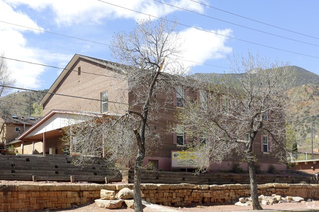
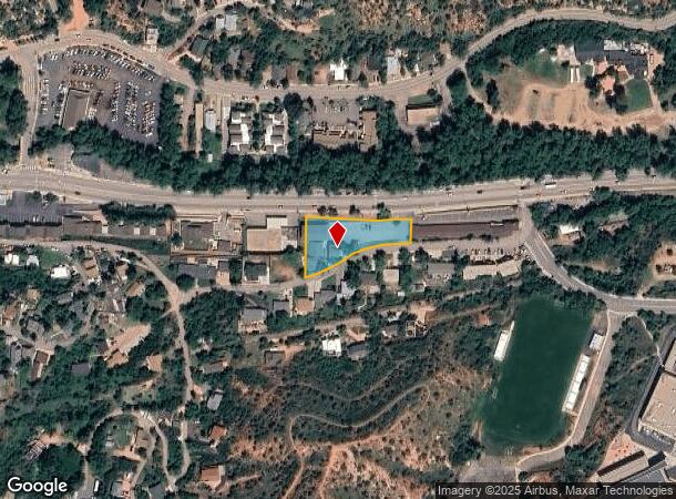
Property Record
440 E Fountain Pl, Manitou Springs, CO 80829

NEARBY LISTINGS FOR SALE OR LEASE
Property Detail
440 E Fountain Pl
Colorado Springs, CO
Manitou Spgs
74054-00-002
LOT 11, E 20 FT OF LOT 10 BLK P MANITOU SPGS ADJ TRACT IN SE4 OF SEC 5-14-67 AS FOLS, BEG AT INTSEC OF NLY EXT OF A LN 20 FT W OF + PARA WITH W LN OF AFSD LOT 11 BLK P WITH SLY LN OF MANITOU AVE, TH ELY ON SLY LN OF MANITOU AVE 298 FT, SLY TO N LN OF
Multifamilydwelling
El Paso
X
Colorado
08041C0706G
11,10
2024
0.69 AC
2025
Southwest
006702
Colorado Springs
10,016 SF
DEMOGRAPHICS near 440 E Fountain Pl
1 Mile
3 Mile
5 Mile
2024 Total Population
4,212
19,838
69,496
2029 Population
4,398
20,779
72,730
Pop Growth 2024-2029
+ 4.42%
+ 4.74%
+ 4.65%
Average Age
45
47
43
2024 Total Households
2,127
9,527
31,841
HH Growth 2024-2029
+ 4.70%
+ 5.10%
+ 4.95%
Median Household Inc
$78,739
$72,899
$68,674
Avg Household Size
2.00
2.00
2.10
2024 Avg HH Vehicles
2.00
2.00
2.00
Median Home Value
$563,444
$469,767
$464,434
Median Year Built
1951
1971
1975
Nearby Places
Map Layers
Map Styles
 Street
 Aerial
- Restaurants
- Banks
- Shops
- Fitness
- Groceries
PUBLIC TRANSPORTATION
AIRPORT
City of Colorado Springs Municipal
DRIVE
WALK
Distance
City of Colorado Springs Municipal
28 min
15.7 mi
Freight Ports
Tulsa Port Of Catoosa
DRIVE
WALK
Distance
Tulsa Port Of Catoosa
752 min
699.7 mi
Nearby Properties
Address
Land Use
TOTAL SIZE
Lot Size
Zoning
Address
Land Use
TOTAL SIZE
Lot Size
Zoning
107,247 SF
56.98 AC
R-E PF
Address
Land Use
TOTAL SIZE
Lot Size
Zoning
2,422 SF
616.19 AC
PK MX-I PD
Address
Land Use
TOTAL SIZE
Lot Size
Zoning
75,349 SF
27.75 AC
EPC
Address
Land Use
TOTAL SIZE
Lot Size
Zoning
45,268 SF
8.37 AC
PDZ UV
Address
Land Use
TOTAL SIZE
Lot Size
Zoning
37,196 SF
3 AC
PDZ
Address
Land Use
TOTAL SIZE
Lot Size
Zoning
4.78 AC
R-T
Address
Land Use
TOTAL SIZE
Lot Size
Zoning
157,471 SF
0.02 AC
PUD,HS
Address
Land Use
TOTAL SIZE
Lot Size
Zoning
17,764 SF
1.63 AC
PDZ
Address
Land Use
TOTAL SIZE
Lot Size
Zoning
20,147 SF
38.98 AC
PK HS
Address
Land Use
TOTAL SIZE
Lot Size
Zoning
127.25 AC
PK HS
Address
Land Use
TOTAL SIZE
Lot Size
Zoning
31,314 SF
1.55 AC
MX-M/CR
Address
Land Use
TOTAL SIZE
Lot Size
Zoning
34,296 SF
0.85 AC
Address
Land Use
TOTAL SIZE
Lot Size
Zoning
3,058 SF
28.22 AC
HLDR
Address
Land Use
TOTAL SIZE
Lot Size
Zoning
6,658 SF
189.56 AC
R-E PK HS
Address
Land Use
TOTAL SIZE
Lot Size
Zoning
14,263 SF
0.98 AC
R-2 R-5
Address
Land Use
TOTAL SIZE
Lot Size
Zoning
80 AC
PK HS SS
Address
Land Use
TOTAL SIZE
Lot Size
Zoning
1,188 SF
27.20 AC
R-E
Address
Land Use
TOTAL SIZE
Lot Size
Zoning
464,447 SF
17.53 AC
PDZ
Address
Land Use
TOTAL SIZE
Lot Size
Zoning
33,548 SF
3.80 AC
R-E
Address
Land Use
TOTAL SIZE
Lot Size
Zoning
31,110 SF
9.38 AC
R-1 6
Address
Land Use
TOTAL SIZE
Lot Size
Zoning
4,062 SF
355.88 AC
PK HS
Address
Land Use
TOTAL SIZE
Lot Size
Zoning
33,673 SF
0.83 AC
MX-M
Address
Land Use
TOTAL SIZE
Lot Size
Zoning
15,964 SF
6.04 AC
R-2 HS CU
Address
Land Use
TOTAL SIZE
Lot Size
Zoning
36,471 SF
3.03 AC
MX-L
Address
Land Use
TOTAL SIZE
Lot Size
Zoning
24,433 SF
1.69 AC
R-1 6
Address
Land Use
TOTAL SIZE
Lot Size
Zoning
16,964 SF
2.43 AC
PF
Address
Land Use
TOTAL SIZE
Lot Size
Zoning
38,885 SF
5.82 AC
R-1 6
Address
Land Use
TOTAL SIZE
Lot Size
Zoning
24,087 SF
1.25 AC
LI CU
Address
Land Use
TOTAL SIZE
Lot Size
Zoning
13,669 SF
0.96 AC
R-2
Address
Land Use
TOTAL SIZE
Lot Size
Zoning
6,899 SF
2.77 AC
R-2 HS CU
The World's #1 Commercial Real Estate Marketplace
Connect with us
© 2025 CoStar Group
The information above has been obtained from sources believed reliable. While we do not doubt its accuracy we have not verified it and make no guarantee, warranty or representation about it. It is your responsibility to independently confirm its accuracy and completeness. Any projections, opinions, assumptions, or estimates used are for example only and do not represent the current or future performance of the property. The value of this transaction to you depends on tax and other factors which should be evaluated by your tax, financial, and legal advisors. You and your advisors should conduct a careful, independent investigation of the property to determine to your satisfaction the suitability of the property for your needs.