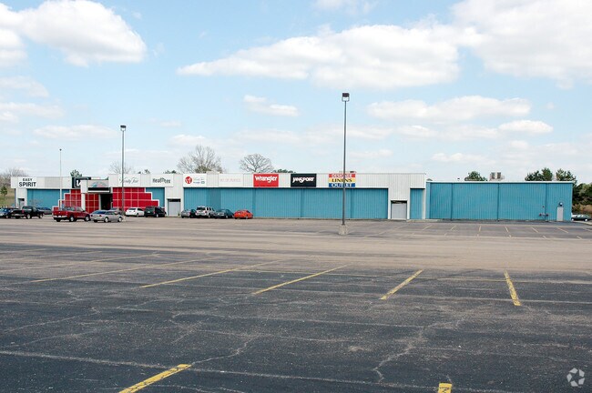
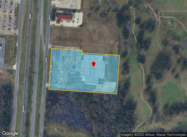
Property Record
440 Highway 59 Loop S, Livingston, TX 77351
NEARBY LISTINGS FOR SALE OR LEASE
Property Detail
440 Highway 59 Loop S
Other Market Areas
Abst 56 Joseph Morgan Survey
10056-0169-50
ABST 56 JOSEPH MORGAN SURVEY TRACT 174-D
Agriculturalland
Polk
X
Texas
48373C0455C
174-d
2025
7.54 AC
2025
Texas East Area
210204
DEMOGRAPHICS near 440 Highway 59 Loop S
1 Mile
3 Mile
5 Mile
2024 Total Population
1,395
9,245
19,404
2029 Population
1,629
10,924
22,533
Pop Growth 2024-2029
+ 16.77%
+ 18.16%
+ 16.13%
Average Age
39
40
42
2024 Total Households
574
3,378
5,976
HH Growth 2024-2029
+ 15.85%
+ 17.47%
+ 17.49%
Median Household Inc
$46,221
$43,945
$46,419
Avg Household Size
2.40
2.50
2.50
2024 Avg HH Vehicles
2.00
2.00
2.00
Median Home Value
$97,058
$124,625
$141,820
Median Year Built
1980
1984
1987
Nearby Places
Map Layers
Map Styles
 Street
 Aerial
- Restaurants
- Banks
- Shops
- Fitness
- Groceries
Nearby Properties
Address
Land Use
TOTAL SIZE
Lot Size
Zoning
Address
Land Use
TOTAL SIZE
Lot Size
Zoning
Address
Land Use
TOTAL SIZE
Lot Size
Zoning
69,127 SF
24.67 AC
Address
Land Use
TOTAL SIZE
Lot Size
Zoning
70,339 SF
15.26 AC
Address
Land Use
TOTAL SIZE
Lot Size
Zoning
183,134 SF
18.41 AC
Address
Land Use
TOTAL SIZE
Lot Size
Zoning
Address
Land Use
TOTAL SIZE
Lot Size
Zoning
22,864 SF
5.11 AC
Address
Land Use
TOTAL SIZE
Lot Size
Zoning
64,757 SF
54.91 AC
Address
Land Use
TOTAL SIZE
Lot Size
Zoning
111,072 SF
11.14 AC
Address
Land Use
TOTAL SIZE
Lot Size
Zoning
2,412 SF
224.20 AC
Address
Land Use
TOTAL SIZE
Lot Size
Zoning
51,080 SF
16.41 AC
Address
Land Use
TOTAL SIZE
Lot Size
Zoning
33,724 SF
10.86 AC
Address
Land Use
TOTAL SIZE
Lot Size
Zoning
6,006 SF
1.18 AC
Address
Land Use
TOTAL SIZE
Lot Size
Zoning
37,532 SF
5.19 AC
Address
Land Use
TOTAL SIZE
Lot Size
Zoning
45,188 SF
5.04 AC
Address
Land Use
TOTAL SIZE
Lot Size
Zoning
13.92 AC
Address
Land Use
TOTAL SIZE
Lot Size
Zoning
17,565 SF
8 AC
Address
Land Use
TOTAL SIZE
Lot Size
Zoning
32,901 SF
1.31 AC
Address
Land Use
TOTAL SIZE
Lot Size
Zoning
41,424 SF
10.55 AC
Address
Land Use
TOTAL SIZE
Lot Size
Zoning
7,552 SF
4 AC
Address
Land Use
TOTAL SIZE
Lot Size
Zoning
18,899 SF
13.49 AC
Address
Land Use
TOTAL SIZE
Lot Size
Zoning
10,514 SF
3.50 AC
Address
Land Use
TOTAL SIZE
Lot Size
Zoning
35,292 SF
1.69 AC
Address
Land Use
TOTAL SIZE
Lot Size
Zoning
24,360 SF
3.79 AC
Address
Land Use
TOTAL SIZE
Lot Size
Zoning
10,187 SF
6.06 AC
Address
Land Use
TOTAL SIZE
Lot Size
Zoning
20,340 SF
1.96 AC
Address
Land Use
TOTAL SIZE
Lot Size
Zoning
16,241 SF
2.68 AC
Address
Land Use
TOTAL SIZE
Lot Size
Zoning
7.12 AC
Address
Land Use
TOTAL SIZE
Lot Size
Zoning
28,896 SF
4.86 AC
Address
Land Use
TOTAL SIZE
Lot Size
Zoning
31,463 SF
4 AC
Address
Land Use
TOTAL SIZE
Lot Size
Zoning
27,369 SF
0.46 AC
The World's #1 Commercial Real Estate Marketplace
Connect with us
© 2026 CoStar Group
The information above has been obtained from sources believed reliable. While we do not doubt its accuracy we have not verified it and make no guarantee, warranty or representation about it. It is your responsibility to independently confirm its accuracy and completeness. Any projections, opinions, assumptions, or estimates used are for example only and do not represent the current or future performance of the property. The value of this transaction to you depends on tax and other factors which should be evaluated by your tax, financial, and legal advisors. You and your advisors should conduct a careful, independent investigation of the property to determine to your satisfaction the suitability of the property for your needs.