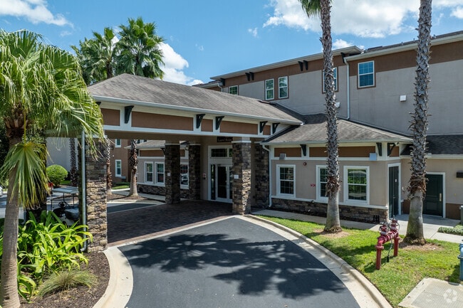
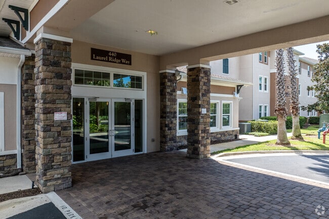
Property Record
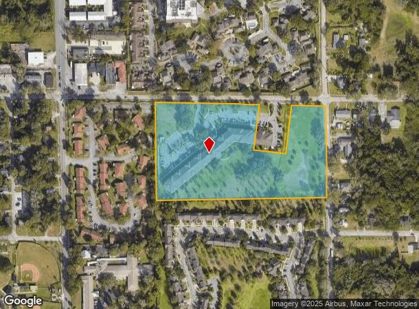
440 Laurel Ridge Way, Deland, FL 32724
NEARBY LISTINGS FOR SALE OR LEASE
Property Detail
440 Laurel Ridge Way
Deltona-Daytona Beach-Ormond Beach, FL
Laurel Communities Subdivision Mb
7016-59-00-0020
16 17 30 LOT B LAUREL COMMUNITIES SUBDIVISION MB 56 PG 93
Municipalproperty
Volusia
X
Florida
12127C0470H
b
0
0.65 AC
2025
Outer Deland/Deltona
090600
Deltona/Daytona Beach
97,752 SF
DEMOGRAPHICS near 440 Laurel Ridge Way
1 Mile
3 Mile
5 Mile
2024 Total Population
10,285
48,851
79,881
2029 Population
11,346
54,079
88,525
Pop Growth 2024-2029
+ 10.32%
+ 10.70%
+ 10.82%
Average Age
39
41
42
2024 Total Households
3,793
18,651
30,938
HH Growth 2024-2029
+ 10.52%
+ 10.90%
+ 10.99%
Median Household Inc
$33,758
$58,929
$63,095
Avg Household Size
2.20
2.40
2.40
2024 Avg HH Vehicles
1.00
2.00
2.00
Median Home Value
$199,812
$246,418
$248,645
Median Year Built
1975
1984
1987
Nearby Places
- Restaurants
- Banks
- Shops
- Fitness
- Groceries
PUBLIC TRANSPORTATION
COMMUTER RAIL
Deland (Silver Meteor - Amtrak, Silver Star - Amtrak, SunRail - Amtrak)
DRIVE
WALK
Distance
Deland (Silver Meteor - Amtrak, Silver Star - Amtrak, SunRail - Amtrak)
9 min
4.0 mi
AIRPORT
Daytona Beach International
DRIVE
WALK
Distance
Daytona Beach International
29 min
19.7 mi
Orlando Sanford International
DRIVE
WALK
Distance
Orlando Sanford International
41 min
26.0 mi
Freight Ports
Port Canaveral
DRIVE
WALK
Distance
Port Canaveral
93 min
76.7 mi
Nearby Properties
Address
Land Use
TOTAL SIZE
Lot Size
Zoning
Address
Land Use
TOTAL SIZE
Lot Size
Zoning
429,125 SF
8.24 AC
05C2
Address
Land Use
TOTAL SIZE
Lot Size
Zoning
493,551 SF
51.22 AC
05R4
Address
Land Use
TOTAL SIZE
Lot Size
Zoning
272,160 SF
21.70 AC
Address
Land Use
TOTAL SIZE
Lot Size
Zoning
292,755 SF
37.36 AC
01B1
Address
Land Use
TOTAL SIZE
Lot Size
Zoning
260,469 SF
9.97 AC
Address
Land Use
TOTAL SIZE
Lot Size
Zoning
167,670 SF
1.44 AC
05C2
Address
Land Use
TOTAL SIZE
Lot Size
Zoning
241,240 SF
8.27 AC
05R1B
Address
Land Use
TOTAL SIZE
Lot Size
Zoning
242,839 SF
14.42 AC
05R4
Address
Land Use
TOTAL SIZE
Lot Size
Zoning
206,426 SF
4.10 AC
05C2
Address
Land Use
TOTAL SIZE
Lot Size
Zoning
101,732 SF
25.47 AC
P
Address
Land Use
TOTAL SIZE
Lot Size
Zoning
312,508 SF
28.68 AC
05C2
Address
Land Use
TOTAL SIZE
Lot Size
Zoning
238,812 SF
0.69 AC
05R12
Address
Land Use
TOTAL SIZE
Lot Size
Zoning
159,789 SF
18.31 AC
05R4
Address
Land Use
TOTAL SIZE
Lot Size
Zoning
231,640 SF
25 AC
Address
Land Use
TOTAL SIZE
Lot Size
Zoning
130,551 SF
7.28 AC
Address
Land Use
TOTAL SIZE
Lot Size
Zoning
134,961 SF
19.98 AC
P
Address
Land Use
TOTAL SIZE
Lot Size
Zoning
299,124 SF
14.94 AC
Address
Land Use
TOTAL SIZE
Lot Size
Zoning
106,525 SF
22.21 AC
A3
Address
Land Use
TOTAL SIZE
Lot Size
Zoning
101,851 SF
17.98 AC
05R1AA
Address
Land Use
TOTAL SIZE
Lot Size
Zoning
221,179 SF
23.98 AC
Address
Land Use
TOTAL SIZE
Lot Size
Zoning
129,133 SF
2.01 AC
05C2
Address
Land Use
TOTAL SIZE
Lot Size
Zoning
288,482 SF
26.14 AC
Address
Land Use
TOTAL SIZE
Lot Size
Zoning
388,366 SF
47.70 AC
Address
Land Use
TOTAL SIZE
Lot Size
Zoning
115,145 SF
29.26 AC
A3
Address
Land Use
TOTAL SIZE
Lot Size
Zoning
68,913 SF
7.98 AC
Address
Land Use
TOTAL SIZE
Lot Size
Zoning
70,209 SF
1.68 AC
05C2
Address
Land Use
TOTAL SIZE
Lot Size
Zoning
77,738 SF
9.20 AC
Address
Land Use
TOTAL SIZE
Lot Size
Zoning
8,078 SF
2.16 AC
R4
Address
Land Use
TOTAL SIZE
Lot Size
Zoning
264,819 SF
10 AC
05R4
Address
Land Use
TOTAL SIZE
Lot Size
Zoning
89,521 SF
12.40 AC
The World's #1 Commercial Real Estate Marketplace
Connect with us
© 2025 CoStar Group
The information above has been obtained from sources believed reliable. While we do not doubt its accuracy we have not verified it and make no guarantee, warranty or representation about it. It is your responsibility to independently confirm its accuracy and completeness. Any projections, opinions, assumptions, or estimates used are for example only and do not represent the current or future performance of the property. The value of this transaction to you depends on tax and other factors which should be evaluated by your tax, financial, and legal advisors. You and your advisors should conduct a careful, independent investigation of the property to determine to your satisfaction the suitability of the property for your needs.