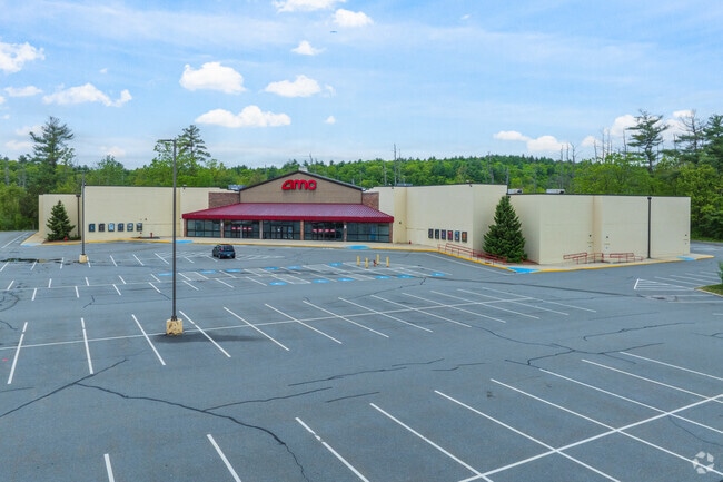
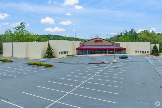
Property Record
440 Middlesex Rd, Tyngsboro, MA 01879

Property Detail
440 Middlesex Rd
TYNG-000011-000005-000002
Middlesex
Theater
Massachusetts
B3
2
A Areas with a 1% annual chance of flooding and a 26% chance of flooding over the life of a 30-year mortgage.
8.74 AC
2025
Groton/Townsend
2025
Boston
313101
Boston-Cambridge-Newton, MA-NH
39,464 SF
NEARBY LISTINGS FOR SALE OR LEASE
DEMOGRAPHICS near 440 Middlesex Rd
1 mile
3 mile
5 mile
2025 Total Population
4,233
31,471
110,869
2030 Population
4,296
32,031
113,146
Pop Growth 2025-2030
+ 1.49%
+ 1.78%
+ 2.05%
Average Age
37
42
42
2025 Total Households
2,143
12,866
44,091
HH Growth 2025-2030
+ 1.54%
+ 1.81%
+ 2.06%
Median Household Inc
$84,953
$115,703
$104,899
Avg Household Size
2.00
2.40
2.40
2025 Avg HH Vehicles
1.00
2.00
2.00
Median Home Value
$229,592
$493,137
$461,219
Median Year Built
1982
1983
1978
Nearby Places
Map Layers
Map Styles
 Street
 Aerial
Layers
 Traffic
 Biking
Places
Listings with unknown addresses are not visible on the map
- Restaurants
- Banks
- Shops
- Fitness
- Groceries
PUBLIC TRANSPORTATION
COMMUTER RAIL
Lowell (Lowell Line - Massachusetts Bay Transportation Authority Commuter Rail (Purple Line))
Drive
Walk
Distance
Lowell (Lowell Line - Massachusetts Bay Transportation Authority Commuter Rail (Purple Line))
18 min
9.4 mi
AIRPORT
Manchester Boston Regional
Drive
Walk
Distance
Manchester Boston Regional
32 min
20.6 mi
Freight Ports
Port of Boston
Drive
Walk
Distance
Port of Boston
61 min
43.9 mi
SALE & LEASE HISTORY
LISTING DATE
SALE/LEASE

Oct 21, 2019
For Sale
Mar 21, 2022
For Sale
Nearby Properties
Address
Land Use
TOTAL SIZE
Lot Size
Zoning
Address
Land Use
TOTAL SIZE
Lot Size
Zoning
38.17 AC
RC
Address
Land Use
TOTAL SIZE
Lot Size
Zoning
29.77 AC
RC
Address
Land Use
TOTAL SIZE
Lot Size
Zoning
80.11 AC
PI
Address
Land Use
TOTAL SIZE
Lot Size
Zoning
20.72 AC
RC
Address
Land Use
TOTAL SIZE
Lot Size
Zoning
15.19 AC
RC
Address
Land Use
TOTAL SIZE
Lot Size
Zoning
118.50 AC
PI
Address
Land Use
TOTAL SIZE
Lot Size
Zoning
20.80 AC
RC
Address
Land Use
TOTAL SIZE
Lot Size
Zoning
303,508 SF
171.19 AC
G1
Address
Land Use
TOTAL SIZE
Lot Size
Zoning
52.45 AC
R18
Address
Land Use
TOTAL SIZE
Lot Size
Zoning
206,913 SF
18.30 AC
GB
Address
Land Use
TOTAL SIZE
Lot Size
Zoning
15.16 AC
GI
Address
Land Use
TOTAL SIZE
Lot Size
Zoning
21.40 AC
RC
Address
Land Use
TOTAL SIZE
Lot Size
Zoning
37.57 AC
R9
Address
Land Use
TOTAL SIZE
Lot Size
Zoning
153,922 SF
6.84 AC
GB
Address
Land Use
TOTAL SIZE
Lot Size
Zoning
312,738 SF
25.84 AC
ID
Address
Land Use
TOTAL SIZE
Lot Size
Zoning
127,494 SF
9.09 AC
GB
Address
Land Use
TOTAL SIZE
Lot Size
Zoning
12.55 AC
RC
Address
Land Use
TOTAL SIZE
Lot Size
Zoning
199.97 AC
B2
Address
Land Use
TOTAL SIZE
Lot Size
Zoning
21.17 AC
RC
Address
Land Use
TOTAL SIZE
Lot Size
Zoning
8.09 AC
RC
Address
Land Use
TOTAL SIZE
Lot Size
Zoning
154,620 SF
8.63 AC
GB
Address
Land Use
TOTAL SIZE
Lot Size
Zoning
116,602 SF
11.74 AC
GB
Address
Land Use
TOTAL SIZE
Lot Size
Zoning
12.57 AC
RC
Address
Land Use
TOTAL SIZE
Lot Size
Zoning
233,668 SF
16.83 AC
PI
Address
Land Use
TOTAL SIZE
Lot Size
Zoning
144,018 SF
13.89 AC
PI
Address
Land Use
TOTAL SIZE
Lot Size
Zoning
45.10 AC
R1
Address
Land Use
TOTAL SIZE
Lot Size
Zoning
161,790 SF
9 AC
PI
Address
Land Use
TOTAL SIZE
Lot Size
Zoning
8.30 AC
B3
Address
Land Use
TOTAL SIZE
Lot Size
Zoning
135,324 SF
70.07 AC
R1
The World's #1 Commercial Real Estate Marketplace
Connect with us
© 2026 CoStar Group
The information above has been obtained from sources believed reliable. While we do not doubt its accuracy we have not verified it and make no guarantee, warranty or representation about it. It is your responsibility to independently confirm its accuracy and completeness. Any projections, opinions, assumptions, or estimates used are for example only and do not represent the current or future performance of the property. The value of this transaction to you depends on tax and other factors which should be evaluated by your tax, financial, and legal advisors. You and your advisors should conduct a careful, independent investigation of the property to determine to your satisfaction the suitability of the property for your needs.