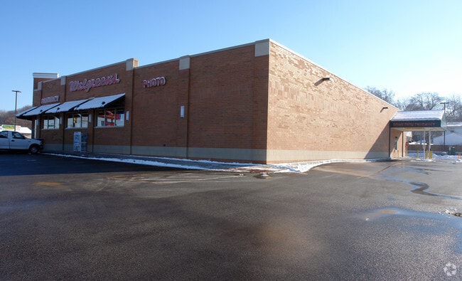
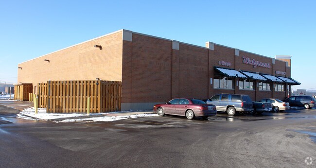
Property Record
440 W 10Th Ave W, Milan, IL 61264

NEARBY LISTINGS FOR SALE OR LEASE
-
-
-
-
No Photo
-
View all Milan listings for sale on LoopNet.com
Property Detail
440 W 10Th Ave W
Davenport/Moline/Rock Island
Origin 1St Add
Davenport-Moline-Rock Island, IA-IL
LOT 1 EXCEPT NE PART TO IDOT IN ORIGIN 1ST ADDITION. SHEET 39
16-26-221-003
Rock Island
Commercialnec
Illinois
2024
1
2024
1.64 AC
024200
Outlying Rock Island Cnty
DEMOGRAPHICS near 440 W 10Th Ave W
1 Mile
3 Mile
5 Mile
2024 Total Population
4,002
18,942
65,393
2029 Population
3,895
18,492
63,993
Pop Growth 2024-2029
(2.67%)
(2.38%)
(2.14%)
Average Age
43
43
41
2024 Total Households
1,924
8,472
27,395
HH Growth 2024-2029
(2.70%)
(2.41%)
(2.27%)
Median Household Inc
$52,408
$57,499
$54,519
Avg Household Size
2.00
2.20
2.20
2024 Avg HH Vehicles
2.00
2.00
2.00
Median Home Value
$113,178
$146,739
$122,123
Median Year Built
1964
1963
1953
Nearby Places
Map Layers
Map Styles
 Street
 Aerial
- Restaurants
- Banks
- Shops
- Fitness
- Groceries
PUBLIC TRANSPORTATION
AIRPORT
Quad Cities International
DRIVE
WALK
Distance
Quad Cities International
13 min
5.7 mi
Nearby Properties
Address
Land Use
TOTAL SIZE
Lot Size
Zoning
Address
Land Use
TOTAL SIZE
Lot Size
Zoning
227,249 SF
38.78 AC
RI
Address
Land Use
TOTAL SIZE
Lot Size
Zoning
2,595,576 SF
185.35 AC
MIL
Address
Land Use
TOTAL SIZE
Lot Size
Zoning
7.86 AC
Address
Land Use
TOTAL SIZE
Lot Size
Zoning
171,322 SF
19.89 AC
RI
Address
Land Use
TOTAL SIZE
Lot Size
Zoning
20.35 AC
MIL
Address
Land Use
TOTAL SIZE
Lot Size
Zoning
47,060 SF
3.23 AC
MOL
Address
Land Use
TOTAL SIZE
Lot Size
Zoning
935,332 SF
41.69 AC
MIL
Address
Land Use
TOTAL SIZE
Lot Size
Zoning
1,800 SF
10 AC
RI
Address
Land Use
TOTAL SIZE
Lot Size
Zoning
14.01 AC
Address
Land Use
TOTAL SIZE
Lot Size
Zoning
79,785 SF
5.61 AC
MIL
Address
Land Use
TOTAL SIZE
Lot Size
Zoning
33.09 AC
Address
Land Use
TOTAL SIZE
Lot Size
Zoning
231,974 SF
7.64 AC
RI
Address
Land Use
TOTAL SIZE
Lot Size
Zoning
24,985 SF
3.36 AC
RI
Address
Land Use
TOTAL SIZE
Lot Size
Zoning
248,417 SF
10.63 AC
RI
Address
Land Use
TOTAL SIZE
Lot Size
Zoning
126,580 SF
10.71 AC
RI
Address
Land Use
TOTAL SIZE
Lot Size
Zoning
7.02 AC
MIL
Address
Land Use
TOTAL SIZE
Lot Size
Zoning
110,400 SF
2.35 AC
RI
Address
Land Use
TOTAL SIZE
Lot Size
Zoning
198,300 SF
12.45 AC
RI
Address
Land Use
TOTAL SIZE
Lot Size
Zoning
170,666 SF
4.79 AC
MIL
Address
Land Use
TOTAL SIZE
Lot Size
Zoning
62,229 SF
6.94 AC
MIL
Address
Land Use
TOTAL SIZE
Lot Size
Zoning
32,445 SF
42 AC
I1
Address
Land Use
TOTAL SIZE
Lot Size
Zoning
81,396 SF
30.77 AC
RI
Address
Land Use
TOTAL SIZE
Lot Size
Zoning
9.76 AC
RI
Address
Land Use
TOTAL SIZE
Lot Size
Zoning
90,528 SF
5.42 AC
MIL
Address
Land Use
TOTAL SIZE
Lot Size
Zoning
70,656 SF
11 AC
RI
Address
Land Use
TOTAL SIZE
Lot Size
Zoning
39,858 SF
9.55 AC
RI
Address
Land Use
TOTAL SIZE
Lot Size
Zoning
12.97 AC
Address
Land Use
TOTAL SIZE
Lot Size
Zoning
120,000 SF
5.42 AC
RI
Address
Land Use
TOTAL SIZE
Lot Size
Zoning
113,600 SF
7.91 AC
I2
Address
Land Use
TOTAL SIZE
Lot Size
Zoning
6,656 SF
30.95 AC
MIL
The World's #1 Commercial Real Estate Marketplace
Connect with us
© 2025 CoStar Group
The information above has been obtained from sources believed reliable. While we do not doubt its accuracy we have not verified it and make no guarantee, warranty or representation about it. It is your responsibility to independently confirm its accuracy and completeness. Any projections, opinions, assumptions, or estimates used are for example only and do not represent the current or future performance of the property. The value of this transaction to you depends on tax and other factors which should be evaluated by your tax, financial, and legal advisors. You and your advisors should conduct a careful, independent investigation of the property to determine to your satisfaction the suitability of the property for your needs.