Property Record
440 W Pennwood St, Meridian, ID 83642
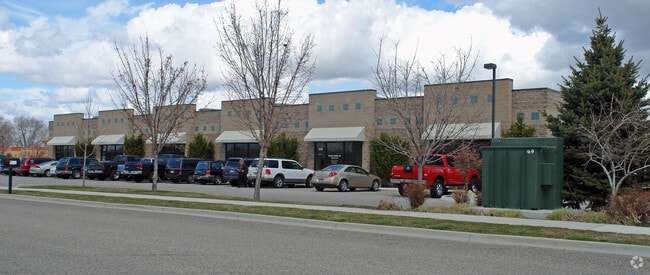


Property Detail
440 W Pennwood St
R8533752200
LOT 09 BLK 02 TROUTNER PARK SUB
Commercialbuilding
Ada
C-G
Idaho
B and X Area of moderate flood hazard, usually the area between the limits of the 100-year and 500-year floods.
09
2024
0.93 AC
2025
Meridian
010348
Boise City/Nampa
9,185 SF
Boise City, ID
NEARBY LISTINGS FOR SALE OR LEASE
DEMOGRAPHICS near 440 W Pennwood St
1 mile
3 mile
5 mile
2025 Total Population
8,595
84,612
196,262
2030 Population
8,950
89,046
206,641
Pop Growth 2025-2030
+ 4.13%
+ 5.24%
+ 5.29%
Average Age
38
39
39
2025 Total Households
3,363
31,177
69,854
HH Growth 2025-2030
+ 4.61%
+ 5.72%
+ 5.72%
Median Household Inc
$70,184
$94,905
$100,405
Avg Household Size
2.50
2.70
2.80
2025 Avg HH Vehicles
2.00
2.00
2.00
Median Home Value
$441,009
$492,766
$526,337
Median Year Built
1994
2002
2003
Nearby Places
Map Layers
Map Styles
 Street
 Aerial
Layers
 Traffic
 Biking
Places
Listings with unknown addresses are not visible on the map
- Restaurants
- Banks
- Shops
- Fitness
- Groceries
PUBLIC TRANSPORTATION
AIRPORT
Boise Air Trml/Gowen Field
Drive
Walk
Distance
Boise Air Trml/Gowen Field
20 min
11.6 mi
SALE & LEASE HISTORY
LISTING DATE
SALE/LEASE

Oct 26, 2017
For Lease
Nearby Properties
Address
Land Use
TOTAL SIZE
Lot Size
Zoning
Address
Land Use
TOTAL SIZE
Lot Size
Zoning
533,727 SF
22.89 AC
C-G
Address
Land Use
TOTAL SIZE
Lot Size
Zoning
319,968 SF
19.50 AC
TN-C
Address
Land Use
TOTAL SIZE
Lot Size
Zoning
263,964 SF
16.29 AC
C-G
Address
Land Use
TOTAL SIZE
Lot Size
Zoning
505,966 SF
51.08 AC
L-O
Address
Land Use
TOTAL SIZE
Lot Size
Zoning
245,810 SF
11.19 AC
R-40
Address
Land Use
TOTAL SIZE
Lot Size
Zoning
269,509 SF
12 AC
R-40
Address
Land Use
TOTAL SIZE
Lot Size
Zoning
309,845 SF
14.53 AC
R-15
Address
Land Use
TOTAL SIZE
Lot Size
Zoning
413,805 SF
15.64 AC
C-G
Address
Land Use
TOTAL SIZE
Lot Size
Zoning
268,802 SF
8.35 AC
R-40
Address
Land Use
TOTAL SIZE
Lot Size
Zoning
335,459 SF
11.23 AC
R-40
Address
Land Use
TOTAL SIZE
Lot Size
Zoning
12.44 AC
R-15
Address
Land Use
TOTAL SIZE
Lot Size
Zoning
243,949 SF
13.81 AC
R-40
Address
Land Use
TOTAL SIZE
Lot Size
Zoning
239,584 SF
7.83 AC
C-G
Address
Land Use
TOTAL SIZE
Lot Size
Zoning
161,870 SF
8.48 AC
C-G
Address
Land Use
TOTAL SIZE
Lot Size
Zoning
305,889 SF
9.91 AC
R-40
Address
Land Use
TOTAL SIZE
Lot Size
Zoning
310,580 SF
2.44 AC
C-G
Address
Land Use
TOTAL SIZE
Lot Size
Zoning
171,454 SF
10.66 AC
C-G
Address
Land Use
TOTAL SIZE
Lot Size
Zoning
203,377 SF
21.13 AC
C-G
Address
Land Use
TOTAL SIZE
Lot Size
Zoning
230,810 SF
20.09 AC
C-G
Address
Land Use
TOTAL SIZE
Lot Size
Zoning
150,000 SF
5.44 AC
C-G
Address
Land Use
TOTAL SIZE
Lot Size
Zoning
200,636 SF
8.95 AC
C-G
Address
Land Use
TOTAL SIZE
Lot Size
Zoning
144,918 SF
4.95 AC
C-G
Address
Land Use
TOTAL SIZE
Lot Size
Zoning
141,360 SF
30.32 AC
I-L
Address
Land Use
TOTAL SIZE
Lot Size
Zoning
147,239 SF
7.56 AC
C-G
Address
Land Use
TOTAL SIZE
Lot Size
Zoning
10.44 AC
R-15
Address
Land Use
TOTAL SIZE
Lot Size
Zoning
238,300 SF
34.70 AC
I-L
Address
Land Use
TOTAL SIZE
Lot Size
Zoning
167,416 SF
18.57 AC
C-G
Address
Land Use
TOTAL SIZE
Lot Size
Zoning
125,362 SF
7.08 AC
C-G
Address
Land Use
TOTAL SIZE
Lot Size
Zoning
176,788 SF
16.07 AC
C-G
Address
Land Use
TOTAL SIZE
Lot Size
Zoning
127,560 SF
4.29 AC
C-G
The World's #1 Commercial Real Estate Marketplace
Connect with us
© 2026 CoStar Group
The information above has been obtained from sources believed reliable. While we do not doubt its accuracy we have not verified it and make no guarantee, warranty or representation about it. It is your responsibility to independently confirm its accuracy and completeness. Any projections, opinions, assumptions, or estimates used are for example only and do not represent the current or future performance of the property. The value of this transaction to you depends on tax and other factors which should be evaluated by your tax, financial, and legal advisors. You and your advisors should conduct a careful, independent investigation of the property to determine to your satisfaction the suitability of the property for your needs.