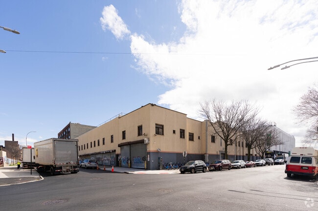
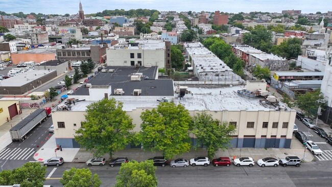
Property Record
4401 2Nd Ave, Brooklyn, NY 11232


NEARBY LISTINGS FOR SALE OR LEASE
Property Detail
4401 2Nd Ave
00736-0001
Kings
Industrialgeneral
New York
X
11
3604970194F
0.46 AC
2024
South Brooklyn
2025
Long Island (New York)
000200
New York-Jersey City-White Plains, NY-NJ
25,500 SF
DEMOGRAPHICS near 4401 2Nd Ave
1 Mile
3 Mile
5 Mile
2024 Total Population
75,969
690,977
2,030,529
2029 Population
68,040
642,929
1,911,698
Pop Growth 2024-2029
(10.44%)
(6.95%)
(5.85%)
Average Age
37
38
38
2024 Total Households
22,088
248,310
760,526
HH Growth 2024-2029
(11.06%)
(7.11%)
(6.08%)
Median Household Inc
$59,553
$81,632
$76,456
Avg Household Size
3.20
2.70
2.50
2024 Avg HH Vehicles
.00
1.00
1.00
Median Home Value
$945,321
$1,021,295
$884,429
Median Year Built
1946
1947
1948
Nearby Places
Map Layers
Map Styles
 Street
 Aerial
- Restaurants
- Banks
- Shops
- Fitness
- Groceries
PUBLIC TRANSPORTATION
TRANSIT/SUBWAY
45 Street (N - New York MTA Subway (The Subway), R - New York MTA Subway (The Subway))
DRIVE
WALK
Distance
45 Street (N - New York MTA Subway (The Subway), R - New York MTA Subway (The Subway))
2 min
6 min
0.3 mi
36 Street (D,M,N,R Line) (D - New York MTA Subway (The Subway), M - New York MTA Subway (The Subway), N - New York MTA Subway (The Subway), R - New York MTA Subway (The Subway))
DRIVE
WALK
Distance
36 Street (D,M,N,R Line) (D - New York MTA Subway (The Subway), M - New York MTA Subway (The Subway), N - New York MTA Subway (The Subway), R - New York MTA Subway (The Subway))
2 min
14 min
0.7 mi
53 Street (N - New York MTA Subway (The Subway), R - New York MTA Subway (The Subway))
DRIVE
WALK
Distance
53 Street (N - New York MTA Subway (The Subway), R - New York MTA Subway (The Subway))
3 min
14 min
0.7 mi
59 Street (N,R Line) (N - New York MTA Subway (The Subway), R - New York MTA Subway (The Subway))
DRIVE
WALK
Distance
59 Street (N,R Line) (N - New York MTA Subway (The Subway), R - New York MTA Subway (The Subway))
4 min
20 min
1.0 mi
COMMUTER RAIL
DRIVE
WALK
Distance
10 min
3.6 mi
Clifton (Staten Island Railway - New York MTA Subway (The Subway))
DRIVE
WALK
Distance
Clifton (Staten Island Railway - New York MTA Subway (The Subway))
14 min
7.3 mi
AIRPORT
LaGuardia
DRIVE
WALK
Distance
LaGuardia
27 min
14.1 mi
John F Kennedy International
DRIVE
WALK
Distance
John F Kennedy International
28 min
15.0 mi
Newark Liberty International
DRIVE
WALK
Distance
Newark Liberty International
31 min
17.7 mi
Freight Ports
NY - Red Hook Container Terminal
DRIVE
WALK
Distance
NY - Red Hook Container Terminal
7 min
3.0 mi
SALE & LEASE HISTORY
LISTING DATE
SALE/LEASE

Oct 29, 2019
For Lease
May 03, 2023
For Sale
Nearby Properties
Address
Land Use
TOTAL SIZE
Lot Size
Zoning
Address
Land Use
TOTAL SIZE
Lot Size
Zoning
92,440 SF
466.23 AC
R5
Address
Land Use
TOTAL SIZE
Lot Size
Zoning
2,542,066 SF
174.49 AC
R3-2
Address
Land Use
TOTAL SIZE
Lot Size
Zoning
393.54 AC
PARK
Address
Land Use
TOTAL SIZE
Lot Size
Zoning
577,381 SF
3.19 AC
R6
Address
Land Use
TOTAL SIZE
Lot Size
Zoning
902,000 SF
6.44 AC
M3-1
Address
Land Use
TOTAL SIZE
Lot Size
Zoning
965,600 SF
6.65 AC
R5
Address
Land Use
TOTAL SIZE
Lot Size
Zoning
460,000 SF
3.21 AC
R6
Address
Land Use
TOTAL SIZE
Lot Size
Zoning
627,018 SF
1.21 AC
C6-4
Address
Land Use
TOTAL SIZE
Lot Size
Zoning
335,800 SF
1.51 AC
R6
Address
Land Use
TOTAL SIZE
Lot Size
Zoning
1,324,592 SF
5.13 AC
M3-1
Address
Land Use
TOTAL SIZE
Lot Size
Zoning
397,354 SF
0.61 AC
C5-2
Address
Land Use
TOTAL SIZE
Lot Size
Zoning
566,000 SF
12.33 AC
R6
Address
Land Use
TOTAL SIZE
Lot Size
Zoning
389,125 SF
3.48 AC
C6-4
Address
Land Use
TOTAL SIZE
Lot Size
Zoning
489,344 SF
3.78 AC
C6-4
Address
Land Use
TOTAL SIZE
Lot Size
Zoning
427,208 SF
1.30 AC
R6
Address
Land Use
TOTAL SIZE
Lot Size
Zoning
258,000 SF
1.86 AC
R6
Address
Land Use
TOTAL SIZE
Lot Size
Zoning
500,000 SF
1.39 AC
C62A
Address
Land Use
TOTAL SIZE
Lot Size
Zoning
393,092 SF
1.07 AC
R8A
Address
Land Use
TOTAL SIZE
Lot Size
Zoning
371,139 SF
3.22 AC
R5
Address
Land Use
TOTAL SIZE
Lot Size
Zoning
5,359,400 SF
59.07 AC
M2-1
Address
Land Use
TOTAL SIZE
Lot Size
Zoning
286,000 SF
12.63 AC
PARK
Address
Land Use
TOTAL SIZE
Lot Size
Zoning
1,785,288 SF
22.38 AC
M2-1
Address
Land Use
TOTAL SIZE
Lot Size
Zoning
3,970,000 SF
91.14 AC
M3-1
Address
Land Use
TOTAL SIZE
Lot Size
Zoning
517,033 SF
0.92 AC
C6-4
Address
Land Use
TOTAL SIZE
Lot Size
Zoning
1,466,751 SF
24.79 AC
R5
Address
Land Use
TOTAL SIZE
Lot Size
Zoning
689,850 SF
3.08 AC
M3-1
Address
Land Use
TOTAL SIZE
Lot Size
Zoning
336,534 SF
47.78 AC
M1-1
Address
Land Use
TOTAL SIZE
Lot Size
Zoning
673,895 SF
3.22 AC
M3-1
Address
Land Use
TOTAL SIZE
Lot Size
Zoning
323,193 SF
2.05 AC
M14R72
Address
Land Use
TOTAL SIZE
Lot Size
Zoning
390,000 SF
0.75 AC
C5-4
The World's #1 Commercial Real Estate Marketplace
Connect with us
© 2026 CoStar Group
The information above has been obtained from sources believed reliable. While we do not doubt its accuracy we have not verified it and make no guarantee, warranty or representation about it. It is your responsibility to independently confirm its accuracy and completeness. Any projections, opinions, assumptions, or estimates used are for example only and do not represent the current or future performance of the property. The value of this transaction to you depends on tax and other factors which should be evaluated by your tax, financial, and legal advisors. You and your advisors should conduct a careful, independent investigation of the property to determine to your satisfaction the suitability of the property for your needs.