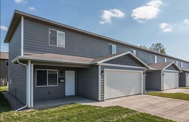
Property Record
4401 E 61St St, Sioux Falls, SD 57108

Property Detail
4401 E 61St St
Sioux Falls, SD-MN
SF - SYCAMORE SPRINGS ADD - LOT 4 - BLK 6
283.10.06.001
Lincoln
Commercialnec
South Dakota
MUNICIPALI
4
B and X Area of moderate flood hazard, usually the area between the limits of the 100-year and 500-year floods.
2.56 AC
2024
Sioux Falls
2024
Other Market Areas
010112
NEARBY LISTINGS FOR SALE OR LEASE
DEMOGRAPHICS near 4401 E 61St St
1 mile
3 mile
5 mile
2025 Total Population
11,458
54,109
137,855
2030 Population
12,688
58,383
148,265
Pop Growth 2025-2030
+ 10.73%
+ 7.90%
+ 7.55%
Average Age
39
39
38
2025 Total Households
4,800
22,043
55,867
HH Growth 2025-2030
+ 11.38%
+ 8.46%
+ 7.83%
Median Household Inc
$93,292
$83,651
$75,508
Avg Household Size
2.30
2.40
2.40
2025 Avg HH Vehicles
2.00
2.00
2.00
Median Home Value
$385,905
$356,709
$333,038
Median Year Built
2011
2002
1995
Nearby Places
Map Layers
Map Styles
 Street
 Aerial
Transit
 Traffic
 Biking
Places
Listings with unknown addresses are not visible on the map
- Restaurants
- Banks
- Shops
- Fitness
- Groceries
PUBLIC TRANSPORTATION
AIRPORT
Joe Foss Field
Drive
Walk
Distance
Joe Foss Field
32 min
10.5 mi
Nearby Properties
Address
Land Use
TOTAL SIZE
Lot Size
Zoning
Address
Land Use
TOTAL SIZE
Lot Size
Zoning
11.33 AC
MUNICIPALI
Address
Land Use
TOTAL SIZE
Lot Size
Zoning
15.39 AC
Address
Land Use
TOTAL SIZE
Lot Size
Zoning
4,358 SF
14.79 AC
Address
Land Use
TOTAL SIZE
Lot Size
Zoning
15.24 AC
MUNICIPALI
Address
Land Use
TOTAL SIZE
Lot Size
Zoning
3,306 SF
17.41 AC
Address
Land Use
TOTAL SIZE
Lot Size
Zoning
94,624 SF
12.31 AC
Address
Land Use
TOTAL SIZE
Lot Size
Zoning
11,800 SF
11.78 AC
Address
Land Use
TOTAL SIZE
Lot Size
Zoning
2,406 SF
13.76 AC
Address
Land Use
TOTAL SIZE
Lot Size
Zoning
8.02 AC
MUNICIPALI
Address
Land Use
TOTAL SIZE
Lot Size
Zoning
92,195 SF
8 AC
Address
Land Use
TOTAL SIZE
Lot Size
Zoning
9.42 AC
MUNICIPALI
Address
Land Use
TOTAL SIZE
Lot Size
Zoning
87,328 SF
6.92 AC
Address
Land Use
TOTAL SIZE
Lot Size
Zoning
7.59 AC
MUNICIPALI
Address
Land Use
TOTAL SIZE
Lot Size
Zoning
5.85 AC
Address
Land Use
TOTAL SIZE
Lot Size
Zoning
11.91 AC
MUNICIPALI
Address
Land Use
TOTAL SIZE
Lot Size
Zoning
10.24 AC
MUNICIPALI
Address
Land Use
TOTAL SIZE
Lot Size
Zoning
8.09 AC
MUNICIPALI
Address
Land Use
TOTAL SIZE
Lot Size
Zoning
9.15 AC
MUNICIPALI
Address
Land Use
TOTAL SIZE
Lot Size
Zoning
9.15 AC
MUNICIPALI
Address
Land Use
TOTAL SIZE
Lot Size
Zoning
7.63 AC
MUNICIPALI
Address
Land Use
TOTAL SIZE
Lot Size
Zoning
4.64 AC
MUNICIPALI
Address
Land Use
TOTAL SIZE
Lot Size
Zoning
5.99 AC
MUNICIPALI
Address
Land Use
TOTAL SIZE
Lot Size
Zoning
6 AC
MUNICIPALI
Address
Land Use
TOTAL SIZE
Lot Size
Zoning
4.40 AC
MUNICIPALI
Address
Land Use
TOTAL SIZE
Lot Size
Zoning
8.28 AC
MUNICIPALI
Address
Land Use
TOTAL SIZE
Lot Size
Zoning
10.39 AC
MUNICIPALI
Address
Land Use
TOTAL SIZE
Lot Size
Zoning
5.44 AC
MUNICIPALI
Address
Land Use
TOTAL SIZE
Lot Size
Zoning
3.77 AC
MUNICIPALI
Address
Land Use
TOTAL SIZE
Lot Size
Zoning
125,520 SF
5.61 AC
Address
Land Use
TOTAL SIZE
Lot Size
Zoning
58,932 SF
4.93 AC
The World's #1 Commercial Real Estate Marketplace
Connect with us
© 2026 CoStar Group
The information above has been obtained from sources believed reliable. While we do not doubt its accuracy we have not verified it and make no guarantee, warranty or representation about it. It is your responsibility to independently confirm its accuracy and completeness. Any projections, opinions, assumptions, or estimates used are for example only and do not represent the current or future performance of the property. The value of this transaction to you depends on tax and other factors which should be evaluated by your tax, financial, and legal advisors. You and your advisors should conduct a careful, independent investigation of the property to determine to your satisfaction the suitability of the property for your needs.