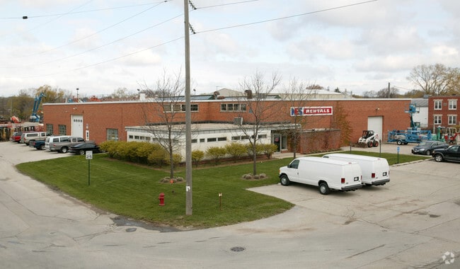
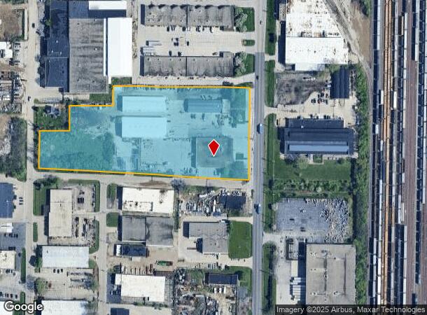
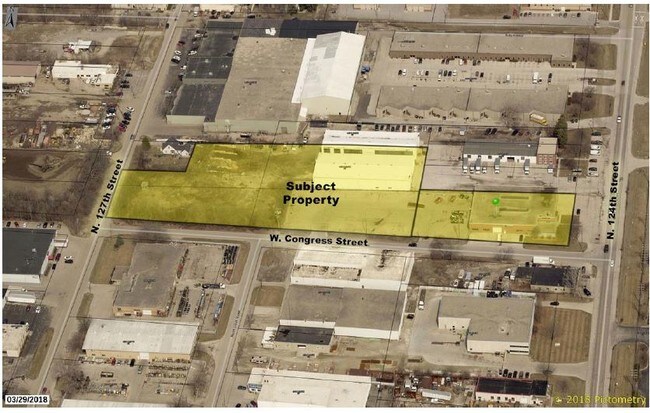
Property Record
4401 N 124Th St, Brookfield, WI 53005
NEARBY LISTINGS FOR SALE OR LEASE
Property Detail
4401 N 124Th St
Milwaukee-Waukesha-West Allis, WI
Home Fields Assessment
BRC-1012-018
LOTS 1 & 2 BLK 4 ACRE HOME FIELDS ASSESSMENT MAP NO 6 PT S1/2 SEC 1 T7N R20E
Commercialnec
Waukesha
X
Wisconsin
55133C0227H
1,2
2024
1.01 AC
2024
Brookfield/New Berlin
200700
Milwaukee/Madison
DEMOGRAPHICS near 4401 N 124Th St
1 Mile
3 Mile
5 Mile
2024 Total Population
4,201
75,014
226,346
2029 Population
4,326
74,854
225,175
Pop Growth 2024-2029
+ 2.98%
(0.21%)
(0.52%)
Average Age
42
39
39
2024 Total Households
1,841
30,481
90,597
HH Growth 2024-2029
+ 3.10%
(0.30%)
(0.60%)
Median Household Inc
$75,660
$71,768
$69,238
Avg Household Size
2.30
2.40
2.40
2024 Avg HH Vehicles
2.00
2.00
2.00
Median Home Value
$238,501
$238,608
$249,471
Median Year Built
1960
1961
1958
Nearby Places
Map Layers
Map Styles
 Street
 Aerial
- Restaurants
- Banks
- Shops
- Fitness
- Groceries
PUBLIC TRANSPORTATION
AIRPORT
General Mitchell International
DRIVE
WALK
Distance
General Mitchell International
25 min
19.0 mi
Freight Ports
Port of Baltimore
DRIVE
WALK
Distance
Port of Baltimore
1 min
651.9 mi
SALE & LEASE HISTORY
LISTING DATE
SALE/LEASE

May 16, 2018
For Lease
Nearby Properties
Address
Land Use
TOTAL SIZE
Lot Size
Zoning
Address
Land Use
TOTAL SIZE
Lot Size
Zoning
70.73 AC
Address
Land Use
TOTAL SIZE
Lot Size
Zoning
18.95 AC
Address
Land Use
TOTAL SIZE
Lot Size
Zoning
78,185 SF
73.67 AC
M1
Address
Land Use
TOTAL SIZE
Lot Size
Zoning
26.49 AC
Address
Land Use
TOTAL SIZE
Lot Size
Zoning
4.99 AC
Address
Land Use
TOTAL SIZE
Lot Size
Zoning
1.91 AC
Address
Land Use
TOTAL SIZE
Lot Size
Zoning
28,800 SF
3.30 AC
C2
Address
Land Use
TOTAL SIZE
Lot Size
Zoning
2.45 AC
C2
Address
Land Use
TOTAL SIZE
Lot Size
Zoning
387,379 SF
20.25 AC
Address
Land Use
TOTAL SIZE
Lot Size
Zoning
8.03 AC
RM1
Address
Land Use
TOTAL SIZE
Lot Size
Zoning
1.84 AC
Address
Land Use
TOTAL SIZE
Lot Size
Zoning
16.01 AC
Address
Land Use
TOTAL SIZE
Lot Size
Zoning
106,495 SF
9.70 AC
PUD
Address
Land Use
TOTAL SIZE
Lot Size
Zoning
Address
Land Use
TOTAL SIZE
Lot Size
Zoning
Address
Land Use
TOTAL SIZE
Lot Size
Zoning
102,604 SF
12.67 AC
PUD
Address
Land Use
TOTAL SIZE
Lot Size
Zoning
1.74 AC
Address
Land Use
TOTAL SIZE
Lot Size
Zoning
21.66 AC
M2
Address
Land Use
TOTAL SIZE
Lot Size
Zoning
11.66 AC
C2
Address
Land Use
TOTAL SIZE
Lot Size
Zoning
4.94 AC
Address
Land Use
TOTAL SIZE
Lot Size
Zoning
12.48 AC
IL1
Address
Land Use
TOTAL SIZE
Lot Size
Zoning
221,548 SF
11.80 AC
PD
Address
Land Use
TOTAL SIZE
Lot Size
Zoning
42.07 AC
IL1
Address
Land Use
TOTAL SIZE
Lot Size
Zoning
181,083 SF
8.50 AC
Address
Land Use
TOTAL SIZE
Lot Size
Zoning
14.96 AC
C2
Address
Land Use
TOTAL SIZE
Lot Size
Zoning
115,500 SF
13.08 AC
Address
Land Use
TOTAL SIZE
Lot Size
Zoning
515,706 SF
26.65 AC
Address
Land Use
TOTAL SIZE
Lot Size
Zoning
1.42 AC
Address
Land Use
TOTAL SIZE
Lot Size
Zoning
14.45 AC
Address
Land Use
TOTAL SIZE
Lot Size
Zoning
12.73 AC
C2
The World's #1 Commercial Real Estate Marketplace
Connect with us
© 2025 CoStar Group
The information above has been obtained from sources believed reliable. While we do not doubt its accuracy we have not verified it and make no guarantee, warranty or representation about it. It is your responsibility to independently confirm its accuracy and completeness. Any projections, opinions, assumptions, or estimates used are for example only and do not represent the current or future performance of the property. The value of this transaction to you depends on tax and other factors which should be evaluated by your tax, financial, and legal advisors. You and your advisors should conduct a careful, independent investigation of the property to determine to your satisfaction the suitability of the property for your needs.