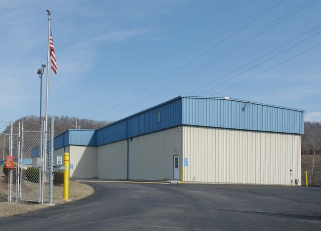
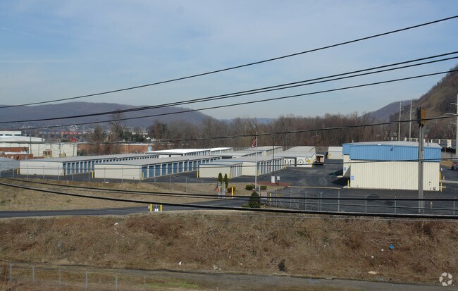
Property Record
4401 N 6Th St, Harrisburg, PA 17110


NEARBY LISTINGS FOR SALE OR LEASE
-
-
View all Harrisburg listings for lease on LoopNet.com
Property Detail
4401 N 6Th St
62-006-079
Gerald C Grove Surv
Industrialgeneral
Dauphin
AE
Pennsylvania
42043C0309D
10.21 AC
2025
Harrisburg Area East
2025
Philadelphia
021800
Harrisburg-Carlisle, PA
5,000 SF
DEMOGRAPHICS near 4401 N 6Th St
1 Mile
3 Mile
5 Mile
2024 Total Population
2,387
33,056
128,785
2029 Population
2,454
34,211
133,526
Pop Growth 2024-2029
+ 2.81%
+ 3.49%
+ 3.68%
Average Age
43
41
40
2024 Total Households
993
14,066
54,737
HH Growth 2024-2029
+ 2.82%
+ 3.53%
+ 3.82%
Median Household Inc
$102,083
$74,001
$64,308
Avg Household Size
2.40
2.30
2.30
2024 Avg HH Vehicles
2.00
2.00
2.00
Median Home Value
$192,512
$189,370
$185,319
Median Year Built
1963
1977
1966
Nearby Places
Map Layers
Map Styles
 Street
 Aerial
- Restaurants
- Banks
- Shops
- Fitness
- Groceries
PUBLIC TRANSPORTATION
AIRPORT
Harrisburg International
DRIVE
WALK
Distance
Harrisburg International
19 min
15.9 mi
Freight Ports
Port of Baltimore
DRIVE
WALK
Distance
Port of Baltimore
1 min
75.1 mi
SALE & LEASE HISTORY
LISTING DATE
SALE/LEASE

Sep 25, 2016
For Lease
Nearby Properties
Address
Land Use
TOTAL SIZE
Lot Size
Zoning
Address
Land Use
TOTAL SIZE
Lot Size
Zoning
615,797 SF
59.70 AC
Address
Land Use
TOTAL SIZE
Lot Size
Zoning
3,025 SF
274.13 AC
Address
Land Use
TOTAL SIZE
Lot Size
Zoning
577,075 SF
39.55 AC
Address
Land Use
TOTAL SIZE
Lot Size
Zoning
1,155,340 SF
3.94 AC
Address
Land Use
TOTAL SIZE
Lot Size
Zoning
638,721 SF
47.78 AC
Address
Land Use
TOTAL SIZE
Lot Size
Zoning
125,255 SF
26.65 AC
Address
Land Use
TOTAL SIZE
Lot Size
Zoning
192,390 SF
43.19 AC
Address
Land Use
TOTAL SIZE
Lot Size
Zoning
242,534 SF
47.26 AC
Address
Land Use
TOTAL SIZE
Lot Size
Zoning
228,141 SF
42.50 AC
Address
Land Use
TOTAL SIZE
Lot Size
Zoning
1,989 SF
16.62 AC
Address
Land Use
TOTAL SIZE
Lot Size
Zoning
665,098 SF
14 AC
Address
Land Use
TOTAL SIZE
Lot Size
Zoning
Address
Land Use
TOTAL SIZE
Lot Size
Zoning
9.88 AC
Address
Land Use
TOTAL SIZE
Lot Size
Zoning
51,300 SF
11.36 AC
Address
Land Use
TOTAL SIZE
Lot Size
Zoning
24.77 AC
Address
Land Use
TOTAL SIZE
Lot Size
Zoning
16.61 AC
Address
Land Use
TOTAL SIZE
Lot Size
Zoning
114,044 SF
23.13 AC
Address
Land Use
TOTAL SIZE
Lot Size
Zoning
15.58 AC
Address
Land Use
TOTAL SIZE
Lot Size
Zoning
39,066 SF
6.42 AC
Address
Land Use
TOTAL SIZE
Lot Size
Zoning
3,192 SF
17.32 AC
Address
Land Use
TOTAL SIZE
Lot Size
Zoning
19,558 SF
12.50 AC
Address
Land Use
TOTAL SIZE
Lot Size
Zoning
8,230 SF
7.82 AC
Address
Land Use
TOTAL SIZE
Lot Size
Zoning
0.15 AC
Address
Land Use
TOTAL SIZE
Lot Size
Zoning
42,030 SF
10.29 AC
Address
Land Use
TOTAL SIZE
Lot Size
Zoning
73,101 SF
13.39 AC
Address
Land Use
TOTAL SIZE
Lot Size
Zoning
3,100 SF
24.70 AC
Address
Land Use
TOTAL SIZE
Lot Size
Zoning
110,200 SF
3.91 AC
Address
Land Use
TOTAL SIZE
Lot Size
Zoning
13.71 AC
Address
Land Use
TOTAL SIZE
Lot Size
Zoning
9.39 AC
Address
Land Use
TOTAL SIZE
Lot Size
Zoning
16,872 SF
7.29 AC
The World's #1 Commercial Real Estate Marketplace
Connect with us
© 2025 CoStar Group
The information above has been obtained from sources believed reliable. While we do not doubt its accuracy we have not verified it and make no guarantee, warranty or representation about it. It is your responsibility to independently confirm its accuracy and completeness. Any projections, opinions, assumptions, or estimates used are for example only and do not represent the current or future performance of the property. The value of this transaction to you depends on tax and other factors which should be evaluated by your tax, financial, and legal advisors. You and your advisors should conduct a careful, independent investigation of the property to determine to your satisfaction the suitability of the property for your needs.