Property Record
4401 N State Road 29, Michigantown, IN 46057
NEARBY LISTINGS FOR SALE OR LEASE
-
-
View all Michigantown listings for sale on LoopNet.com
Property Detail
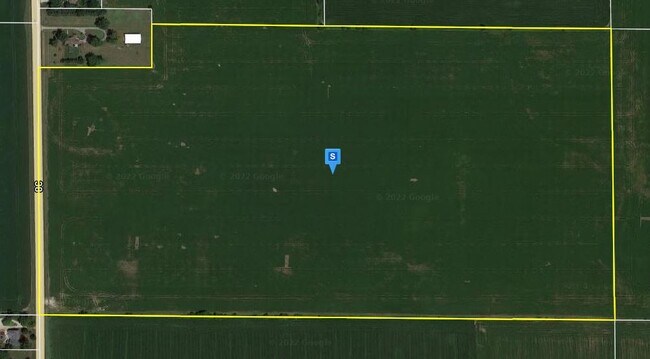
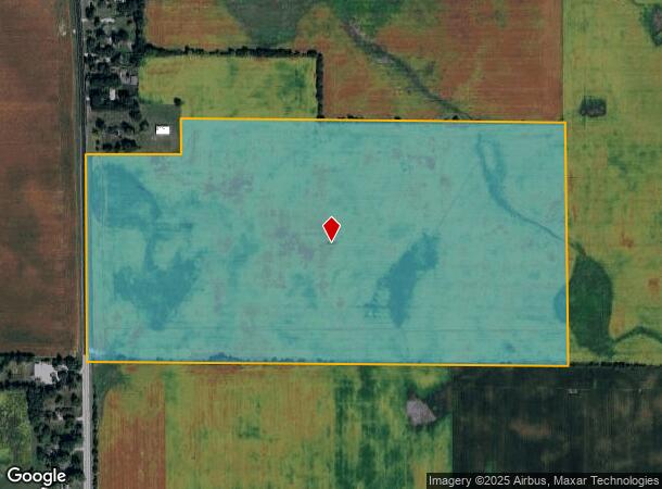
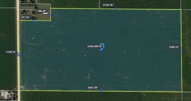
4401 N State Road 29
12-10-26-151-001.000-004
003-02038-00 PT S NW 26-21-1W 75.65A 545-547-A
Agriculturalland
Clinton
X
Indiana
18011C0050E
75.65 AC
2024
Lafayette/Kokomo
2024
Other Market Areas
950200
Frankfort, IN
DEMOGRAPHICS near 4401 N State Road 29
1 Mile
3 Mile
5 Mile
2024 Total Population
243
8,084
19,756
2029 Population
242
8,038
19,719
Pop Growth 2024-2029
(0.41%)
(0.57%)
(0.19%)
Average Age
43
38
38
2024 Total Households
90
3,034
7,259
HH Growth 2024-2029
0.00%
(0.66%)
(0.18%)
Median Household Inc
$59,166
$53,656
$50,139
Avg Household Size
2.70
2.60
2.60
2024 Avg HH Vehicles
2.00
2.00
2.00
Median Home Value
$154,629
$135,972
$119,097
Median Year Built
1969
1956
1955
Nearby Places
Map Layers
Map Styles
 Street
 Aerial
- Restaurants
- Banks
- Shops
- Fitness
- Groceries
Nearby Properties
Address
Land Use
TOTAL SIZE
Lot Size
Zoning
Address
Land Use
TOTAL SIZE
Lot Size
Zoning
50,034 SF
6.80 AC
Address
Land Use
TOTAL SIZE
Lot Size
Zoning
33,296 SF
10 AC
Address
Land Use
TOTAL SIZE
Lot Size
Zoning
93,138 SF
3.69 AC
Address
Land Use
TOTAL SIZE
Lot Size
Zoning
73,861 SF
10.57 AC
Address
Land Use
TOTAL SIZE
Lot Size
Zoning
36,349 SF
4.34 AC
Address
Land Use
TOTAL SIZE
Lot Size
Zoning
11,086 SF
2.62 AC
Address
Land Use
TOTAL SIZE
Lot Size
Zoning
9,870 SF
8.26 AC
Address
Land Use
TOTAL SIZE
Lot Size
Zoning
16,984 SF
5.69 AC
Address
Land Use
TOTAL SIZE
Lot Size
Zoning
53,404 SF
9.49 AC
Address
Land Use
TOTAL SIZE
Lot Size
Zoning
17,940 SF
8.27 AC
Address
Land Use
TOTAL SIZE
Lot Size
Zoning
6,691 SF
2.59 AC
Address
Land Use
TOTAL SIZE
Lot Size
Zoning
19,970 SF
2.84 AC
Address
Land Use
TOTAL SIZE
Lot Size
Zoning
2,048 SF
4.15 AC
Address
Land Use
TOTAL SIZE
Lot Size
Zoning
25,842 SF
0.57 AC
Address
Land Use
TOTAL SIZE
Lot Size
Zoning
12,000 SF
1.85 AC
Address
Land Use
TOTAL SIZE
Lot Size
Zoning
16,052 SF
1.60 AC
Address
Land Use
TOTAL SIZE
Lot Size
Zoning
69,134 SF
11.33 AC
Address
Land Use
TOTAL SIZE
Lot Size
Zoning
21,544 SF
11.94 AC
Address
Land Use
TOTAL SIZE
Lot Size
Zoning
32,815 SF
5.67 AC
Address
Land Use
TOTAL SIZE
Lot Size
Zoning
3,200 SF
8.50 AC
Address
Land Use
TOTAL SIZE
Lot Size
Zoning
14,973 SF
3.57 AC
Address
Land Use
TOTAL SIZE
Lot Size
Zoning
9,580 SF
0.35 AC
Address
Land Use
TOTAL SIZE
Lot Size
Zoning
31,248 SF
2.68 AC
Address
Land Use
TOTAL SIZE
Lot Size
Zoning
13,682 SF
0.29 AC
Address
Land Use
TOTAL SIZE
Lot Size
Zoning
7,533 SF
0.77 AC
Address
Land Use
TOTAL SIZE
Lot Size
Zoning
13.50 AC
Address
Land Use
TOTAL SIZE
Lot Size
Zoning
3,600 SF
1.95 AC
Address
Land Use
TOTAL SIZE
Lot Size
Zoning
6,976 SF
0.76 AC
Address
Land Use
TOTAL SIZE
Lot Size
Zoning
2,820 SF
18.69 AC
Address
Land Use
TOTAL SIZE
Lot Size
Zoning
6,621 SF
0.85 AC
The World's #1 Commercial Real Estate Marketplace
Connect with us
© 2025 CoStar Group
The information above has been obtained from sources believed reliable. While we do not doubt its accuracy we have not verified it and make no guarantee, warranty or representation about it. It is your responsibility to independently confirm its accuracy and completeness. Any projections, opinions, assumptions, or estimates used are for example only and do not represent the current or future performance of the property. The value of this transaction to you depends on tax and other factors which should be evaluated by your tax, financial, and legal advisors. You and your advisors should conduct a careful, independent investigation of the property to determine to your satisfaction the suitability of the property for your needs.